Tomas Pueyo Profile picture
Jun 25 7 tweets 3 min read Read on X
Why did 🇮🇱Israel strike 🇮🇷Iran now, and not months or years ago or in the future?

A unique combination of a dozen factors converged to make the moment unique for 🇮🇱Israel: 🧵
1. No Hamas to its southwest
2. No Hezbollah to its north
3. No Assad threat to the northeast
4... Image
4. No more Syrian army to attack 🇮🇱Israel's planes: As the new forces of HTS took over Syria, Israel bombed all the existing Syrian military. No more fighter jets or surface-to-air missiles to threaten 🇮🇱Israel Image
5. Ability to fly over Syria to refuel
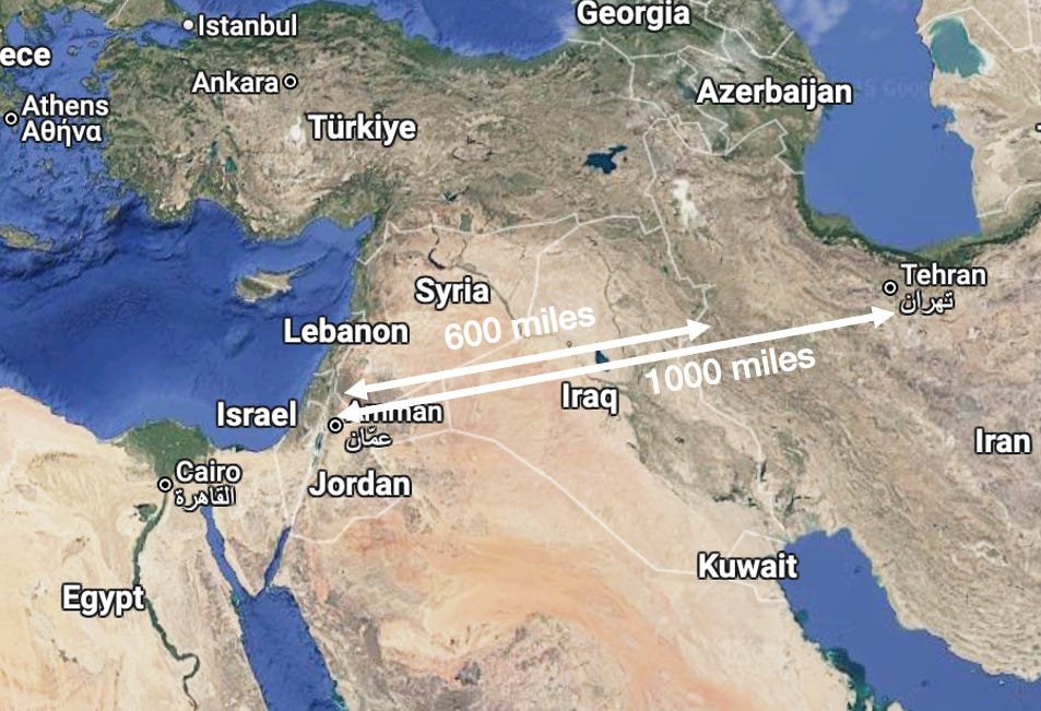
This is critical, because 🇮🇷Iran is ~600-1000 miles away from 🇮🇱Israel, so 1200-2000 miles round trip

The range of Israel’s stealth F35 is only about 1,350 mi
To operate inside 🇮🇷Iran, 🇮🇱Israel needed refueling over Syria Image
Image
6. Full visibility atop Mt Hermon
After the fall of the Assad Regime, Israel took over some border ground with Syria, which includes Mt Hermon, the tallest peak in the region. With that, there are no more blind spots in Israel's visibility in the region Image
Image
7. Russia is too weak to help, bogged down by war in Ukraine
8. Netanyahu has a window of opportunity: There are parliamentary elections in a bit over a year
9. Trump is in power too: Dems have been in the White House for 12 of the last 17 years, and are less aggressive re Iran
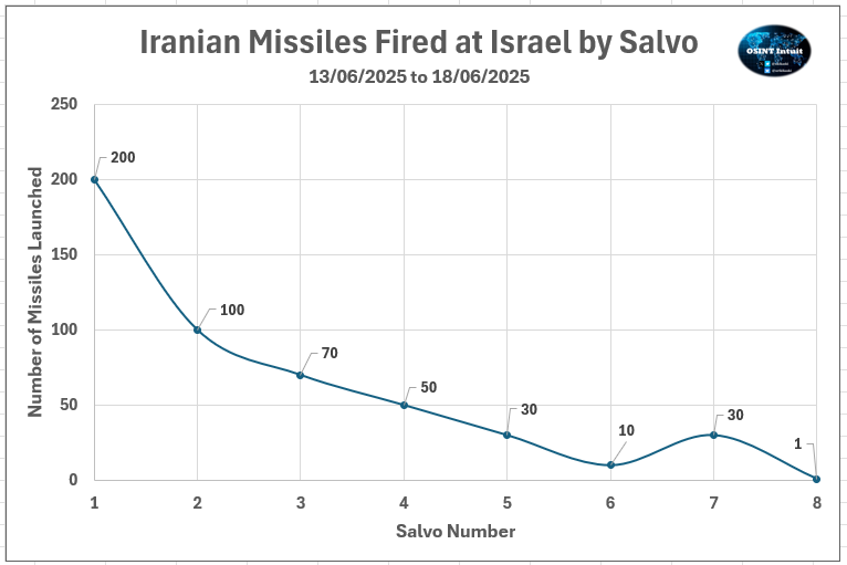
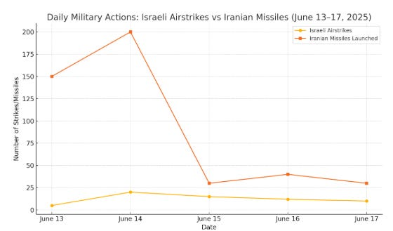
10. In April & October 2024, 🇮🇷Iran sent missiles & drones to 🇮🇱Israel, but failed to make serious damage. 🇮🇱Israel reacted by bombing several military facilities in 🇮🇷Iran, seriously degrading its air defense. That gave a window for 🇮🇱Israel to continue attacking now Image
11. 🇮🇷Iran has witnessed how all its weapons against 🇮🇱Israel have been defeated:
• All proxies neutralized
• All weapons, including drones & ballistic missiles, failed to make serious damage to 🇮🇱Israel

So 🇮🇷Iran moved closer to getting the bomb

• • •

Missing some Tweet in this thread? You can try to force a refresh
 

Keep Current with Tomas Pueyo

Tomas Pueyo Profile picture

Stay in touch and get notified when new unrolls are available from this author!

Read all threads

This Thread may be Removed Anytime!

PDF

Twitter may remove this content at anytime! Save it as PDF for later use!

Try unrolling a thread yourself!

how to unroll video
  1. Follow @ThreadReaderApp to mention us!

  2. From a Twitter thread mention us with a keyword "unroll"
@threadreaderapp unroll

Practice here first or read more on our help page!

More from @tomaspueyo

Jun 23
Was 🇮🇷trying to get a nuclear bomb?

1. From Feb 2025 to Jun 2025, it increased its amount of enriched uranium by 50%
2. It now had 400kg of highly enriched uranium, enough for 9-10 bombs
3. This is 60% enriched uranium. Fuel only requires 5% enrichment.
4... 🧵
4. It's easy to go from 60% to 90% (weapons grade), it only takes weeks
5. The only country on Earth with such enriched uranium and without a bomb is 🇮🇷Iran
6. The IAEA (nuclear watchdog) found 3 secret nuclear sites
7. When 🇮🇷Iran didn't respond to this accusation, the IAEA censured it
8. 🇮🇷Iran responded to the censoring by saying it would open a 3rd enrichment site in a secret spot
Read 9 tweets
Jun 22
Now that the 🇺🇸US has bombed 3 of 🇮🇷Iran's nuclear sites, where will the war go from here?
It depends on 🇮🇱Israel: 🧵
🇮🇷Iran never wanted the war, and its forces are being decimated. Its ability to send missiles to 🇮🇱Israel is being degraded every day. If it could sign a ceasefire while saving face, it would Image
Meanwhile, 🇮🇱Israel has kept striking Iran non stop. Its daily airstrikes didn't go down substantially in the first few days. Its ability to keep striking 🇮🇷Iran remains unabated

So when will it stop? Image
Read 13 tweets
Jun 19
Can there be an invasion of Iran? Hardly. Two maps explain why, and also why Iran is the way it is today, whether its regime will fall, what other superpowers will do, and in general why Iran is the way it is today

1. Iran is a mountain & desert fortress Image
Here's a topograhic map
West: Zagros
North: Caspian Sea + Caucasus, Albroz, & Kopet-Dag mountains + Karakum Desert
East: Mountains + Dasht-e Kavir / Lut Deserts
South: Sea

The only truly exposed area is the southwestern corner of Khuzestan, which is a swamp Image
The biggest superpowers lie to the west, and there the very broad Zagros make it really hard to conquer Iran. The mountain range is tall and wide, making logistics similar to Afghanistan. Very hard.

Iraq learned it the hard way when it tried to attack there in 1980 Image
Read 20 tweets
Jun 19
Was 🇮🇷Iran trying to develop nuclear weapons?

Listening to the debate, it looks like 🇮🇱Israel & the 🇺🇸US intelligence community disagreed, but that's not really the case!

Both thought Iran was weeks to months away from being able to develop the bomb

So what's the disagreement?
Here are more facts:
• Tehran had just announced a 3rd enrichment site in an undisclosed place
• The International Atomic Energy Agency (IAEA) had recently produced a report censoring Iran for the 1st time in 20y
• It accused Iran of 3 undisclosed nuclear sites
• It claimed Iran had enough enriched uranium for 9-10 nuclear bombs
• All the other countries in the world who have enriched uranium at the same level also have nuclear weapons. Iran is the only country that doesn't have these weapons yet enriches uranium as much
Read 7 tweets
Jun 3
Nuclear is the best source of energy across nearly all the factors that matter. It's the safest, cleanest, densest, most sustainable, geopolitically stable, predictable, dispatchable, and can be cheap.

1. SAFEST
It kills 1000x less than coal Image
Living close to a nuclear power plant for one year gives you less radiation than eating a banana (graph is logarithmic) Image
Image
2. CLEANEST
Accounting for all the lifecycle of all energies, it's the one that emits the least CO2 Image
Read 22 tweets
Apr 28
Over 80% of Canada's population lives in these 3 areas.
Why these 3?
Why so disconnected?
What are the consequences of that?
Here's why: 🧵 Image
ST LAWRENCE VALLEY & GREAT LAKES
About 55% of Canadians live here, on the riverbanks of the St Lawrence River and the Great Lakes. Why?

And as soon as you go a bit farther north of the St Lawrence, population disappears. Why? Image
1. History: This is where Europeans came from, and the place they settled first

Also, the St Lawrence river is naturally navigable until Montréal by seafaring ships—and up till the Great Lakes since the 1800s

That meant direct trade with Europe & the world➡️wealth Image
Read 18 tweets

Did Thread Reader help you today?

Support us! We are indie developers!


This site is made by just two indie developers on a laptop doing marketing, support and development! Read more about the story.

Become a Premium Member ($3/month or $30/year) and get exclusive features!

Become Premium

Don't want to be a Premium member but still want to support us?

Make a small donation by buying us coffee ($5) or help with server cost ($10)

Donate via Paypal

Or Donate anonymously using crypto!

Ethereum

0xfe58350B80634f60Fa6Dc149a72b4DFbc17D341E copy

Bitcoin

3ATGMxNzCUFzxpMCHL5sWSt4DVtS8UqXpi copy

Thank you for your support!

Follow Us!

:(