Between Pokrovsk and Kostiantynivka, I mapped 3 200 russian 🇷🇺 airstrikes in 3 months, including 1 400 new ones from july 11th to august 11th.
Russian airforce is launching massive strikes at ukrainian 🇺🇦position, supporting a large offensive.
🧵THREAD🧵1/23 ⬇️
Russian airforce is launching massive strikes at ukrainian 🇺🇦position, supporting a large offensive.
🧵THREAD🧵1/23 ⬇️

In this single satellite picture taken north of Pokrovsk, we can see no less than 50 airstrikes, with more than half hitting treelines and buildings where ukrainian 🇺🇦soldiers are hidding.
All those happened since june 11th.
All those happened since june 11th.

I started mapping those airstrikes near Pokrovsk in late june when I noticed large strikes against ukrainian fortifications.
Since then, I put dots for every airstrike, with different color each month. Here is may to june 11th 2025, 1 100 airstrikes.
Since then, I put dots for every airstrike, with different color each month. Here is may to june 11th 2025, 1 100 airstrikes.

One month later, I mapped 700 new airstrikes, in orange, from june 11th to july 11th. In black, the evolving frontline at the time.
You can see a clear shift to the west, with more and more dots just north of Pokrovsk.
You can see a clear shift to the west, with more and more dots just north of Pokrovsk.

How do I know if it is really an airstrike ?
The particularity of FAB 500/1000/1500/3000 is that they are making big holes.
It is barely possible to see artillery holes, but we can see airstrikes holes, here, south of Myrnohrad.
The particularity of FAB 500/1000/1500/3000 is that they are making big holes.
It is barely possible to see artillery holes, but we can see airstrikes holes, here, south of Myrnohrad.

I'm using free access satellite imageries, here with Sentinel-2. With the way back and compare tools, I can easily notice airstrikes and holes, even in urban environment, when buildings are collapsing.
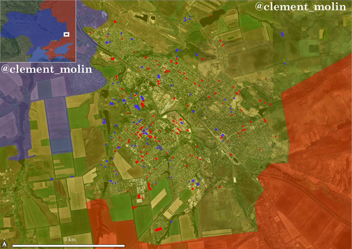
Here is an exclusive, my new map covering July 11th to August 11th.
I mapped a number of 1 400 🇷🇺 airstrikes this period, with the majority just north of Pokrovsk and near Shakove, we will talk about it just below.
I mapped a number of 1 400 🇷🇺 airstrikes this period, with the majority just north of Pokrovsk and near Shakove, we will talk about it just below.

Thus, I have in total ~3 200 airstrikes impacts from Kostiantynivka (I stop the count on the railway west of Toretsk) and Myrnohrod (here too, I do not include the area south of Pokrovsk).
This is a ~50km long front, the most active and dangerous for Ukraine.
This is a ~50km long front, the most active and dangerous for Ukraine.

The situation is particularly impressive in some areas of the current frontline. The town of Rodynske, key of northern Pokrovsk has been hit by ~150 KABs, mainly in the last month.

You can see on this satellite image how destroyed the town of Rodynske is. Every overpass show more holes and destroyed buildings.
On the Dobropilla frontline, I managed to map around 50 airstrikes in the town of Bilytske, this is where russian forces are making progress and also where they made a breakthrough north.

More interestingly, I managed to find around 20 new airstrikes aroun the new Donbass line.
This is where russian assault units managed to breakthrough as per deepstate reports.
This is where russian assault units managed to breakthrough as per deepstate reports.

You can see here more than 20 FAB impacts all around the hole in the defensive line. This probably stopped the urgent engineering work to fill the hole.
Russian forces may have entered the village here.
Russian forces may have entered the village here.

In the Shakove-Poltavka direction, I mapped around 1 000 strikes in the last 3 months. You can see how much effort they are putting here.
If Shakove falls, it will open the way north to expand the bridgehead.
If Shakove falls, it will open the way north to expand the bridgehead.

Finally in the Kostiantynivka direction there is also a lot of new airstrikes. You can see especially around the lake, where the ukrainians are ressuplying their forces west of Torestk.

Using those airstrikes impacts allow us to understand where Russia is willing to make a big push.
In this case, We can see they are going to push North of Pokrovsk to cut the city, near Dobropilla and Shakove.
In this case, We can see they are going to push North of Pokrovsk to cut the city, near Dobropilla and Shakove.

With the UMPK kit, russian bombers can use old bombs (FAB 500-1000-1500-3000) from 40 to 80km distance.
They are then unhammered by ukrainian fighters and air defense. Their effect is massive, forcing the ukrainians to retreat constantly.
They are then unhammered by ukrainian fighters and air defense. Their effect is massive, forcing the ukrainians to retreat constantly.

I did not only map the Pokrovsk frontline.
From Pokrovsk to Hulialpole, where russian forces are also making progress, I found around 1 000 impacts.
From Pokrovsk to Hulialpole, where russian forces are also making progress, I found around 1 000 impacts.

In Sumy, I also found massive airstrikes impacts.
People are saying Ukraine is slowly pushing back the russians, but at what price ? 2 500 airstrikes in this area for the last few months !
Villages, treelines and forest have been erased.
People are saying Ukraine is slowly pushing back the russians, but at what price ? 2 500 airstrikes in this area for the last few months !
Villages, treelines and forest have been erased.

For months, I've been mapping those strikes. It has proven largely useful.
The first map here was made a month ago. Where russian airforce is bombing, russian infantry is following.
The first map here was made a month ago. Where russian airforce is bombing, russian infantry is following.


Of course, I will continue to map other areas of the frontline.
Here for example, Siversk !
Here for example, Siversk !

Thank you for reading this. This work is unpaid and free, it takes me a lot of time. Medias, Military, Analysts and others are using it.
You can support me here : buymeacoffee.com/clement.molin
You can support me here : buymeacoffee.com/clement.molin
For the second day in a row, my thread bugged and I had to rewrite half of it, sorry for the inconveniance.
I see people seems to be very interested because everytime I post, I see new likes on the one just before !
I see people seems to be very interested because everytime I post, I see new likes on the one just before !
The most important for me is all the likes, comments and reposts of my work, it gives more strength !
Thank you all, especially for the thousands new ones.
Tomorrow, I will post an analysis of the Lyman and Kupiansk frontline (also called Oskil) in french 🇫🇷.
Thank you all, especially for the thousands new ones.
Tomorrow, I will post an analysis of the Lyman and Kupiansk frontline (also called Oskil) in french 🇫🇷.
• • •
Missing some Tweet in this thread? You can try to
force a refresh