In #Dobropilla, no one knows what's happening
It's been one month #Russia 🇷🇺 broke through the frontline in Dobropilla, central part of Donetsk oblast. After few days, this breakthrough was stopped and pushed back 🇺🇦.
Since then, no information has filtered :
🧵THREAD🧵1/17 ⬇️
It's been one month #Russia 🇷🇺 broke through the frontline in Dobropilla, central part of Donetsk oblast. After few days, this breakthrough was stopped and pushed back 🇺🇦.
Since then, no information has filtered :
🧵THREAD🧵1/17 ⬇️

Since weeks, you can see multiple maps of encirclements, of double encirclement and imaginary offensives. However, no one really knows what is happening there, perhaps even both sides command.
Both armies are positionned behind its ennemy, this is why it is impossible to map it.
Both armies are positionned behind its ennemy, this is why it is impossible to map it.


After the Dobropilla breakthrough, I posted worrying threads. Indeed, Russia pushed during weeks hundreds of soldiers behind the lines.
However, the lack of exploitation and successful counter-offensive managed to push back part of russian advance in the area.
However, the lack of exploitation and successful counter-offensive managed to push back part of russian advance in the area.

Most of the videos posted online are showing lone soldiers of one side or the other behing shelled in different places. It does not mean the area is controled by one side.
You have to understand new tactics : pushing between lines with no real control line.
You have to understand new tactics : pushing between lines with no real control line.
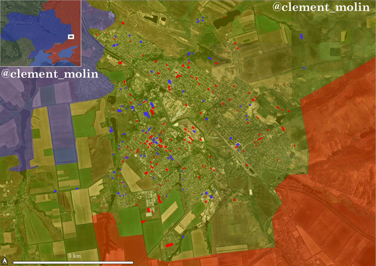
My main mean to understand the situation is the use of satellite imageries. With them, I can proove that Ukraine pushed on the western flank of russian presence in different directions (+/- 3).
I mapped in yellow all russian airstrikes since august 11th.
I mapped in yellow all russian airstrikes since august 11th.

Few interesting stuffs :
Ukraine continued to reinforce the hole in its defensive line recently (new barbed wire and dragon teeths.
Ukraine continued to reinforce the hole in its defensive line recently (new barbed wire and dragon teeths.

With airstrikes during the month, we can see Ukraine brought large reinforcements to the Donbass Line (multiple airstrikes) and even pushed south of it.
On the west, they also tryied to push. Only the green area has not been bombed in one month : probably grey zone or russian.
On the west, they also tryied to push. Only the green area has not been bombed in one month : probably grey zone or russian.

Here, you can see how Ukraine pushed slowly on the treelines around Nove Shakove. You can see multiples airstrikes impacts slowly going east.
More information about this push :
More information about this push :
https://x.com/Thorkill65/status/1967934698325262705
Now I will show you a map that I'm not sure at all (maybe 30%). It shows something people like to see : lines.
I put places where we are ~100% sure Ukraine is (multiple airstrikes) and where Russia is also ~100% sure (no airstrikes, no burn marks).
I put places where we are ~100% sure Ukraine is (multiple airstrikes) and where Russia is also ~100% sure (no airstrikes, no burn marks).

Basically, positions could be like this. Yellow are ukrainian positions and orange russians.
One behind on the other, relying on drones to survivre, hiding in bushes, houses, trenches far behind their lines...
No one can map this accurately.
One behind on the other, relying on drones to survivre, hiding in bushes, houses, trenches far behind their lines...
No one can map this accurately.

However, we can say something : analyse the broader situation.
Yes, Russia broke through the frontline in late august. They advanced 15km, establish small positions without supplies.
They even crossed the Donbass line, we have proofs of this, if it's not enough for people.
Yes, Russia broke through the frontline in late august. They advanced 15km, establish small positions without supplies.
They even crossed the Donbass line, we have proofs of this, if it's not enough for people.
However, the infiltration was too large and Ukraine slowly took back terrain, at least to the defensive line and on the west.
Russia failed to consolidate anything. This is largely due to the large obstacles that are changing the frontline, and no one is talking about it.
Russia failed to consolidate anything. This is largely due to the large obstacles that are changing the frontline, and no one is talking about it.

The presence of large anti-tank ditches (filled with barbed wire) reinforced by large barbed wire lines and dragon teeths with barbed wire makes every movement very difficult.
In this case, it takes days of walk to reach the small holes in the defense, for both sides.
In this case, it takes days of walk to reach the small holes in the defense, for both sides.

Thus, the situation hasn't mooved for a month there. Russia didn't made it to Pokrovsk or Dobropilla, pushing back for few months the final offensive on Donbass it was dreaming about.
Both sides continue to bring reinforcements. (an account to follow !)
Both sides continue to bring reinforcements. (an account to follow !)
https://x.com/WarUnitObserver/status/1967644945113813151

The drone warfare and the local terrain is making the area very difficult to understand. So : both sides are present in the same area, even them are probably not sure where they are.
Encirclements are probably happening, but their effects are none with drone supplies.
Encirclements are probably happening, but their effects are none with drone supplies.
This situation is largely favorable for Ukraine that is temporarly pushing back russian forces in the area. It gives them precious time to prepare new defensive lines, that will be more and more difficult and long to cross.
A word on Pokrovsk'E. The situation there (south-west Donetsk, Zaporizhia and Dnipropetrovsk frontline) is getting very bad.
There is no (0) defensive line around Pokrovsk'e. They finally started to dig on the H15 highway, but farther west... I will talk about it later.
There is no (0) defensive line around Pokrovsk'e. They finally started to dig on the H15 highway, but farther west... I will talk about it later.

• • •
Missing some Tweet in this thread? You can try to
force a refresh