Will Russia 🇷🇺 break the frontline again ?
Since few weeks, russian forces started again to push for Drujkivka, while hundreds of russians are still isolated.
I mapped all airstrikes there and at the same time, Ukraine 🇺🇦 is preparing the 3rd Donbass line🧑🔧.
🧵THREAD🧵1/25 ⬇️
Since few weeks, russian forces started again to push for Drujkivka, while hundreds of russians are still isolated.
I mapped all airstrikes there and at the same time, Ukraine 🇺🇦 is preparing the 3rd Donbass line🧑🔧.
🧵THREAD🧵1/25 ⬇️

Since two months, there have been a massive split between analysts. Pro-ukrainian or pro-russian sources are divided to understand how much km2 fell this month to Russia.
Many fail to understand the new logics of war.
Many fail to understand the new logics of war.


For example :
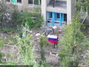
-Some will map an area as russian because a ukrainian drone striked russian soldiers there or a russian was seen with a flag.
-Some will map a large grey zone
I would myself map the grey zone for one main reason :
-Some will map an area as russian because a ukrainian drone striked russian soldiers there or a russian was seen with a flag.
-Some will map a large grey zone
I would myself map the grey zone for one main reason :
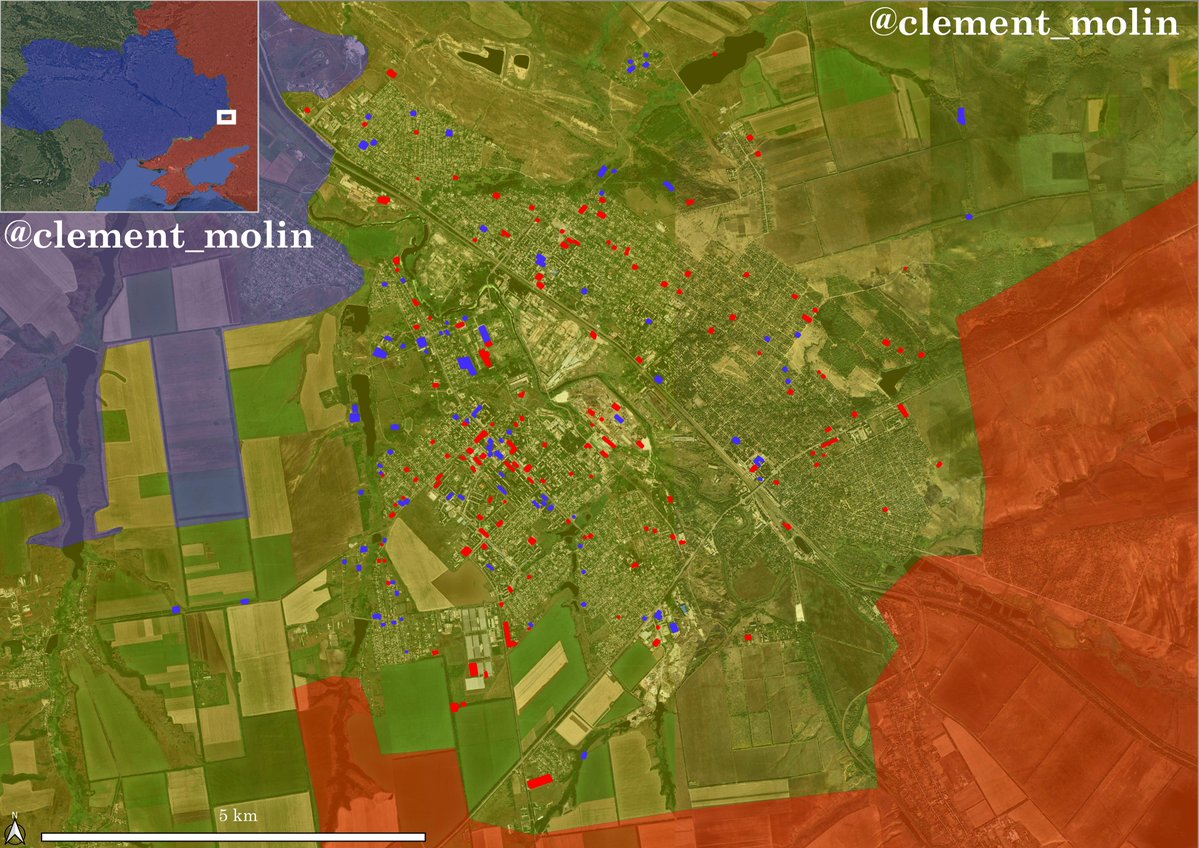
Here is a very useful graphic : you can easily have a red and a blue "porous line", where stronger positions of both sides are and multiple houses occupied by different armies in the same village.

The main area of misunderstanding is near the former Dobropilla breakthrough that was stopped and pushed back behind the defensive line.
This is how I see the situation : russians are isolated in pockets but not cut off directly, ukrainians sometimes push between those pockets.
This is how I see the situation : russians are isolated in pockets but not cut off directly, ukrainians sometimes push between those pockets.

Why ? Because first, they need to cross a ditch, barbed wire and dragon teeths that have not been breached. Then, they need to walk into the open.
So for now, they hold in their positions, wait for drone drop munitions and food and a future offensive to liberate their isolation.
So for now, they hold in their positions, wait for drone drop munitions and food and a future offensive to liberate their isolation.

Here is a very interesting article to understand how the war is now working, mainly for the hottest frontlines. Frontline is not a name anymore, they call this "killzone", because from 5 to 7km to the 0 line, drones are killing everyone.
texty.org.ua/projects/11592…
texty.org.ua/projects/11592…
As you already know, I'v been mapping airstrikes in the Pokrovsk-Kostiantynivka direction since may, every 11th of each month.
With those airstrikes, we can understand where Russia is not (they wouldn't throw airstrikes at their positions) and where Ukraine is.
With those airstrikes, we can understand where Russia is not (they wouldn't throw airstrikes at their positions) and where Ukraine is.

This month has seen a large decrease in the airstrikes campaign in the region. From 1917 last month, we are now having only 938 impacts, far less that the last 2 months.
There is however still a week before the end of my monthly count.
There is however still a week before the end of my monthly count.

Russian airstrikes in may coincide with their offensive to reach the north of Pokrovsk and encircle the city. At that time, I mapped around 1 056 airstrikes there.
A month later, in july 11th, I published a second map with around 650 airstrikes. We could see Russia was striking very hard the ukrainians around Shakove (between Pokrovsk and Drujkivka) and they were continuing their assault west of the previous one.

A month later in august 11th, It started getting crazier. Just days after the start of Dobropilla breakthrough, I mapped 1 411 airstrikes, in two main areas, supporting the large infiltration operation near Rodynske and Doborpilla.

With the three months added togethern we can see how the airstrikes are slowly moving west and north. We can also see an incredible concentration near Shakove, keep it in mind !

In august until september 11th, we saw how they changed their tactics to sustain their breakthrough in the line near Dibropilla. 1 917 FABs were dropped in a month, mainly around the breach, between Bilytske and Kucheriv Yar.
Also, we shouldn't forget about Kostiantynivka.
Also, we shouldn't forget about Kostiantynivka.

Finally, this month has seen a decrease in airstrikes due to the failure of the breakthrough and ukrainian counter-attacks.
North of Pokrovsk, all the strikes are aimed at disturbing logistics. But thhe main area of interest is now around Shakove and Drujkivka.
North of Pokrovsk, all the strikes are aimed at disturbing logistics. But thhe main area of interest is now around Shakove and Drujkivka.
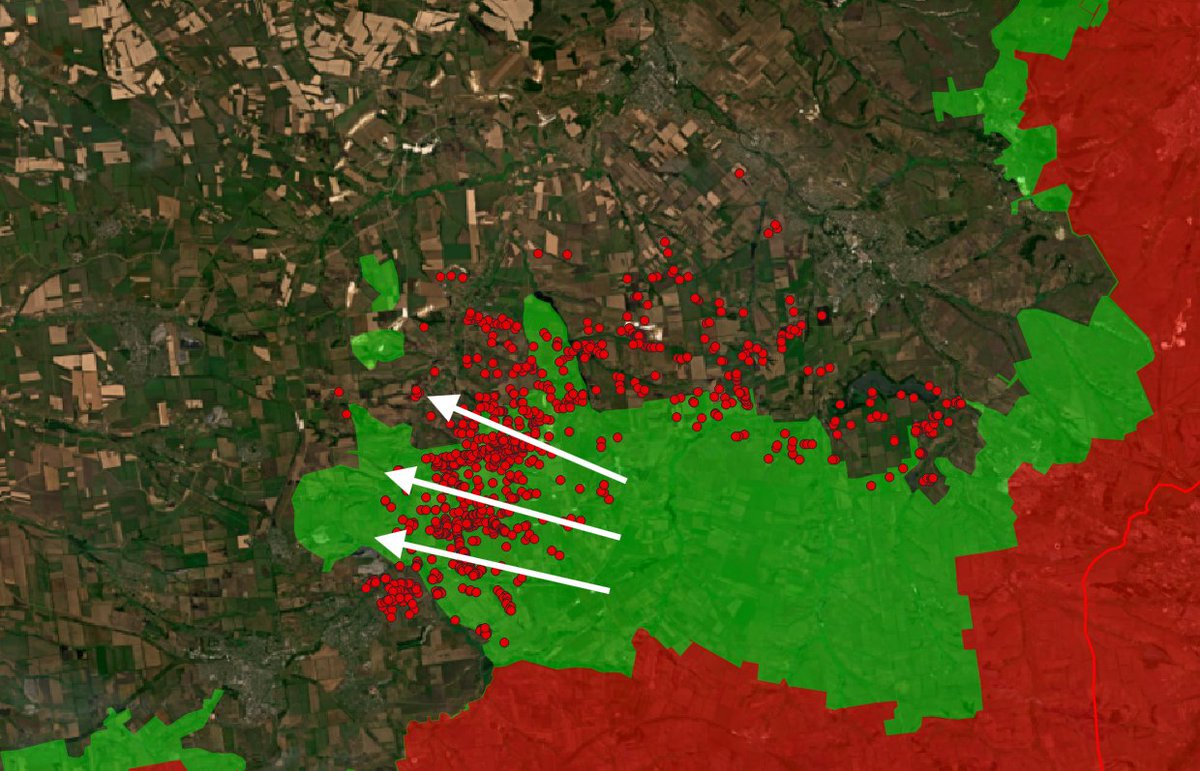
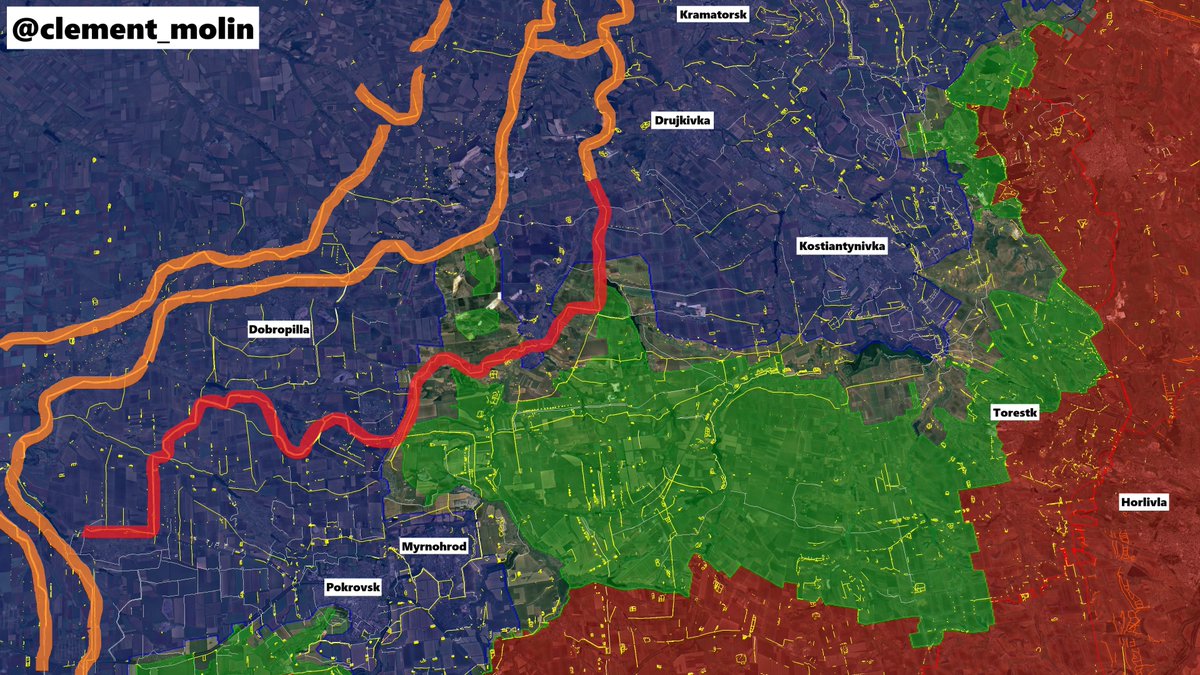
Take a look at this map and remember the colors. In the middle is Shakove, a point of resistance since 3 months ! Russia is trying to cut it from behind.
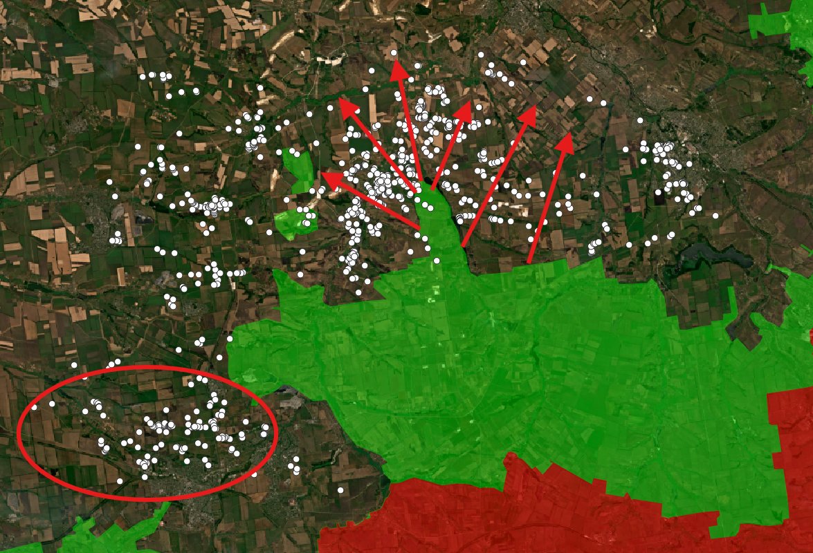
With the white and yellow dots, for most recent airstrikes, we can see the result of Dobropilla breakthrough.
With the white and yellow dots, for most recent airstrikes, we can see the result of Dobropilla breakthrough.

Everyday, people are telling me that russian army entered Pokrovsk and Kostiantynivka.
They didn't understand how the war is working. The frontline is not a line anymore and both sides are sending troops behind. With the winter coming, the lack of tree coverage will be decisive.
They didn't understand how the war is working. The frontline is not a line anymore and both sides are sending troops behind. With the winter coming, the lack of tree coverage will be decisive.
Of course, the situation of both cities is not very good. There is constant shelling of logistics and multiple drone strikes, as well as daily assaults.
However, Ukraine is still holding there. The situation is much worse in Zaporizhia, where Russia is pushing.
However, Ukraine is still holding there. The situation is much worse in Zaporizhia, where Russia is pushing.
During all the time they gained after the successful counter-offensives, Ukraine reinforced the Donbass line (The red one is not really part of it, but it's northern part is).
They started expanding the lines on the same model of 3 ditches, barbed wire and concealed trenches.
They started expanding the lines on the same model of 3 ditches, barbed wire and concealed trenches.
To explain, the Donbass line 2 was built before the other ones. It was later reinforced in some parts by the 1st one (or sometimes 0.5 because it is unfinished) and behind, a third line has been prepared, now being connected with the second.
In pink, all the new defenses !
In pink, all the new defenses !
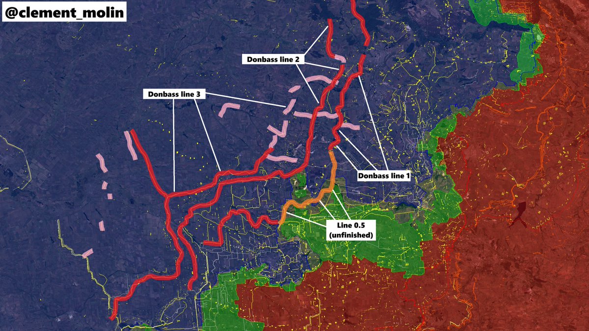
To make it more simple, here is a map with the 3 Donbass lines, and in pink the current work being done (my take, because the directions of the ditches can change).
We can see two west-east lines near Kramatorsk and 2 new long lines west of Donbass.
We can see two west-east lines near Kramatorsk and 2 new long lines west of Donbass.

In Zaporijia finally, two lines are being prepared east of the city in the context of faster progress by russian forces near Pokrovsk'e.
For now, it is only the begining, I have no idea how they will expand these defenses, but they should rather expand it fast !
For now, it is only the begining, I have no idea how they will expand these defenses, but they should rather expand it fast !

@Thorkill65 has been doing a very good job of analysing the frontline. He is also looking a lot at Sentinel's sattelite imageries to understand how the frontline is moving.
Here, the offensive is aiming at Drujkivka.
Here, the offensive is aiming at Drujkivka.
https://x.com/Thorkill65/status/1974512964238537098

Thanks for following this thread.
You can support my volunteer work here, especially for tracking russian airstrikes and ukrainian fortifications.
buymeacoffee.com/clement.molin
You can support my volunteer work here, especially for tracking russian airstrikes and ukrainian fortifications.
buymeacoffee.com/clement.molin
You may find some of my graphs and maps useful and interesting. You can obviously use them if you credit me @clement_molin
Don't forget to give a follow if you are not yet following and to put the "notification" on my profile.
Don't forget to give a follow if you are not yet following and to put the "notification" on my profile.


• • •
Missing some Tweet in this thread? You can try to
force a refresh