Ukraine Control Map Profile picture
Oct 13 16 tweets 5 min read Read on X
Daily Ukraine map thread for Monday 13th October 2025

Russian forces (Marines and attempted another large mechanized assault northeast of Pokrovsk today. Things did not appear to go well for the Russian forces. As of right now, the Ukrainian Unmanned Systems killboard for today alone is 8 tanks damaged, 2 destroyed, and 35 AFVs damaged, 9 destroyed.

Elsewhere, Ukrainian forces were geolocated in central Oleksiivka, Sumy, likely having taken the settlement back.

Feodosia oil and fuel depot was struck yet again last night and is still burning. Capacity should be below half now, as it's the second time it's been struck this month.Dobropillya direction as of 13th October 2025
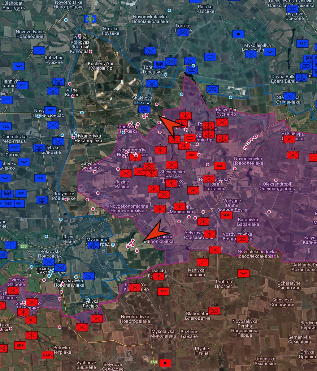
2/ Many Russian dismounts struck and dead near Novoekonomichne
Coordinates: 48.29820, 37.33324
Source:
3/ Destroyed Russian BMP-3 near Novoekonomichne
Coordinates: 48.297822, 37.332793
Source:
4/ Damaged / Abandoned Russian APCs near Shakhove, filmed by 1st Azov Corps
Coordinates: 48.459544, 37.37581
Source:
5/ Russian BMP-3 hits mine near Fedorivka, smokes and stationary
Coordinates: 48.38265, 37.30646
Source:
6/ Artan of GUR, on an armored vehicle, fired at the position where the Russian soldiers were located, covering the assault group during the landing. The enemy was repelled and the position was captured in area Serednie, Donetsk region, Ukraine
Coordinates: 49.118813, 37.693568
Source:
7/ Burning Russian MT-LB after 38th Marine drone strike east of Balahan
Coordinates: 48.286596, 37.339829
Source:
8/ DART drone takes out Russian substation in Rylsk
Coordinates: 51.565094, 34.663022
Source:
9/ 59th Assault Brigade FPV drone hit on a sad looking russian storm trooper west of Kotlyarivka, Donetsk
Coordinates: 48.150690, 36.889629
Source:
10/ 79th Air Assault destroy MT-LB near Balahan, Myrnohrad
Coordinates: 48.291379, 37.323901
Source:
11/ Strange russian assault outside of Myrnohrad, Donetsk. Circling Russian vehicle throws a Russian out onto the ground, near Myrnohrad as it does circles. Filmed by 79th Air Assault
Coordinates: 48.293637, 37.327958
Source:
12/ Two civilians were killed as a result of a Russian FPV drone attack on a car in Preobrazhenka.
Coordinates: 47.575073, 35.807404
Source:
13/ 33rd Assault Regiment and 24th Assault Battalion Aidar raise flag in Mali Shcherbaky
Coordinates: 47.550803,35.549975
Source:
14/ Explosions along a road used by Russian soldiers filmed by the 425th Skala regiment of Ukraine, Russian casualties shown.
Coordinates: 48.37947, 37.26507
Source:
15/ 6th Special Purpose Battalion, 12th Special Purpose Brigade "Azov" hits a Russian soldier on a motorcycle with a FPV drone in Shcherbynivka
Coordinates: 48.398264, 37.784948
Source:
16/ Feodosia oil depot burning after Ukrainian drone strike
Coordinates: 45.047068, 35.356201
Source:

• • •

Missing some Tweet in this thread? You can try to force a refresh
 

Keep Current with Ukraine Control Map

Ukraine Control Map Profile picture

Stay in touch and get notified when new unrolls are available from this author!

Read all threads

This Thread may be Removed Anytime!

PDF

Twitter may remove this content at anytime! Save it as PDF for later use!

Try unrolling a thread yourself!

how to unroll video
  1. Follow @ThreadReaderApp to mention us!

  2. From a Twitter thread mention us with a keyword "unroll"
@threadreaderapp unroll

Practice here first or read more on our help page!

More from @UAControlMap

Sep 26
Daily Ukraine map thread for Friday 26th September 2025

Highlights: Afipsky refinery hit last night by Ukrainian drones. It's the third time it's been struck with visible damage since this latest refinery campaign began in August.

Russian forces are shown to have advanced near Siversk, infiltrating near Dronivka and north of the settlement itself.

Russian fuel train derailed after leaving Belarus, and hitting truck at crossing. Sabotage or accident, you decide.

Map: uacontrolmap.comSiversk direction as of 26th Sept 2025
2/ Russian fuel truck collides with truck and derails near Ryzhikovo, Smolensk
Coordinates: 54.88382, 31.30416
Source:
3/ PoV of flames at Afipsky refinery
Coordinates: 44.884898, 38.821780
Source:
Read 12 tweets
Sep 25
Daily Ukraine map thread for Thursday 25th September 2025

Highlights: Very little to report on the battlefield, bar Russia grinding slowly forward in numerous areas, but glacially slow and for a horrifically high cost. Key areas remain at Kupiansk in the Kupiansk direction, at Yampil and Shandryholove in the Lyman direction, at Siversk in the Siversk direction and south of Kostyantynivka in the eponymous direction. NE of Pokrovsk in the Dobropillya area remains a grey area despite it being six weeks later, and the Russian naval infantry has entered the fight doing what they do - head on.

Continued Russian failures to do much of anything on the battlefield have allowed time for Ukraine to improve their drone programme, which is reaping dividends at the moment. Not dividends for the oligarches in charge of oil refineries however!

Prymary drones of the HUR continue to strike at Crimea, with an An-26 at Kacha airfield hit, causing a fire, whilst also striking radars near the coast. There is nothing to suggest these strikes will diminish.

Map: uacontrolmap.com30-Blue An-26 destroyed at Kacha air base, Crimea
30-Blue An-26 destroyed at Kacha air base, Crimea
2/ An-26 transport plane 30-Blue attacked by an Ukrainian Prymary drone at Kacha, and burnt down
Coordinates: 44.770109, 33.571173
Source: x.com/99Dominik_/sta… and x.com/tom_bike/statu…
3/ Prymary GUR hit Russian coastal radar MR-10M1 "Mys M1" in Cape Tarkhankut, Crimea, Ukraine
Coordinates: 45.346832, 32.496315
Source: x.com/auditor_ya/sta… and x.com/Lorenzo6527884…
Read 11 tweets
Sep 7
Daily Ukraine map thread for Saturday 6th September 2025

Highlights: Geolocations show a Russian advance beyond Shandryholove to the road near Drobysheve before being halted.

Russian mechanized assault towards Myrnohrad spotted, five vehicles claimed destroyed.

We've adjusted numerous icons to further reflect the changing nature of the war. Refineries are added, as are many of the new Corps units. Many smaller older unit cards have been folded into their parent units and transferred to the archive box. Many thanks to @Davommeh for their high res insignias.

Map: uacontrolmap.comLyman direction as of 6th September 2025
2/ A Russian soldier was struck by a Ukrainian FPV drone in Leontovychi, Donetsk
Coordinates: 48.253224, 37.123882
Source:
3/ Russian strike on Senkove. Claimed to be Kh-39 LMUR on UAV launcher
Coordinates: 49.522645, 37.662131
Source:
Read 15 tweets
Sep 5
Daily Ukraine map thread for 1st to 5th September 2025

Highlights: We've returned, and will focus on the changes that occurred on the front whilst away.

At the Kreminna / Lyman direction, fighting continues over Torske and Zarichne, whilst the northern flank continues to fail as Russian forces approach Drobysheve to cut the route - which is well and truly interdicted by drone at this point too. There is also heavy fighting near Serebryanka on the Siversk side of the river as Russian forces continuously attack there.

At Kupiansk, Russian infiltrators raised a flag in the centre of the town before being hit by a drone. We've warned numerous times that the Ukrainians saying the situation under control in this area are lying about the situation, but nothing seems to get done. Regardless, the north half of the town is a grey area and threatens the east bank substantially at this point due to lack of action.

In Western Donetsk and into Dnipropetrovsk oblasts, Russian forces continue to advance here, raising a flag in Novoselivka, whilst flag raising groups occur on both sides near Dachne and Filiya.

In Western Zaporizhia, a recent Russian mechanized assault almost reached Novodanylivka before being destroyed. Another attack occurred near Mala Tokmachka, but went about as well as the previous attacks with AFVs destroyed. Russia forces continue to attack on foot towards Stepnohirsk on the edge of the old reservoir.

At Pokrovsk, Ukrainian forces captured numerous Russian PoWs when they attacked into Boikivka, as well as retook Udachne. Russian forces attacked from Novoekonomischne into Myrnohrad but appear repelled. Note the Russian Naval Infantry force shift in this region.

At Kostyantynivka, Russian forces continue to advance with infiltration groups almost reaching the town.

In more optimistic news for Ukraine, the long range strike campaign has definitely improved. Last night Ryazan refinery was hit again, and fuel storage in Luhansk was also struck. Numerous radar sites and AD sites were struck during August as well.

Map: uacontrolmap.comLyman direction as of 5th Sept 2025
Kupiansk direction as of 5th Sept 2025
West Donetsk direction as of 5th Sept 2025
West Zaporizhia / Orikhiv direction as of 5th Sept 2025
2/ 425th Assault Regiment "Skala" shows Ukrainian flag hoisted in Novoekonomischne

Coordinates: 48.325523, 37.329632

Source:
3/ Ukrainian forces moving in central Novoekonomichne, Donetsk Oblast

Coordinates: 48.325363, 37.329634

Source:
Read 25 tweets
Aug 9
Daily Ukraine map thread for Saturday 9th August 2025

Highlights: Yet another Russian drone strike on a civilian bus in Kherson area results in dead and many injured.

Russian forces advance slightly at Shcherbynivka in the Toretsk direction, and also northeast of Pokrovsk. The Lyman direction also remains dangerous, we have advanced Russian control near Kolodyazi by half a treeline.

Map: uacontrolmap.comToretsk as of 9th August 2025
2/ Civilian casualties after a Russian drone attack on a bus in Kherson Oblast.
Coordinates: 46.733266, 32.705379
Source:
3/ 60th Mech shell Russian position west of Kolodyazi
Coordinates: 49.091863,37.864838
Source: t.me/GridScope/175
Read 8 tweets
Jul 26
Daily Ukraine map thread for Saturday 26th July 2025

Highlights: Few changes on the ground today. Russian flag raise in Zelenyi Hai, west Donetsk, as well as in Maliivka, Dnipropetrovsk oblast, both shown below.

Russian forces also infiltrated the Kreminna forest and raised a flag three kilometers deep.

HUR posts Su-27UB at Armavir sabotaged and set alight, damaging it. Honestly, they'd have better luck with sledge hammers than this amateur fire starting attempts.

Map: uacontrolmap.comWest Donetsk as of 26th July 2025
2/8 336th Naval Infantry Brigade raise flag in Maliivka, Dnipropetrovsk oblast
Coordinates: 47.92425, 36.63164
Source:
3/8 36th Motor Rifle Brigade raise flags in Zelenyi Hai, Velyka Novosilka direction
Coordinates: 48.07699, 36.64941
Source:
Read 8 tweets

Did Thread Reader help you today?

Support us! We are indie developers!


This site is made by just two indie developers on a laptop doing marketing, support and development! Read more about the story.

Become a Premium Member ($3/month or $30/year) and get exclusive features!

Become Premium

Don't want to be a Premium member but still want to support us?

Make a small donation by buying us coffee ($5) or help with server cost ($10)

Donate via Paypal

Or Donate anonymously using crypto!

Ethereum

0xfe58350B80634f60Fa6Dc149a72b4DFbc17D341E copy

Bitcoin

3ATGMxNzCUFzxpMCHL5sWSt4DVtS8UqXpi copy

Thank you for your support!

Follow Us!

:(