Seen from Kyiv 🇺🇦, the last Donbas fortress
Most maps of the war in Ukraine are showing the same perspective and the same informations. Here, you will see rivers, railways, fortifications, forests...
20 surprising maps on the war in Ukraine
🧵THREAD🧵1/23 ⬇️⬇️⬇️
Most maps of the war in Ukraine are showing the same perspective and the same informations. Here, you will see rivers, railways, fortifications, forests...
20 surprising maps on the war in Ukraine
🧵THREAD🧵1/23 ⬇️⬇️⬇️

1- The frontline in december 2022
Days after the end of the Kharkiv and Kherson counter-offensive, russian army was controling less than 50% of the Donetsk region. The battle for Bakhmut just started and Donetsk was still threatened.
This map may seem old or out of context, but it actually helps to better understand the evolution of the Russian offensives in the Donbas.
One must put oneself in the shoes of the political and military decision-makers in Moscow: they had failed to take Kyiv, Kharkiv, or Odessa, to force Ukraine to capitulate, they had been humiliated in Kharkiv, and had to retreat from Kherson. It was therefore the full force of Soviet firepower that was deployed in the east of the country and became ruthless in the ensuing battles, sometimes at the cost of very heavy losses, as at Bakhmut and Avdiivka.

2- Three years in Donbas
The last 3 years of war have mainly been fought in Donbass.
After very slow and costly advances for the Russian army in Bakhmut and Avdiivka in 2023, the offensive towards Pokrovsk accelerated in 2024, with the Ukrainian army surrendering the best fortifications in the Donetsk suburbs.
The main Russian victory took place in South Donetsk, now completely under Russian control, but many months of campaigning remain, at the current pace, between one and two years to capture the last strongholds in North Donetsk. These three years have seen a constant offensive, the gradual depletion of Ukrainian reserves, and the deaths of hundreds of thousands of soldiers in a relentless war of attrition. On paper, the Ukrainian army has held its ground and not yielded, despite local setbacks. It remains to be seen whether it will maintain its endurance.

3- Donbas progression
🔴2021
🟠2022
🟡2023
🟡2024
⚪️2025
⚫️Administrative Border
Here is the progress of russian forces in Donbass since february 24th 2022. We can see how slow it has been and the acceleration in 2024 and 2025. There is still a long path to go for Russia.
🔴2021
🟠2022
🟡2023
🟡2024
⚪️2025
⚫️Administrative Border
Here is the progress of russian forces in Donbass since february 24th 2022. We can see how slow it has been and the acceleration in 2024 and 2025. There is still a long path to go for Russia.

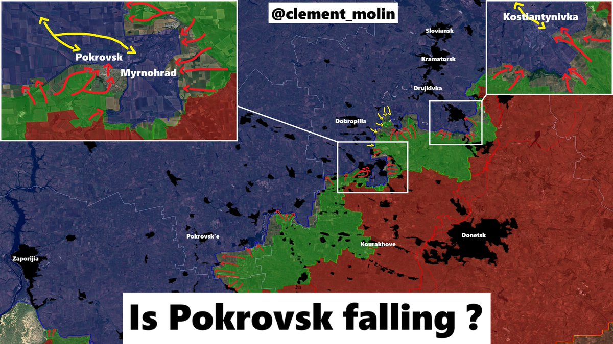
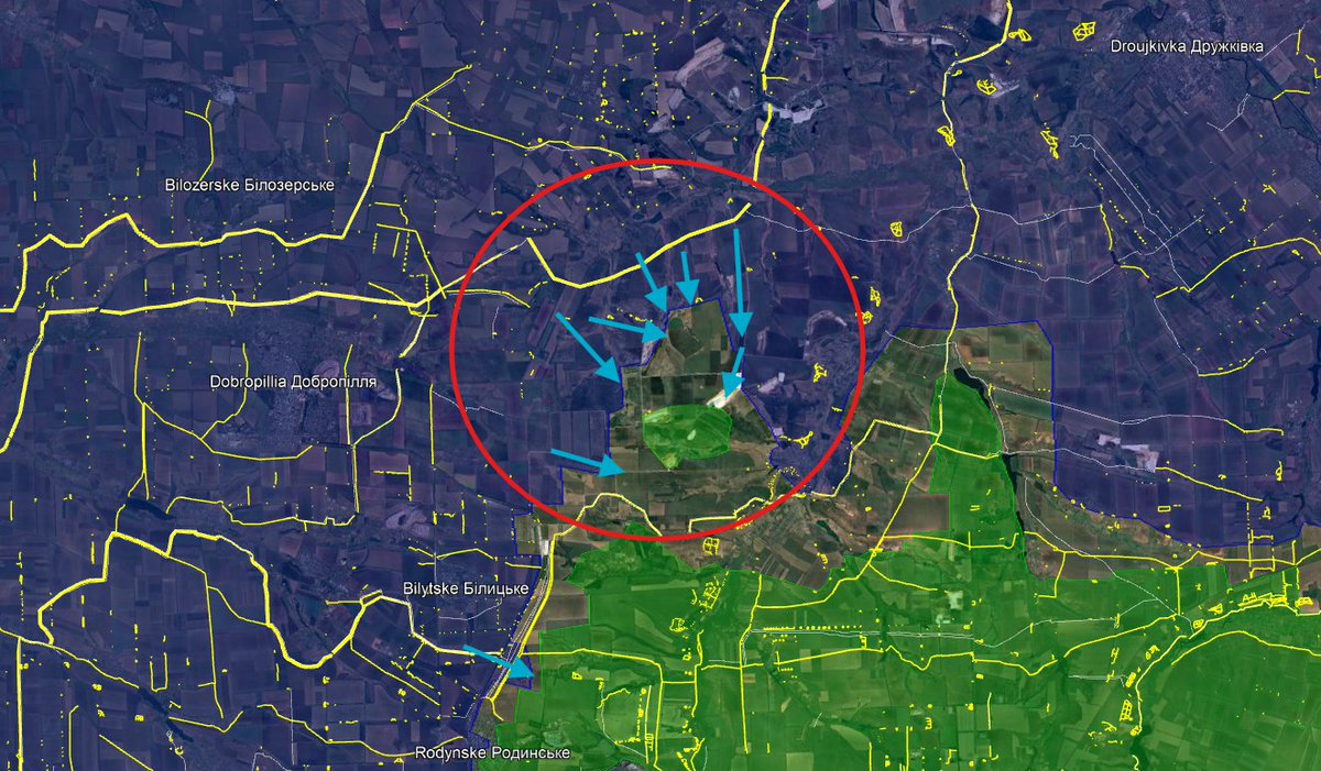
4- One last stand
Seen from Kyiv perspective, the ukrainian Donbass is now much smaller than before, with Pokrovsk and Myrnohrad currently falling, the 4 remaining cities around Kramatorsk will be the last stand for Ukraine in Donbass.
This map may be disturbing isn't it ?
Seen from Kyiv perspective, the ukrainian Donbass is now much smaller than before, with Pokrovsk and Myrnohrad currently falling, the 4 remaining cities around Kramatorsk will be the last stand for Ukraine in Donbass.
This map may be disturbing isn't it ?

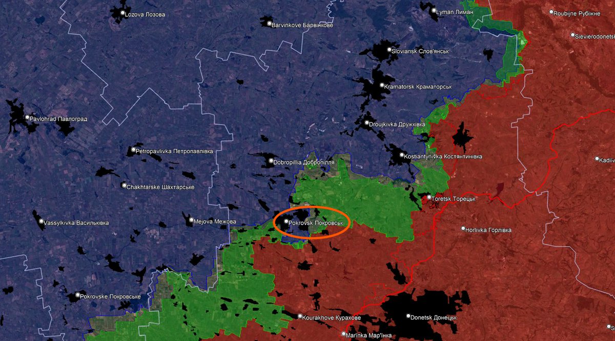
5- The last Donbas fortress
As you saw on the first picture of this thread, with the fortification overlay, we can clearly see how much has been built in front of the remaning cities and behind them.
Every additional month is Donbas is more fortifications behind.
As you saw on the first picture of this thread, with the fortification overlay, we can clearly see how much has been built in front of the remaning cities and behind them.
Every additional month is Donbas is more fortifications behind.

6- The new Donbas line method
In 2025, Ukraine started digging new style of defenses, with :
-3 ditches filled with barbed wire
-1 dragon teeths with barbed wire on top
-2 barbed wire row
I've called these lines the "New Donbas Lines", because it started in the western part of Donetsk oblast.
Currently, we have two to three such lines of defense in the Donbas, some of which have already proven their worth. They are now being deployed throughout the country, for example, towards Kharkiv, Sumy, and Zaporizhzhia.
Looking at this map, we also notice that almost all of the fortifications face east—curious, isn't it?

7- Old and new fortifications
In red, you can see the new fortifications on the "New Donbas Lin" style. In yellow, you can find old fortifications (some are obsolete) and new ones that are still very useful, especially in the case of anti-tank ditches and anti-infantry obstacles
In red, you can see the new fortifications on the "New Donbas Lin" style. In yellow, you can find old fortifications (some are obsolete) and new ones that are still very useful, especially in the case of anti-tank ditches and anti-infantry obstacles

8- Railway logistics
After for maps where the north was on the left, we are back at normal. With the end of Pokrovsk as the main Donbas railhub, new cities are being used for this purpose.
They became, thus, strategic cities and objectives for Russia. We have Lozova (the Kramatorsk railway station just closed, so it may become the terminus), Pavlohrad and Zaporizhia.

9- Road logistics
The road logistics have also changed a lot recently. Pokrovsk has been replaced by smaller cities playing as frontline logistics hubs. Pavlohrad and Lozova are again playing the role of main supply hubs, together with Zaporizhia.
The road logistics have also changed a lot recently. Pokrovsk has been replaced by smaller cities playing as frontline logistics hubs. Pavlohrad and Lozova are again playing the role of main supply hubs, together with Zaporizhia.

10- Dnipro and Zaporizhia soon threatened ?
The Russian push towards the Dnipropetrovsk region and the initial advance towards Zaporizhzhia raise fears of a long-term threat to the two major cities in central Ukraine.
The immediate concern is not so much the fall of these cities, but rather the gradual neutralization of their capacity as logistics hubs, both rail and road, their strategic industries, and their few remaining bridges over the Dnipro River. Recently, the first modern fortifications have been erected east of Zaporizhzhia, along three lines currently under construction.

11- 23 bridges on the Dnipro river
Ukrainian logistics are severely hampered by the Dnieper River, a vast waterway, spanned between Kyiv and Zaporizhzhia (the Kherson bridges having been destroyed) by only 23 bridges (4 of which are solely railway bridges, and a dozen mixed-use bridges), 5 of which are dams and therefore difficult to destroy.
However, if the dozen or so bridges in Zaporizhzhia and the Dnieper River were partially or totally destroyed, Ukrainian logistics would be completely crippled. This is a crucial point to bear in mind.

12- Across the Dnipro
Ukrainian strategic reserves are thus positioned west of the Dnieper River and are not intended for deployment in the east. They are there to cover the rear, provide logistics, air defense, training, border security, and so on. In total, it is likely that hundreds of thousands of mobilized personnel (including, unfortunately, those with the highest social and intellectual standing) are being kept on this side of the Dnieper for various reasons.
They have, in particular, a colossal task: maintaining air defenses, guarding the borders with Belarus and Transnistria, and securing the coasts along the Dnieper River and the Black Sea.

13- An encircled Ukraine
De-zooming is also very important, on this map, you can see that Ukraine is encircled on all sides, it has to defend all these borders and frontlines...
It also gives us a snapshot of the potential future Ukraine...
De-zooming is also very important, on this map, you can see that Ukraine is encircled on all sides, it has to defend all these borders and frontlines...
It also gives us a snapshot of the potential future Ukraine...

14- Between Forest and river
The Oskil front is also quite active. When looking at a map, one doesn't necessarily notice two very important landscape features:
Two long, wide rivers (the Donets and the Oskil) and the dense surrounding forests. The Oskil River is a significant natural barrier (not impossible to cross, certainly, but it gives the defender an advantage, while also complicating their logistics). The Siverski Donets River, on the other hand, was the main Ukrainian line of defense in 2022.
The Ukrainian army initially withdrew along the main cities (Sievierodonetsk, Kreminna, Lyman, Izium, Balaklya, Chuihuiv, etc.) before counter-attacking. With the second battle of Lyman about to begin, we are right in the middle of this situation. The river also offers very large forests, which allow for the concealment of equipment and troops and provoke trench warfare, as in the Serebyanka Forest. From an ecological point of view, the fighting in this protected natural area is absolutely devastating for the flora and fauna.

15- Northern forests
Talking about forests, we should'nt forget about the large forests in northern Ukraine, where troops, fortifications, air defense an other assets can be easily hidden.
It would also complicate any offensive, but is allowing DRG infiltration.
Talking about forests, we should'nt forget about the large forests in northern Ukraine, where troops, fortifications, air defense an other assets can be easily hidden.
It would also complicate any offensive, but is allowing DRG infiltration.

16- 2024-2025
We didn't look that much into russian perspective, this time, we can see in green all the russian progress in 2024 and in 2025. Interesting right ?
We didn't look that much into russian perspective, this time, we can see in green all the russian progress in 2024 and in 2025. Interesting right ?

17- Remaining fortifications
With the same point of view (and obviously, you need to click to zoom in), we can see in red all the remaining ukrainian fortifications in eastern, southern and north-eastern Ukraine.
With the same point of view (and obviously, you need to click to zoom in), we can see in red all the remaining ukrainian fortifications in eastern, southern and north-eastern Ukraine.

18- Cities, fortifications and rivers east of the Dnipro
Another map, this one on the highest resoltion possible, showing the view from the Dnipro river
Another map, this one on the highest resoltion possible, showing the view from the Dnipro river

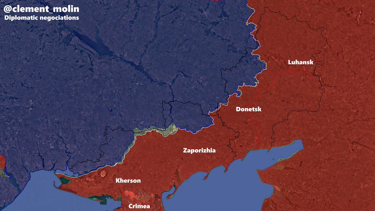
19- Diplomatic negociations :
On this map, you can see the borders of the 4 "annexed" oblasts, the black line⚫️ is what Putin official wants. The red line🔴 iw what he had before the war and the white line ⚪️ is what he currently has.
On this map, you can see the borders of the 4 "annexed" oblasts, the black line⚫️ is what Putin official wants. The red line🔴 iw what he had before the war and the white line ⚪️ is what he currently has.
20- Ukrainian and Russian units
For the last map, I will show you the excellent work of @UAControlMap with all the deployed units of both sides.
Always remember more than 80% of the russian army is currently in Ukraine.
For the last map, I will show you the excellent work of @UAControlMap with all the deployed units of both sides.
Always remember more than 80% of the russian army is currently in Ukraine.

Here is the end of this thread. Tell me which maps do you prefer here with the 3 numbers (for example, i will say 5/3/14).
I reached 80 000 followers, thank you very much ! Don't forget to follow me on LinkedIn.
linkedin.com/posts/cl%C3%A9…
I reached 80 000 followers, thank you very much ! Don't forget to follow me on LinkedIn.
linkedin.com/posts/cl%C3%A9…
If you want to support me to continue making maps and analysis like this, you can do it here :
However, the most important is to follow my account and ❤️🔃, thank you !buymeacoffee.com/clement.molin
However, the most important is to follow my account and ❤️🔃, thank you !buymeacoffee.com/clement.molin
• • •
Missing some Tweet in this thread? You can try to
force a refresh