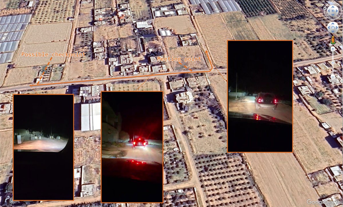
Geolocation| An Israeli drone hits and injures an activist during an olive harvest near the Revava settlement in Deir Istiya, Salfit Governorate, occupied #WestBank
32.128986, 35.118375
🗓️ 4 Nov. 2025
@GeoConfirmed Later, 2 Israelis wearing military uniforms and both armed with a rifle arrived from the NE, took the drone and fired a shot in the air.
Using Govmap, the footage can be matched to the same location. x.com/MatanGolanPhot…
(1/2) x.com/nurityohanan/s… x.com/omdimbeyachad/…
• • •
Missing some Tweet in this thread? You can try to
force a refresh
Geolocation| A livestream posted by Popular Forces militia leader Yasser Abu Shabab shows armed Palestinians driving through the Al-Shoka area of eastern Rafah, South #Gaza
Start: 31.268471, 34.288884
End: 31.266688, 34.290216
🗓️13 Oct.
This is in the same area as were previous footage related to the milita has been geolocated to.
h/t @Arabosint & @fdov21
The video starts at a possible checkpoint and later passes another group of armed Palestinians.
Source: facebook.com/reel/148235123… x.com/Arabosint/stat…
@Arabosint @fdov21 A great and recent Sky News investigation by @_BvdM & @SamDoak5 also looks further into the milita.
In the livestream geolocated above, several cars are visible too.
Article: news.sky.com/story/guns-cas… x.com/_BvdM/status/1…
🧵Geolocations related to a Hamas video showing Israeli hostage Guy Gilboa-Dalal (and later Alon Ohel) being driven around in western Gaza City, Northern #Gaza 1/
Geolocation| (0:04-1:21) PRCS medics recover casualties, including killed children, after a reported Israeli airstrike near 8th Street, Zeitoun neighborhood, Gaza City, Northern #Gaza
9 people were reportedly killed.
31.495095, 34.445670
(1:45-1:57) The casualties were brought to the Al-Shifa Hospital where another video also shows at least 6 killed children (some also visible in PRCS video).
Geolocation: 31.523163, 34.443548
The number on the ambulance also matches between both videos. instagram.com/p/DNNG8wYsX82/
Geolocation| An Israeli settler fires at least 2 gunshots near Palestinians and activists in Khirbet Umm Al-Khair next to the Carmel settlement, Masafer Yatta, occupied #WestBank
A Palestinian was killed in the attack.
31.432027, 35.185000
At least 2 shots are visible in the video. While the second appears to have been in the air, the first is lower.
At the end of the video, the videographer runs toward people screaming, possible indicating the location of a casualty. This is the same direction as the second shot.
Geolocation of an advertisement posted by Rafael showing a presumed Israeli SPIKE Firefly loitering munition attack on a Palestinian walking in the Al-Tawam neighborhood, North #Gaza
31.546022, 34.482736
Based on 2 Google Earth satellite images the video appears to have been taken between 4 June 2024 and 1 December 2024.
Possible changes are visible in the area on Sentinel satellite imagery from Nov. 2024.
The 1 Dec. Google Earth image shows Israeli military vehicles and multiple staging area's less than 1km from the location of the attack.
@GeoConfirmed Israeli forces at a, reportedly closed, checkpoint on the road between Hableh and Qalqilya, Qalqilya Governorate.
32.172399, 34.975619
Street-level: Mapillary
Photo: 2/ t.me/nablusnews2/10…
Closed gate and Israeli soldiers stopping a Palestinian on a main road near Qarawat Bani Hassan, Salfit Governorate.
A video shows people running amid audible gunfire.
32.117734, 35.103034
Photo: t.me/nablusnews2/10…
Video: x.com/AJA_Palestine/… 3/ x.com/qudsn/status/1…