Weekend Ukraine map thread for Sunday 9th November 2025
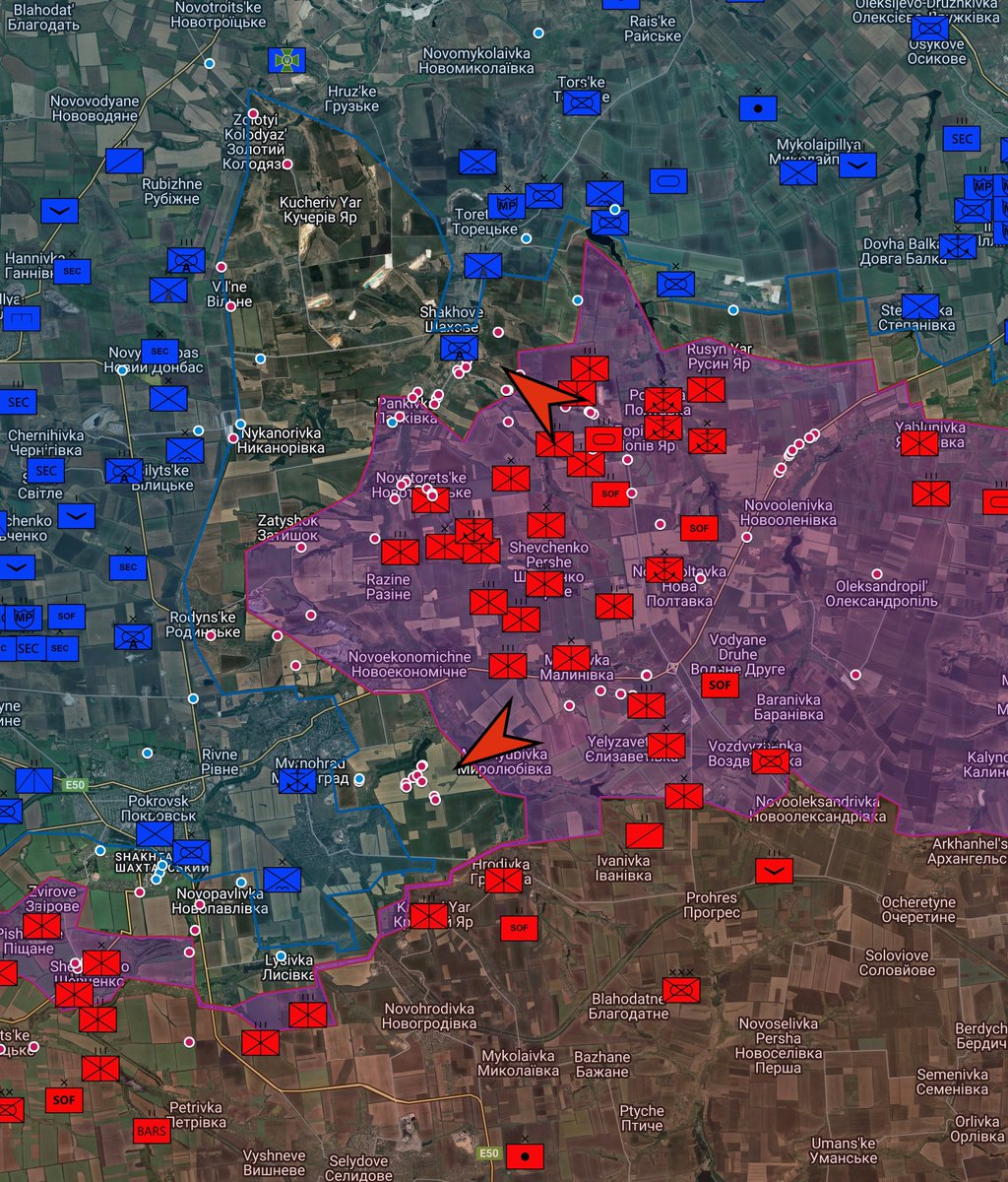
Highlights: Fog hampers actions around Pokrovsk, which remains contested.
Ukrainian forces sighted back in Chasiv Yar, as the Russian Alfa drone unit of the 28th Motor Rifle Regiment video shows. Needless to say, they quickly deleted the video showing the Ukrainian advance, but not before it was geolocated and stored. (Map 1)
Russian forces raise a few flags in Rybne, over the Yanchur river in east Zaporizhia. (Map 2)
Russian 123rd Motor Rifle of the 3rd Army (LPR) assaults a trench just outside Siversk. (Map 3)
Russian strikes disable many Ukrainian power plants over the weekend across the country, whilst this year Ukraine can actually strike back, and disabled a few Russian ones.


2/ SSO FP-2 drones hit S-400 launcher in Uiutne, Crimea, from October 6th
Coordinates: 45.519024, 34.564426
Source:
Coordinates: 45.519024, 34.564426
Source:
https://x.com/99Dominik_/status/1987094211364335979
3/ A Russian FPV drone struck a vehicle of the humanitarian mission "Proliska" in Kostyantynivka.
Coordinates: 48.550690, 37.635644
Source:
Coordinates: 48.550690, 37.635644
Source:
https://x.com/99Dominik_/status/1987105779397144686
4/ SSO FP-2 drone strike on ammunition depot in Udachne, Crimea
Coordinates: 45.392598,34.280232
Source:
Coordinates: 45.392598,34.280232
Source:
https://x.com/cyber_boroshno/status/1987091877313540361
5/ Russian troops assault and clear Ukrainian position east of Pischane
Coordinates: 49.66531, 37.81246
Source: x.com/richardzai3858… and x.com/Map_Hargoo/sta…
Coordinates: 49.66531, 37.81246
Source: x.com/richardzai3858… and x.com/Map_Hargoo/sta…
6/ A Russian BM-21 Grad was destroyed by a Ukrainian FPV drone in Pokrovs'ke, east of Bakhmut by 53rd Mech Signum
Coordinates: 48.608706, 38.149387
Source:
Coordinates: 48.608706, 38.149387
Source:
https://x.com/99Dominik_/status/1987179216392364374
7/ Russian Alfa (28th Motor Rifle Regiment) drone drop in S Chasiv Yar
Coordinates: 48.563319, 37.830936
Source:
Coordinates: 48.563319, 37.830936
Source:
https://x.com/Bielitzling/status/1987310286936670263
8/ Hornets of Dovbush of the 68th Jager Brigade strikes two Russian soldiers walking near the rails in Pokrovsk, Donetsk Oblast
Coordinates: 48.288338, 37.156260
Source:
Coordinates: 48.288338, 37.156260
Source:
https://x.com/Bielitzling/status/1987220638474621286
9/ Ukrainian drone strikes in south Kupiansk
Coordinates: 49.699125, 37.601900
Source:
Coordinates: 49.699125, 37.601900
Source:
https://x.com/Bielitzling/status/1987331442482028859
10/ 81st Apachi hits Russian dugout in Serebryanka
Coordinates: 48.9218476, 38.1365782
Source:
Coordinates: 48.9218476, 38.1365782
Source:
https://x.com/MaxximOSINT/status/1987515769534521679
11/ The power substation T-24 in Taganrog is on fire, officially assumed to be the result of a short circuit.
Coordinates: 47.20972, 38.88211
Source:
Coordinates: 47.20972, 38.88211
Source:
https://x.com/blinzka/status/1987488411414913472
12/ Russian 37th Motor Rifle Brigade raise flags in Ribne
Coordinates: 47.812340,36.338256
Source:
Coordinates: 47.812340,36.338256
Source:
https://x.com/richardzai38580/status/1987435712661364988
13/ Voronezh TPP hit by Ukrainian strike, aftermath
Coordinates: 51.6245902, 39.2279120
Source:
Coordinates: 51.6245902, 39.2279120
Source:
https://x.com/99Dominik_/status/1987409356988817833
14/ Biomass power plant struck in Koryukivka, Chernihiv
Coordinates: 51.774451, 32.219860
Source:
Coordinates: 51.774451, 32.219860
Source:
https://x.com/99Dominik_/status/1987548440193024011
15/ Fire in the area of Zmiivska thermal power plant after Russian strikes.
Coordinates: 49.590498, 36.525869
Source:
Coordinates: 49.590498, 36.525869
Source:
https://x.com/3_bm15/status/1987550767448723891
• • •
Missing some Tweet in this thread? You can try to
force a refresh