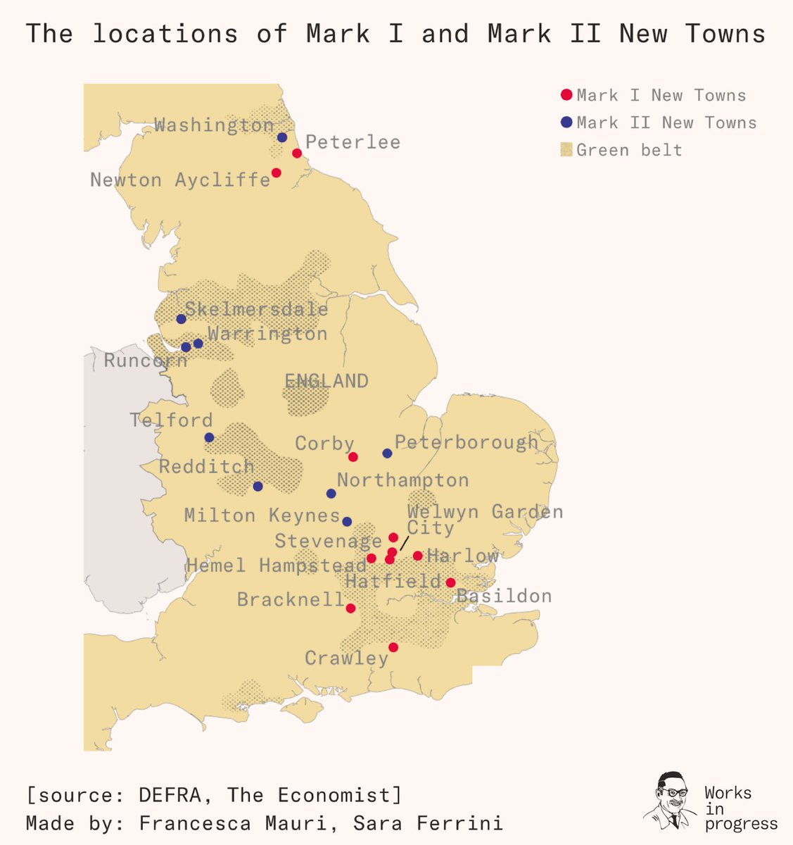
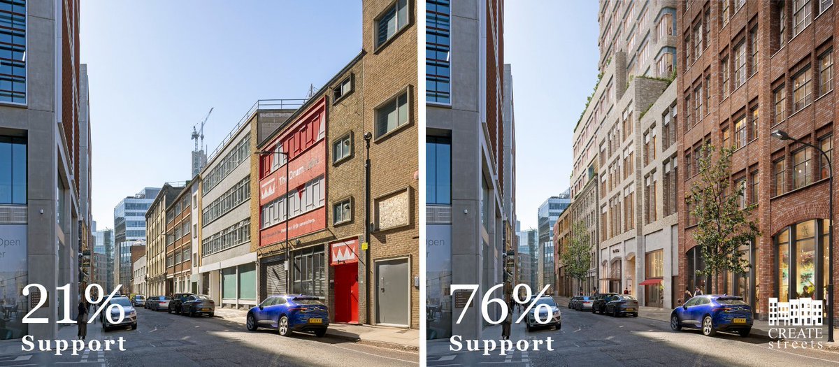
Thread of highlights from @Michael_J_Hil's excellent piece on Hackney Planning Dept's rationale for rejecting the hugely popular densification scheme 'Shoreditch Works', which would create space for 4,000 jobs on brownfield sites in central London.
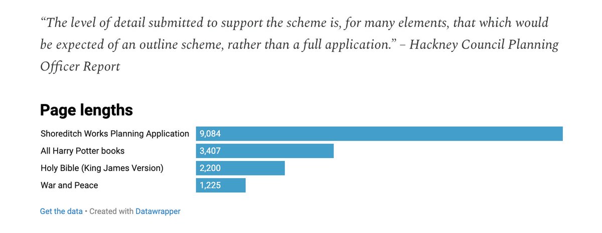
@Michael_J_Hil Although the planning application is some seven times longer than War and Peace and hundreds of times longer than early twentieth-century planning applications, the Dept considers it to be too short.
@Michael_J_Hil Parts of the development would be overshadowed by other parts of the development.
@Michael_J_Hil The developers have not provided enough evidence that the development will reduce greenhouse gas emissions, although there is overwhelming reason to believe it will.
@Michael_J_Hil The development is too weighted towards offices, although Hackney itself has designated the site a 'Priority Office Area'.
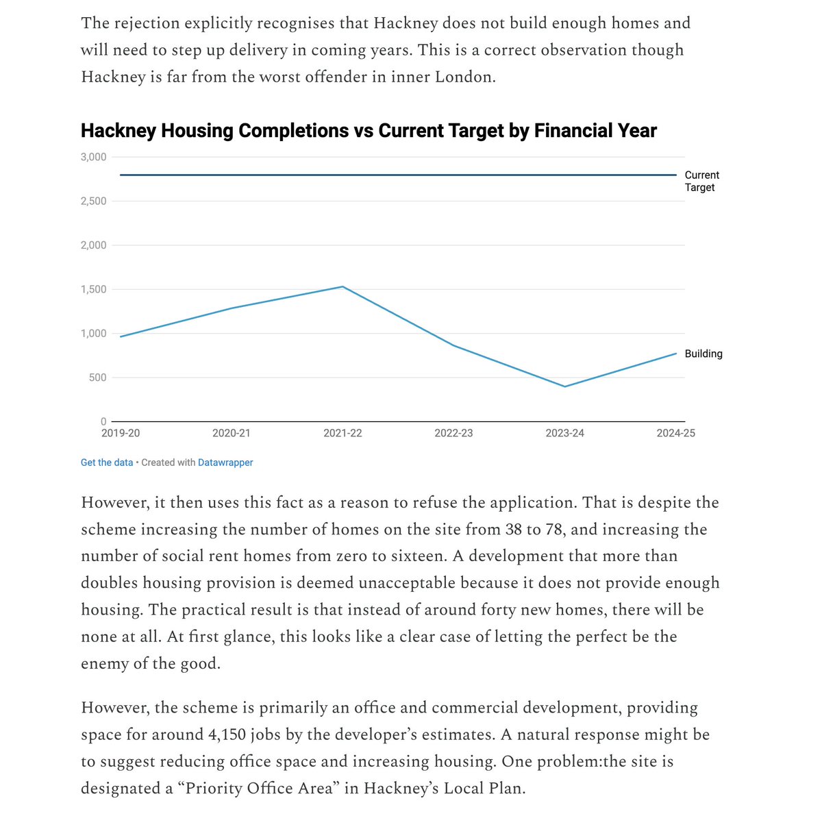
@Michael_J_Hil The proposed buildings are too large, but also insufficient housing and affordable workspace is created.
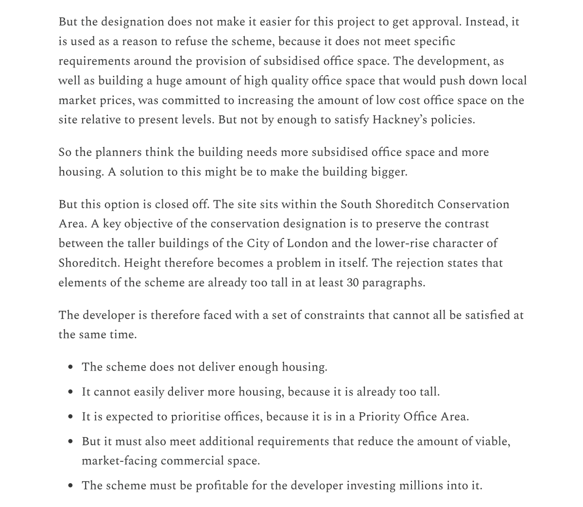
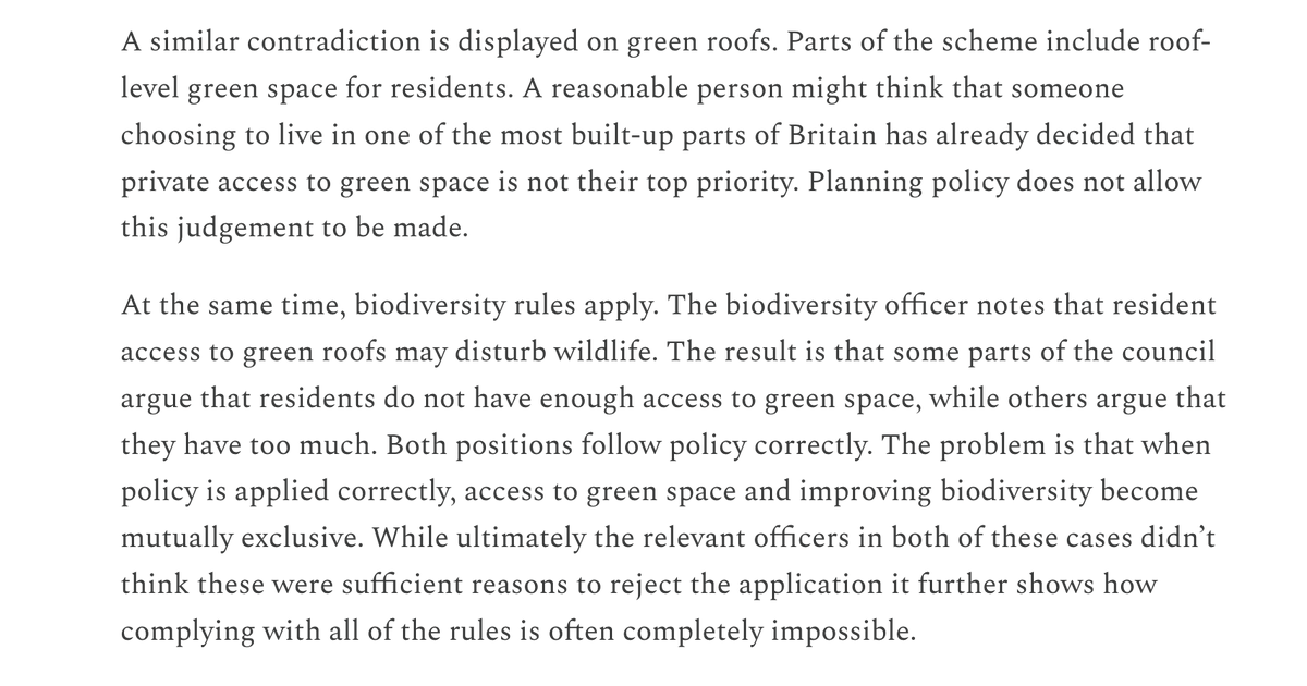
@Michael_J_Hil The building has too many green roofs and not enough green roofs.
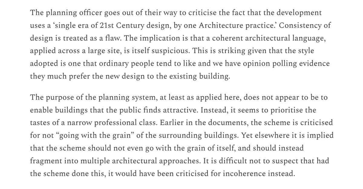
@Michael_J_Hil The architecture is too harmonious and not harmonious enough.
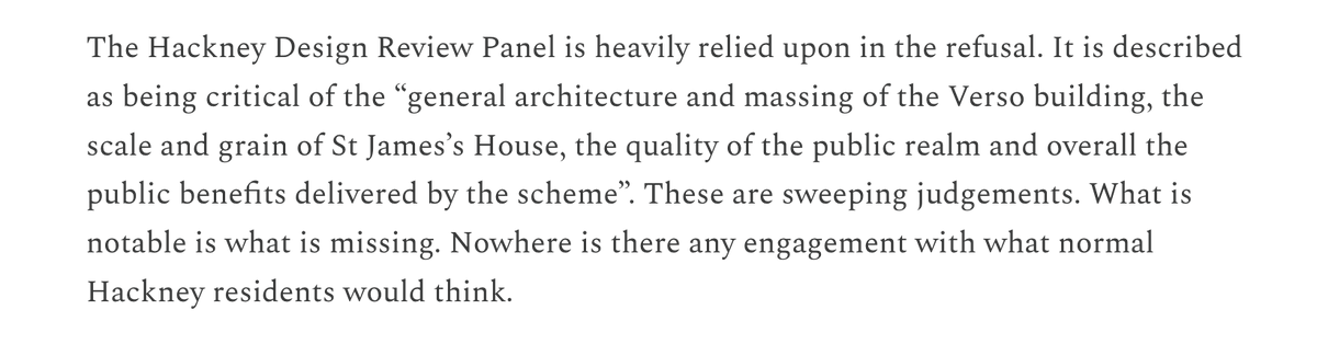
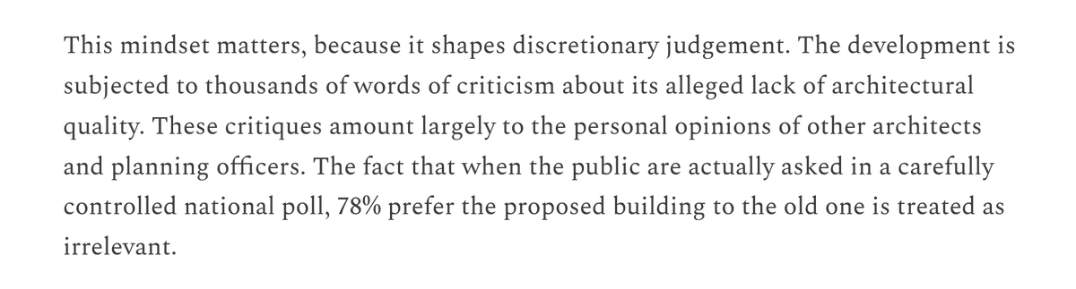
@Michael_J_Hil The Design Review Panel's disapproval is given much weight, while demonstrable public approval is not considered at all.
I know developers don't make the most convincing 'sob story' protagonists, but I do feel rather sorry for them, subject to this suite of bizarre, unreachable and mutually contradictory standards.
But you don't have to care about developers – you just need to care about growth, urbanism or climate, or about Hackney, or about London. I hope the councillors see reason in their meeting this evening.
Nineteenth-century cities grew fast. Berlin’s population grew twenty times, Manchester’s twenty-five times, and New York’s a hundred times. Sydney’s population grew around 240 times and Toronto’s maybe 1,700 times. Between 1833 and 1900, Chicago’s population grew around five thousand times, meaning that on average it doubled every five years.
Homes were larger and far more affordable. Vast networks of trams, buses and suburban railways were built. Running water, gas, drains and electricity was retrofitted into old fabric. Despite having been built at breakneck speed, cities in 1914 were pretty good places.
How was this achieved? The short answer: vigorous interventionism about streets and drains, state-mandated monopolies for transport and utilities infrastructure, and lightly regulated permissiveness for everything else.
Both admirers and detractors of nineteenth-century urbanism often characterise it as laissez-faire. This is misleading: municipal governments were vigorously interventionist in certain domains.
In Germany, Spain, Italy and the United States, the government normally planned out the future street network of the city, banning landowners from developing their land except in line with the official ‘extension plan’.
This is the origin of the famous American grid plans, as well as the characteristic boulevard urbanism of many continental cities.
Here are the plans for New York, Madrid, Berlin and Milan.
In Britain and France, the state did not plan street networks in such a wholesale way, but it was still heavily involved. It often mandated key roads, including driving them through historic urban fabric. It also set minimum road widths and generally banned cul-de-sacs.
Victorian cities were extremely generous in how much space they reserved for public streets. Central New York has 36 percent road share against 30 percent in London and 29 percent in Paris. This is in line with UN recommendations today (30 percent) and far higher than most cities in emerging economies (~15 percent).
The Government has announced where it wants to build its twelve new towns. Here is my review.
Short version: they've done quite a good job.
The key context is that England’s housing shortage is heavily concentrated in certain areas, as shown by Anna Powell-Smith's map of floorspace values below. We should generally focus housebuilding in these areas, because:
1. Doing so has far more effect on alleviating housing scarcity than building in places without shortages;
2. Because housing scarcity is normally driven by people’s desire to move towards employment centres, it has more economic impact;
3. Receipts from house sales are much higher; this means that the government can capture some of them through development levies and use it to fund superb infrastructure.
The importance of this is evident from England’s new town history. The early postwar new towns built near London were mostly economically successful, whatever we may think of their urban design. The later ones, displaced by NIMBYism to more deprived areas, have often struggled. (The fluke exception of Milton Keynes.)
Worse still, the Mark II New Towns tended to undermine existing city centres by drawing limited demand away from urban renewal.
Over the last three years, housebuilding in London has collapsed. Molior recorded just 2,158 private starts in the first half of 2025, around 5% of London’s (low) targets, and still falling.
What is going on? I have posed this question to numerous specialists, most of whom cannot comment publicly for professional reasons. This thread is a summary of what I have gleaned.
The headline reason for the collapse of housebuilding is the establishment of a quango called the Building Safety Regulator, whose approval has been required since April 2024 (after a transitional period starting in 2023) for all tall buildings.
The BSR immediately became heavily backlogged, so many projects that would have started over the last year are stuck in the enormous queue of applications waiting for the BSR’s attention. Because a far higher share of new builds are apartments in tall buildings in London than elsewhere, this disproportionately affects London.
I originally thought this was the main cause of the current crisis, which made me relatively relaxed about it, since after all the Government can solve the backlog by simply increasing the BSR’s capacity. (It has indeed since done this.)
Unfortunately, things aren’t so simple.
One problem is that the BSR not only approves applications slowly – it generally doesn’t approve them at all. In fact, the BSR rejects about 70% of applications. This is a staggering figure. The British planning system (itself not always a model of predictability!) rejects just 11% of applications, and even fewer on large sites.
Rejections cause delays, which are wildly expensive for developers, so they expend enormous resources on getting their applications right. If 70% of them are still getting rejected, it suggests developers *don’t know* how to meet the BSR’s standards, or *simply can’t* do so.
This is a regulatory system in full crisis. The Government urgently needs to look at the standards it has set and the body that is implementing them to work out what is going wrong.
Most of Inner London fell into poverty in the twentieth century, and expensive neighbourhoods like Notting Hill, Pimlico and Islington were seen as slums just decades ago. Here is a street in Notting Hill in the 1970s and today.
Why did this happen? Some thoughts.
First, let's remember when this happened. The decline starts around 1920. Population continues to fall until about 1990, although gentrification had already started in the 1970s and 80s. Since then, the population has risen steadily.
In lots of older literature, the decline is attributed to suburbanisation enabled by mechanised transport. That might have been plausible in 1990. But it isn't plausible at all today: we still have mechanised transport, and yet floorspace in Inner London is way *more* valuable than it is in suburban areas, as this price map by @yimbyalliance shows.
Japan is famed for its flourishing urban life, with peerless infrastructure and vibrant urban density. The bewildering image below is Tokyo's rail map, the world's most extensive network, and one of the true wonders of the world.
But it was not always so. Japan entered the twentieth century with large but impoverished cities, whose infrastructure was exceptionally poor. Most of these were then destroyed by war.
Japan developed perhaps the best cities of the modern world in spite of some of the worst starting conditions. An important part of the explanation lies in a policy called ‘land readjustment’.
Tokugawa cities obviously did not have trains, trams, buses or cars. More surprisingly, they made little use of wheeled transport, relying on pack animals, canals and porters. This meant they only needed narrow and crooked roads.
The Shogunate divided up commoner areas with walls and gates to monitor and control the movement of the population. They often discouraged the building of bridges for the same reason.
The whole structure of Tokugawa cities was thus antithetical to modern transport needs.
Additionally, after the Second World War, the American occupying authorities redistributed Japanese rural land into very small plots, often just one hectare each. This hampered urban expansion, since the smallholders struggled to coordinate to provide infrastructure.
In the nineteenth century, railways were the dominant form of mechanised transport. Vast networks were built in many countries. In 1846, the British Parliament mandated 9,500 miles of railways, of which two thirds were ultimately built. By contrast, HS2 will be 140 miles.
This was an epoch-defining achievement. But when they reached existing cities, the Victorians faced a key constraint: they did not have the technology to bore tunnels deep under cities, and it was fantastically contentious and expensive to plough through them.
This meant that C19 railways tended to terminate on the urban periphery, ultimately forming a network that resembled a ‘wheel without a hub’. Today, cities have expanded far beyond that urban periphery, but the old suburban railways still fail to join together in the middle.