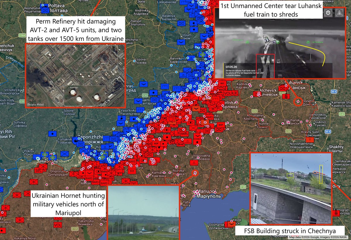
Daily Ukraine map thread for Wednesday 29th April 2026
Highlights: Today we zoom out, to look at a handful of the strikes done this month (April) alone. In one of the longest successful strikes thus far, Perm pumping station was hit by a strike causing two large storage tanks to burn heavily. A Lyuity type drone also reached Orsk refinery near the Kazakhstan border.
In a rare interesting midstrike, a forward operating base for Russian army aviation was struck, destroying an Mi-17 and Mi-28.
On the front, the flanks at Kostyantynivka are under severe pressure. The entire Kostyantynivka to west of Siversk area is under severe threat.
Elsewhere, we've pulled Russian presence back. The Dniper islands, which we hadn't touched for quite some time, as one example.

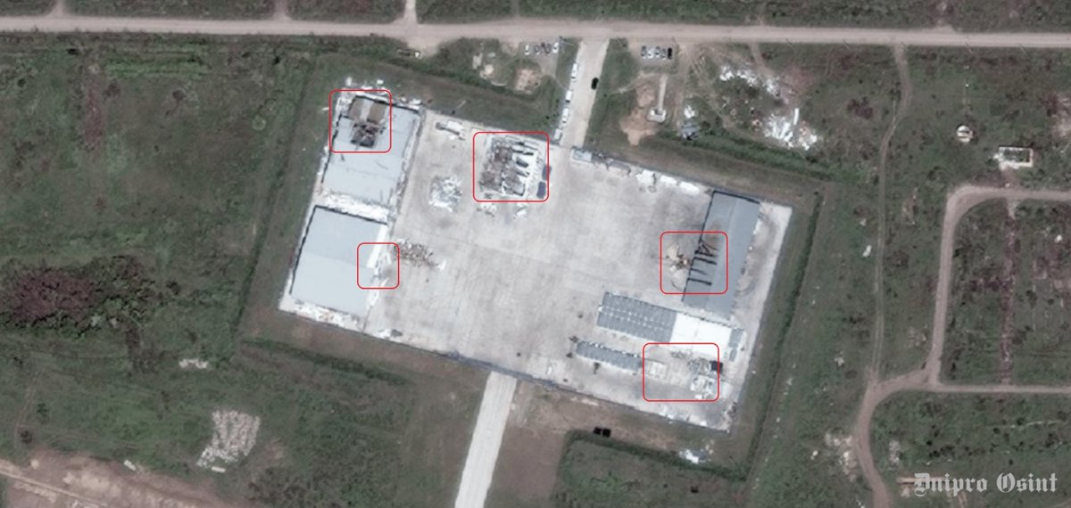
2/ High res of destruction at Orion UAV hangars in Kirovske airfield, Crimea
Coordinates: 45.173470,35.176723
Source: @GarbuzYe
Coordinates: 45.173470,35.176723
Source: @GarbuzYe
https://x.com/Zeldamices/status/2049229922233675853
3/ Batallón PASKUDA, Kraken 1654 hits Russian towed artillery in treeline west of Holykove, Luhansk
Coordinates: 49.141205, 37.851184
Source:
Coordinates: 49.141205, 37.851184
Source:
https://x.com/Kukulkan415/status/2049175505534853471
4/ Rarog hits 2 motorcycles at once, one during a front-flip, showing the dangers of riding motorbikes on terrible roads west of Bakhmut
Coordinates: 48.572628, 37.948029
Source:
Coordinates: 48.572628, 37.948029
Source:
https://x.com/klinger66/status/2049192205458219085
5/ RU 165th Artillery Brigade hits claimed Ukrainian 2S3 Akatsia using Lancet. W of Chervona Krynytsia, Zaporizhia.
Coordinates: 47.608682, 35.872702
Source:
Coordinates: 47.608682, 35.872702
Source:
https://x.com/juss_men/status/2049206915582861689
6/ Russian forces struck Ukrainian communications equipment on one of the islands southwest of Kherson, Kherson oblast.
Coordinates: 46.561875, 32.488260
Source:
Coordinates: 46.561875, 32.488260
Source:
https://x.com/RoadtoMars9/status/2049224450143576451
7/ Massive smoke cloud from Tuapse Refinery seen from Krasnaya Polyana ski resort , 105 km away POV
Coordinates: 43.641174, 40.261858
Source:
Coordinates: 43.641174, 40.261858
Source:
https://x.com/neonhandrail/status/2049234186272477235
8/ 95th Air Assault Brigade strike Russian Ladas, trucks, bukhankas in the Velyka Novosilka direction
Coordinates: 47.828296, 36.698758
Source:
Coordinates: 47.828296, 36.698758
Source:
https://x.com/moklasen/status/2049250363522380019
9/ Two Russian casualties in Staryi after Hart brigade strikes
Coordinates: 50.392804, 37.475077
Source:
Coordinates: 50.392804, 37.475077
Source:
https://x.com/jimmhelloman555/status/2049302102736847032
10/ Russian forces from the 90th Guards Tank Division shelled Ukrainian positions in a treeline northwest of Filiya, Dnipropetrovsk oblast.
Coordinates: 48.099922, 36.722612
Source:
Coordinates: 48.099922, 36.722612
Source:
https://x.com/RoadtoMars9/status/2049347142582718473
11/ Ukrainian position in Illinivka hits by Drone Drop
Coordinates: 48.490927, 37.664299
Source:
Coordinates: 48.490927, 37.664299
Source:
https://x.com/AudaxonX/status/2049371506942091611
12/ Ukrainian drone attack in Orsk, towards the refinery POV
Coordinates: 51.223858, 58.507322
Source:
Coordinates: 51.223858, 58.507322
Source:
https://x.com/neonhandrail/status/2049385907938263366
13/ 39th Anti-Aircraft Missile Regiment Poksypaki intercepts Zala KUB RU near Veselyanka - Zaporizhzhia
Coordinates: 47.672430, 35.404253
Source:
Coordinates: 47.672430, 35.404253
Source:
https://x.com/MikiValbuena/status/2049381361136374177
14/ Russian T-55A hit by drone in Yablukove, Zaporizhia
Coordinates: 47.712660, 36.316020
Source: t.me/lost_warinua/1…
Coordinates: 47.712660, 36.316020
Source: t.me/lost_warinua/1…
15/ UAV 'Pentagon' of 225th Assault Regiment hits Russian Ural in Hulyaipole
Coordinates: 47.651007, 36.288488
Source:
Coordinates: 47.651007, 36.288488
Source:
https://x.com/MikiValbuena/status/2049408485083730185
16/ PoV of Russian column of 18 Kamaz towing old Zis-3 and other outdated guns near Moscow
Coordinates: 55.494725, 37.030768
Source:
Coordinates: 55.494725, 37.030768
Source:
https://x.com/MikiValbuena/status/2049463315538076149
17/ Reported positions of the Russian special unit BARS-Sarmat attacked with drones by the 413th UAS regiment 'Reid' in Kyrylivka, Zaporizhia.
Coordinates: 46.411180, 35.414640
Source:
Coordinates: 46.411180, 35.414640
Source:
https://x.com/blinzka/status/2049465018438029729
18/ Attack on the reported reserve concentration of the Russian 36th motorized rifle brigade by the 1st unmanned systems center.
Coordinates: 47.850727, 36.824183
Source:
Coordinates: 47.850727, 36.824183
Source:
https://x.com/blinzka/status/2049472845684568507
19/ Russian Nebo-M radar destroyed by 429th Achilles RAM-2 drone
Coordinates: 51.201300, 37.095050
Source:
Coordinates: 51.201300, 37.095050
Source:
https://x.com/klinger66/status/2049487275768049839
20/ Storage tank at Perm pump station burning after drone strike
Coordinates: 57.798690, 55.886210
Source: x.com/HpwWJVafCv8395… and x.com/tom_bike/statu…
Coordinates: 57.798690, 55.886210
Source: x.com/HpwWJVafCv8395… and x.com/tom_bike/statu…
21/ Comms building (?) hit in crimea by 1st Unmanned Center
Coordinates: 44.485880, 34.026960
Source:
Coordinates: 44.485880, 34.026960
Source:
https://x.com/carse_n/status/2049518542639305200
22/ UA 33rd Mech hit RU west of Tabaivka.
Coordinates: 49.605557, 37.805141
Source:
Coordinates: 49.605557, 37.805141
Source:
https://x.com/richardzai38580/status/2049529256212922806
23/ RU 25th CAA attacks UA position in a treeline with Molniya-2 drone near Zarichne, Donetsk
Coordinates: 49.061176, 37.865742
Source:
Coordinates: 49.061176, 37.865742
Source:
https://x.com/ZoamSc2/status/2049541987087585298
24/ A Russian Tor-M2 air defense system was destroyed by Ukrainian 1st Unmanned Center drone in Tykhonivka, Zaporizhia Oblast, Ukraine
Coordinates: 46.911430, 35.521417
Source:
Coordinates: 46.911430, 35.521417
Source:
https://x.com/99Dominik_/status/2049499130553041334
25/ Ukranian drones struck two Russian Mi-28 and Mi-17 helicopters near the village of Babki in the Voronezh region. 152 km from the border Coordinates: 50.2374735247992, 39.74832327314057
Coordinates: 50.237474, 39.748323
Source:
Coordinates: 50.237474, 39.748323
Source:
https://x.com/GarbuzYe/status/2049506216951292390
• • •
Missing some Tweet in this thread? You can try to
force a refresh