Daily Ukraine map thread for Friday 8th May 2026
An early one today, showcasing just some of the mid and long range strikes of the past couple of days.
Other long range strikes not included include the Karakurt class Tucha hit in the Caspian sea, more strikes on warehouses and logistics, Rostov being and Yaroslavl refinery burning again. There are many other strikes, also included on the map which you can find via the link in our profile. Many thanks to the geolocators here.
Very little change on the front, still heavy infantry pressure on the front, but the distinct lack of vehicles means Russia can't really capitalise on any of it and they just end up out of position and eliminated. Those new plinths at the memorials aren't going to fill themselves.
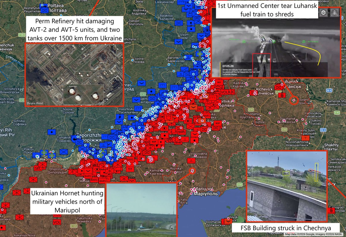
2/ A train with fuel tankers is hit with drones by the 1st unmanned systems center of Ukraine near Novosimeikyne, Luhansk.
Coordinates: 48.346346, 39.613890
Source:
Coordinates: 48.346346, 39.613890
Source:
https://x.com/blinzka/status/2052525102239973482
3/ 4th Guard Battalion, 101st Security Brigade Of The General Staff observes a Russian-held trench south-west of Stepanivka hit 1:08-1:12
Coordinates: 48.43799, 37.58817
Source:
Coordinates: 48.43799, 37.58817
Source:
https://x.com/AudaxonX/status/2052456280917164254
4/ Ukrainian hornet flying ultra low hunting for targets on the Mariupol highway at 100km depth
Coordinates: 47.37056, 37.53973
Source:
Coordinates: 47.37056, 37.53973
Source:
https://x.com/moklasen/status/2052469050060505535
5/ Location: Veterynarne (Ветеринарне), Kharkiv Oblast, Ukraine, 0:13 at A Russian soldier waves a flag and the buildings are heavily damaged with drones by the 58th brigade of Ukraine afterwards.
Coordinates: 50.39041, 36.18767
Source:
Coordinates: 50.39041, 36.18767
Source:
https://x.com/blinzka/status/2052471744946917599
6/ RU tank of the "Central" military grouping hit by UA "Perun" UAV battalion of the 42nd SMBr in Zelenyy Kut, Donetsk oblast.
Coordinates: 48.020730, 36.901320
Source:
Coordinates: 48.020730, 36.901320
Source:
https://x.com/ukrliberation/status/2052495025926205456
7/ A Russian drone operator position is hit by the 50th artillery brigade of Ukraine in Kurkovichi, Kursk.
Coordinates: 52.286842, 32.813110
Source:
Coordinates: 52.286842, 32.813110
Source:
https://x.com/blinzka/status/2052484302508589128
8/ PoV of fire burning at Yaroslavl refinery
Coordinates: 57.545722, 39.800257
Source:
Coordinates: 57.545722, 39.800257
Source:
https://x.com/NotWoofers/status/2052523228577329456
9/ FP-2 strikes on Russian warehouse buildings in Smolyanynove
Coordinates: 48.951154, 38.709670
Source:
Coordinates: 48.951154, 38.709670
Source:
https://x.com/AndrewPerpetua/status/2052455769992200590
10/ Ukrainian Prymary unit drone strike on the roof of a building manned with soldiers, claimed as electronic warfare laboratory, in Novoozerne.
Coordinates: 45.387177, 33.112582
Source:
Coordinates: 45.387177, 33.112582
Source:
https://x.com/blinzka/status/2052545033136431314
11/ RU 164th Motorized Rifle Brigade Drone Unit "Horde" attacks UA positions with FPV drones near Dibrova
Coordinates: 48.930410, 37.858070
Source:
Coordinates: 48.930410, 37.858070
Source:
https://x.com/ZoamSc2/status/2052572895440945489
12/ The Ukrainian military struck the research and production branch of the “Radar” Scientific and Technical Center in Rostov
Coordinates: 47.256288, 39.596866
Source:
Coordinates: 47.256288, 39.596866
Source:
https://x.com/GarbuzYe/status/2052631385504944252
13/ 71st Motor Rifle Regiment intercepts drone near Preobrazhenka - Zaporizhzhia Ob
Coordinates: 47.568211, 35.818601
Source:
Coordinates: 47.568211, 35.818601
Source:
https://x.com/MikiValbuena/status/2052644045420163184
14/ 7th Military Base hits a Ukrainian handcart in Oleksijevo-Druzhkivka with a Fibre Optic FPV Drone
Coordinates: 48.567177, 37.620282
Source:
Coordinates: 48.567177, 37.620282
Source:
https://x.com/AudaxonX/status/2052659867840581932
15/ UAV 'Valkiria' of 4th Military Base captures Ukrainian Mavic near Stepove
Coordinates: 47.542491, 35.483381
Source:
Coordinates: 47.542491, 35.483381
Source:
https://x.com/MikiValbuena/status/2052666850190770447
16/ A Ukrainian drone hit FSB building in Znamenskoe, Chechnya
Coordinates: 43.672675, 45.110477
Source:
Coordinates: 43.672675, 45.110477
Source:
https://x.com/99Dominik_/status/2052681985630302534
17/ 100th Mechanized Brigade in Kostyantynivka hits RU soldiers in a pipe with a FPV Drone
Coordinates: 48.487448, 37.703734
Source:
Coordinates: 48.487448, 37.703734
Source:
https://x.com/AudaxonX/status/2052704150098481463
18/ The Ukrainian Armed Forces attacked the Yaroslavl Oil Refinery again overnight. At least the AVT-3 unit was hit, and a fire broke out at the site
Coordinates: 57.545924, 39.800109
Source:
Coordinates: 57.545924, 39.800109
Source:
https://x.com/GarbuzYe/status/2052701352808030404
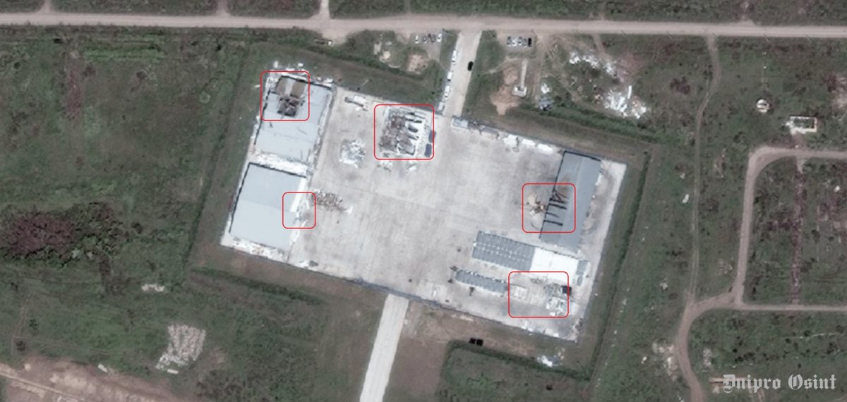
19/ Satellite images also show the aftermath of yesterday’s attack. Two storage tanks and the AVT-2 unit were damaged. In total, the two attacks have disabled 30–50% of the plant’s primary oil refining capacity.
Coordinates: 57.913396, 56.127690
Source:
Coordinates: 57.913396, 56.127690
Source:
https://x.com/GarbuzYe/status/2052715562845774025
20/ Satellite images showing the aftermath of this morning’s strike on the Lukoil-Permnefteorgsintez oil refinery in Perm A fire has been reported at the AVT-5 unit
Coordinates: 57.908640, 56.122718
Source:
Coordinates: 57.908640, 56.122718
Source:
https://x.com/GarbuzYe/status/2052707057451548708
• • •
Missing some Tweet in this thread? You can try to
force a refresh