Stinky Profile picture
May 22 10 tweets 5 min read Read on X
🧵Google Earth has updated its satellite imagery to 2026 for the central and south Gaza strip.

In this thread, we will be going over some areas that I found interesting while I explored the update.

If you want a screenshot of a site, reply with the coordinates, and ill send. Image
Before we begin, it is necessary to note that, as this update only occurred today, it is only available on the Google Earth "Pro" application, available on PC/Laptop, not on the web version.

More info on how to download Google Earth Pro:


Now let's begin!
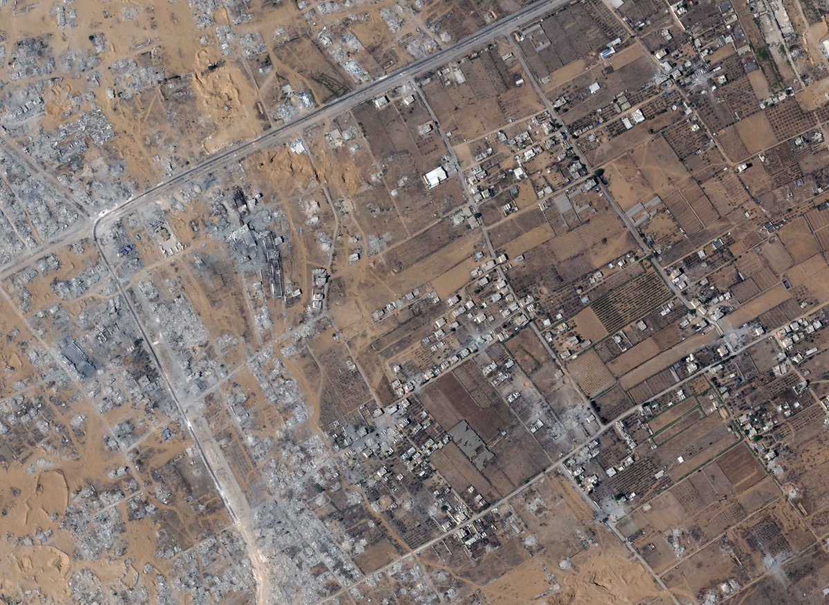
Zoomed out image of Rafah City and the wider Rafah Governorate, dated February 24, 2026. Image
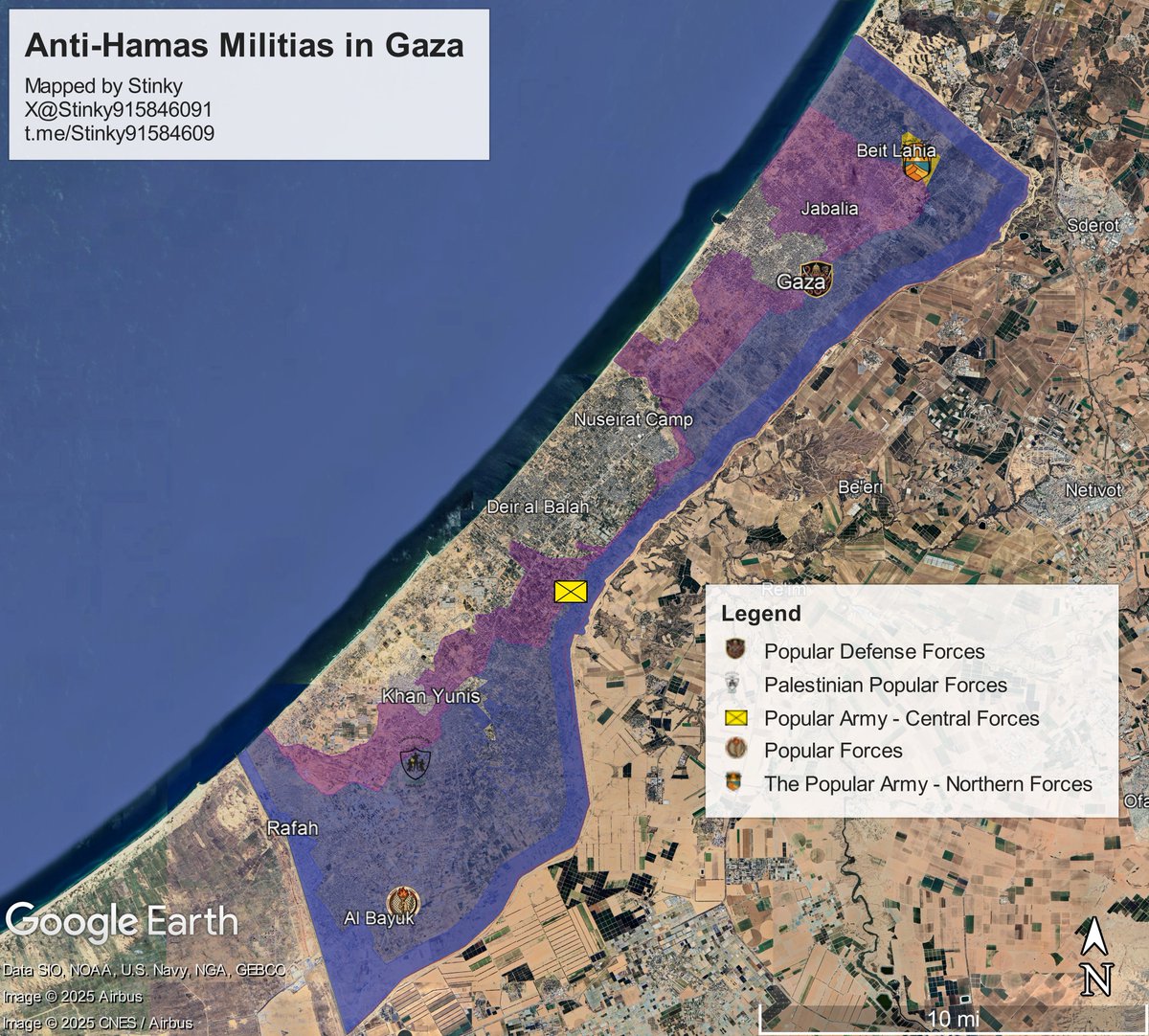
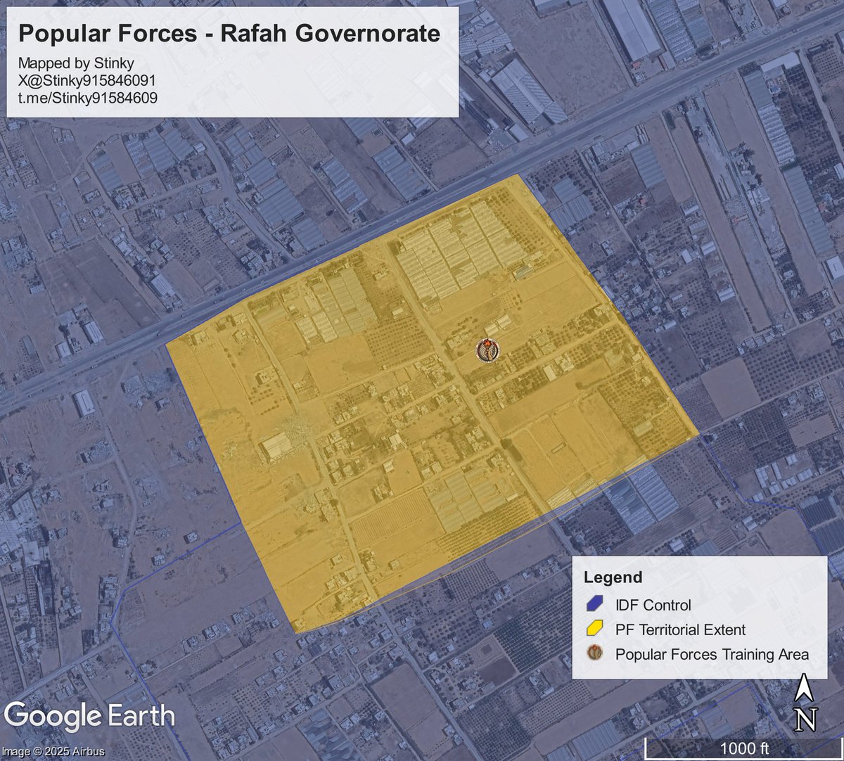
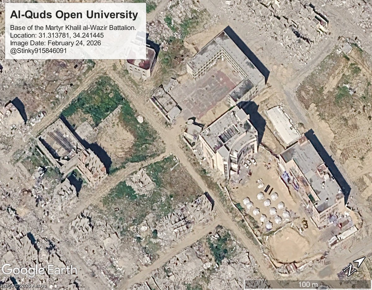
Photographs of the bases of 4 Anti-Hamas militias, them being the Popular Forces, Counter-Terror Strike Force, Free Homeland Forces, and the Martyr Khalil al-Wazir Battalion.

More Info on the militias from this thread, which covered each group: Image
Image
Image
Image
Cleared/demolished zone in the Al Hashash area of Rafah, this was reportedly where "Green Rafah" was supposed to be set up, however work at the site has stopped since the joint U.S.-Israeli air campaign against Iran started.

More Info on the clearing:
Image
Regavim Checkpoint, on the intersection of the Morag Corridor and the Salah Al Din Road, which Gazans needed to pass through before arriving at Rafah Crossing.

More information on Regavin Checkpoint: Image
Tent Camps in the Khan Yunis / Al-Mawasi area. Image
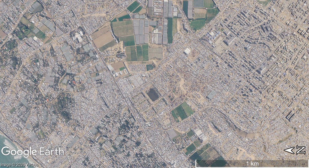
Heavy destruction in Bani Suheila and eastarn Khan Yunis. The road which forms the "Magen Oz" corridor is visible.

Image
Still standing buildings at the Al Idari area of Rafah City, or the intersection of Al Halaby and Almaslakh Sreet. Image
The European Hospital Complex, the site where Mohammed Sinwar (commander of Hamas' Qassam Brigades) was assassinated.

If you look closely, you could see the dug up area behind the line of trees.

Image

• • •

Missing some Tweet in this thread? You can try to force a refresh
 

Keep Current with Stinky

Stinky Profile picture

Stay in touch and get notified when new unrolls are available from this author!

Read all threads

This Thread may be Removed Anytime!

PDF

Twitter may remove this content at anytime! Save it as PDF for later use!

Try unrolling a thread yourself!

how to unroll video
  1. Follow @ThreadReaderApp to mention us!

  2. From a Twitter thread mention us with a keyword "unroll"
@threadreaderapp unroll

Practice here first or read more on our help page!

More from @Stinky915846091

May 11
🧵Who are the anti-Hamas militias in Gaza?

In recent weeks, these groups expanded beyond their usual areas, clashing with Hamas, entering new zones, and interacting openly with locals.

This thread aims to explain who they are, where they operate, and who leads them. Image
Popular Army - Northern Forces.

Established in September of 2025, by Ashraf al-Mansi. It is Headquartered at the Izbat Beit Hanoun Elementary School for Boys, on Al Awda Street.

Location: 31.547334, 34.518417
8G3PGGW9+W9 North Gaza Governorate, Gaza Logo of the Popular Army - Northern Forces
Ashraf al Mansi
Satellite photo of the Izbat Beit Hanoun Elemntary School for boys, courtesy of @GEOIMINT
Since April, videos posted by the Northern Army, with some being geolocated by @Arabosint show them operating beyond the yellow line in Atatra/Beit Lahia, mingling with locals, while distributing material/financial aid to them.

More Info:
Image
Read 18 tweets
Apr 25
🧵Lebanon Update 4.24.26

Summary:
- IDF Raids Dibbine / North Marjaayoun
- Demolition Activity in Houla and Bint Jibel
- IDF Enters At Tiri
- Clearing Activity along the coast

Map Link: google.com/maps/d/u/0/emb…
H/T: @LebMonitor1
Satellite Imagery: @SoarAtlas

More Info Below⏬ x.com/Stinky91584609…Image
Sentinel-2 images confirm that the IDF conducted a raid on the village of Dibbine just before the ceasefire.

It is highly likely that they withdrew from the area now that the ceasefire came into effect, however it is still unclear. Image
The IDF entered At-Tayri for the first time, with demolition activity visible on S2.

Looking east, a large expansion of demolition ops is clear in in the city of Bint Jibel, a former Hezbollah Stronghold.

Other clearing activity spotted in Hanine/Rchaf. Image
Read 7 tweets
Mar 18
🧵Lebanon Update 3.17.26 (H/T: @LebMonitor1)
S2: @SoarAtlas

Summary:
- IDF re-enters Yaroun+Maroun El Ras
- IDF enters Taybeh
- Heavy demolition activity in Ayta al Shab and Rab El Thalathine
- IDF Controls most of Khiam

Map Link:

More info below ⏬ google.com/maps/d/u/1/emb…Image
Since the last update, the IDF has taken control of most of Khiam, and Sentinel-2 imagery from @Soaratlas shows demolition activities in the eastern portions of the town. Image
The IDF has expanded its area of control heavily, taking control of Rab El Thalatine, Kfarkela, and Markaba.

Sentinel-2 📸 indicate they enter Taybeh for the first time.

A previous geolocation shows they were also active in the area near Houla.
Geo: Image
Read 6 tweets
Jan 10
🧵Google has released a big update updating its satellite photos to 2025 in large portions of Lebanon and Southern Syria.

In this thread we will be looking at sites I found interesting while I explored this new update. Image
Disclaimer: this update as of posting, is only available on the Google Earth "Pro" app, not the web version that you can get on your browser/phone.

To explore on the Pro version, see , scroll down, and click Download Earth Pro on Desktop.

Now let's begin! google.com/earth/about/ve…Image
Image
Border villages following the Israel-Hezbollah war from 2024.

Location: 33.106957, 35.238338
Image Date: June 5, 2025. Image
Read 12 tweets
Dec 6, 2025
🧵Who are the current Anti-Hamas militias operating inside the Gaza strip?

This is an updated version of a similar thread written by @Arabosint a few months ago, after new developments.

So far, there are 5 militias, spread out throughout each governorate of the Gaza Strip. Image
Popular Forces

It was the first Major Anti-Hamas militia to appear, established during the IDF's Rafah Offensive, and is based in Al Bayuk, southern Rafah. (31.268407, 34.291348)

It has also conducted light operations in the southern Deir Al Balah area.

Image
Image
Image
Until a few days ago, it was headed by Yasser Abu Shabab, who founded the group.

He was killed in a gun fight following an internal dispute.

He was succeeded by his deputy, Ghassan Duhine

See links for more info:
1. x.com/ariel_oseran/s…
2. x.com/Philipp2796084… Image
Read 10 tweets
Oct 28, 2025
The following thread will be publicizing Gaza militants who were killed in the war. The process of identification will mainly be derived from the guide written by @MiddleEastBuka on combatant identification.

My focus will be primarily those on the GHM list available on Airwars. Image
Note that not all details will be 100% accurate. Any additions to the circumstances of a militant's death will be appreciated.

For those interested in researching how to identify these types of individuals, have a look at the quoted thread:
October 18, 2023, Jabalia

Abd al-Ftah Sameir Abd al-Ftah al-Tananei
عبد الفتاح سمير عبد الفتاح الطناني
🆔MoH ID: 400124202
⚠️Popular Front for the Liberation of Palestine [PFLP] (Abu Ali Mustafa Brigades)

Notes: 7/10 Participant

Source: t.me/abualiajel/680Image
Image
Read 46 tweets

Did Thread Reader help you today?

Support us! We are indie developers!


This site is made by just two indie developers on a laptop doing marketing, support and development! Read more about the story.

Become a Premium Member ($3/month or $30/year) and get exclusive features!

Become Premium

Don't want to be a Premium member but still want to support us?

Make a small donation by buying us coffee ($5) or help with server cost ($10)

Donate via Paypal

Or Donate anonymously using crypto!

Ethereum

0xfe58350B80634f60Fa6Dc149a72b4DFbc17D341E copy

Bitcoin

3ATGMxNzCUFzxpMCHL5sWSt4DVtS8UqXpi copy

Thank you for your support!

Follow Us!

:(