Daily Ukraine map thread for Sunday 14th June 2026
After yesterdays footage, Russian sources released further videos showing Ukrainian forces advancing and clearing positions across an area of roughly 200 km² in the western Donetsk / eastern Dnipropetrovsk direction.
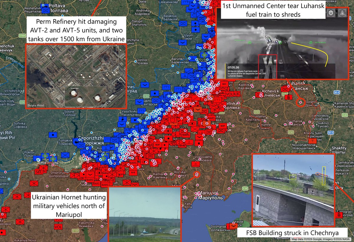
Mid strikes are continuing to rip and tear across the occupied territories, with videos coming out constantly. Long range strikes show no sign of abating either, as Ukraine hit the reserve oil storage in Rybinsk - that's 250 km north east of Moscow.
After yesterdays footage, Russian sources released further videos showing Ukrainian forces advancing and clearing positions across an area of roughly 200 km² in the western Donetsk / eastern Dnipropetrovsk direction.
Mid strikes are continuing to rip and tear across the occupied territories, with videos coming out constantly. Long range strikes show no sign of abating either, as Ukraine hit the reserve oil storage in Rybinsk - that's 250 km north east of Moscow.

2/ Compilation of the RU 1472nd Regiment (68th Army Corps) trying to stop Ukrainian advances in West Donetsk.
Coordinates: 47.86657, 36.57241
Source:
Coordinates: 47.86657, 36.57241
Source:
https://x.com/moklasen/status/2066093709360247128
3/ Damage to buildings in Malokostyantynivka, Luhansk, after a Ukrainian drone attack.
Coordinates: 48.44888, 38.91046
Source:
Coordinates: 48.44888, 38.91046
Source:
https://x.com/99Dominik_/status/2066084295484076482
4/ The Unmanned Systems Battalion "Huntsmen" of the 71st Brigade Attack on a Russian soldier near Novomykolaivka, Sumy
Coordinates: 51.15650, 34.90092
Source:
Coordinates: 51.15650, 34.90092
Source:
https://x.com/Kukulkan415/status/2066106185682456755
5/ Magyars Wormbusters cutting RU logistics in Zaporizhia. Many wrecks - just look at the state of it
Coordinates: 47.81521, 36.58101
Source:
Coordinates: 47.81521, 36.58101
Source:
https://x.com/moklasen/status/2066111323205681277
6/ Russian 238th Artillery Brigade shelling Illinivka
Coordinates: 48.50170, 37.66243
Source:
Coordinates: 48.50170, 37.66243
Source:
https://x.com/franfran2424/status/2066119695246250247
7/ LMUR strike on claimed 77th Airmobile position near Senkove
Coordinates: 49.52276, 37.65099
Source:
Coordinates: 49.52276, 37.65099
Source:
https://x.com/johnspectator/status/2066119864104738925
8/ A Russian tanker truck was hit by Ukrainian B-2 drone. Zhukova Balka, Donetsk Oblast, Ukraine
Coordinates: 47.80359, 38.41684
Source:
Coordinates: 47.80359, 38.41684
Source:
https://x.com/99Dominik_/status/2066149281895997618
9/ Sentinel of pontoon bridge next to the road bridge just south of Henichesk. Hint-ichesk.
Coordinates: 46.14776, 34.80705
Source:
Coordinates: 46.14776, 34.80705
Source:
https://x.com/Rb3qzWR5AK5nooA/status/2066154757597855876
10/ Russian Unmanned Systems Battalion "VBS Strizhi" strikes a house in Piddubne with a Molniya-2 drone.
Coordinates: 48.00852, 36.69535
Source:
Coordinates: 48.00852, 36.69535
Source:
https://x.com/hizzo_jay/status/2066158127129461248
11/ In occupied Enerhodar, Ukrainian forces struck the Russian traffic police building, destroying it from the inside.
Coordinates: 47.50283, 34.65408
Source:
Coordinates: 47.50283, 34.65408
Source:
https://x.com/NOELreports/status/2066167438857658460
12/ Russian 1st Tank Army troops raised flag in Zelenyi Hai. They have 'controlled' this settlement since 2025, so you can see the bizarre logic in why they've chosen to do this today...
Coordinates: 49.406702,37.795262
Source:
Coordinates: 49.406702,37.795262
Source:
https://x.com/richardzai38580/status/2066212468968521935
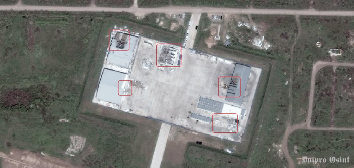
13/ Rybinsk oil storage facility in Yaroslavl struck and burning heavily
Coordinates: 58.02623, 38.94315
Source:
Coordinates: 58.02623, 38.94315
Source:
https://x.com/Zeldamices/status/2066126793623351784
• • •
Missing some Tweet in this thread? You can try to
force a refresh