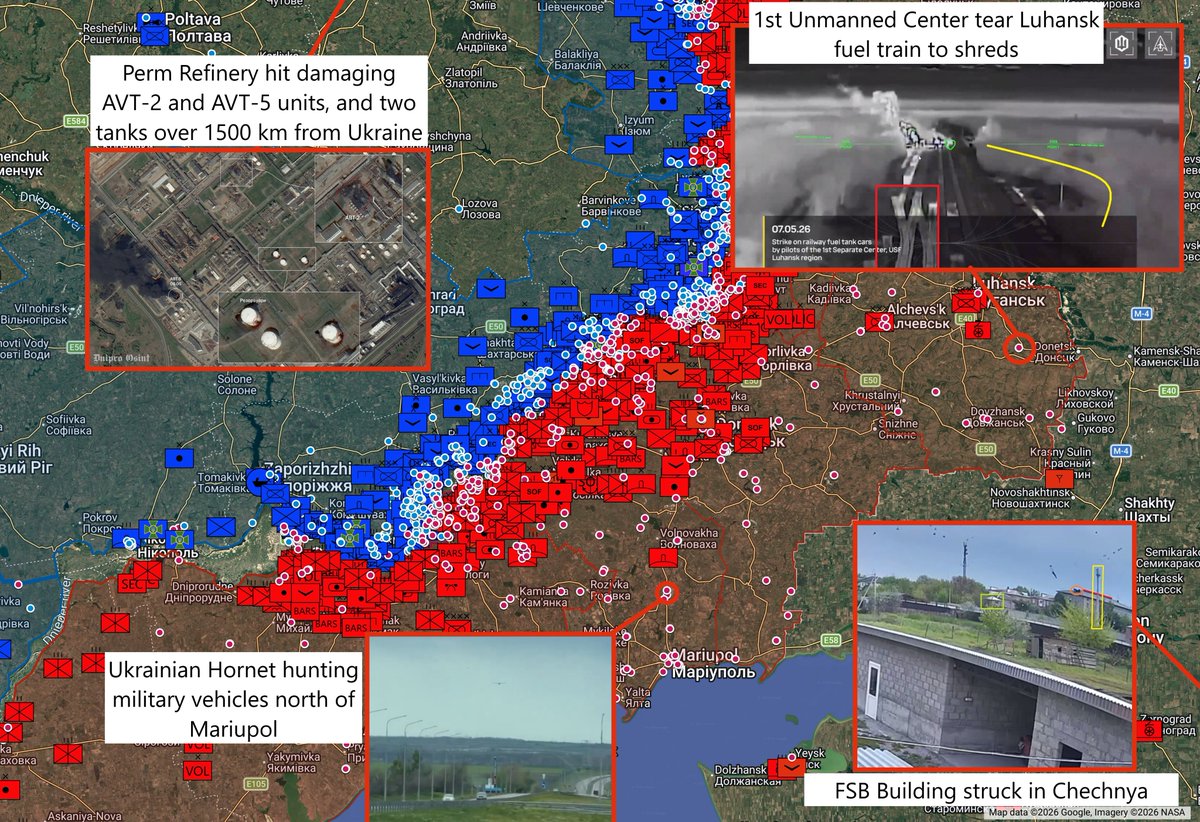
Daily Ukraine map thread for Monday 15th June 2026
Kyiv and other cities were struck by numerous missiles last night. Whilst most of the footage was of attacks on the Lavra, it looks like a Firepoint drone production or assembly facility was hit somewhere judging by some of the photos going around of stacked wing spars in wreckage. As always, loose lips sink ships and all that - if you're hearing it from us, that means it's long gone public ready.
The Ukrainian midstrike and long range campaign continues apace. Numerous units from across the spectrum show destroyed vehicles. The lesser shown off short range drones are still destroying many many vehicles, as demonstrated by a Russian quad driving a short distance towards Hulyaipole coming across at least 17 wrecks.
No BDA from Rybinsk Strategic Oil Reserve yet, but Tamanneftegaz shows three further large oil tanks destroyed. Plenty more to go.

2/ Powerful detonation of Russian vehicle carrying soldiers (and presumed ammo) after FPV drone strike. Siversk, Donetsk Oblast, Ukraine
Coordinates: 48.85346, 38.10250
Source:
Coordinates: 48.85346, 38.10250
Source:
https://x.com/99Dominik_/status/2066558593730503023
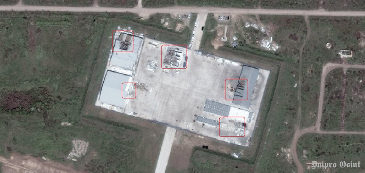
3/ Footage of yesterday’s attack and fire at the Azot JSC site in Novomoskovsk, Tula Region. NAK Azot JSC is one of the largest chemical enterprises in the Russian Federation
Coordinates: 54.22062, 37.61677
Source: x.com/blinzka/status… and x.com/Exilenova_plus…
Coordinates: 54.22062, 37.61677
Source: x.com/blinzka/status… and x.com/Exilenova_plus…
4/ A Russian strike hit a primary school in Kyiv’s Comfort Town residential complex.
Coordinates: 50.43510, 30.62315
Source:
Coordinates: 50.43510, 30.62315
Source:
https://x.com/zarGEOINT/status/2066373888473288945
5/ A fire broke out at the Mystetskyi Arsenal National Art and Culture Museum Complex in Kyiv following a Russian strike.
Coordinates: 50.43367, 30.55455
Source:
Coordinates: 50.43367, 30.55455
Source:
https://x.com/zarGEOINT/status/2066378015374741768
6/ A Russian drone struck a residential building on Hoholivska Street in Kyiv, Ukraine.
Coordinates: 50.45363, 30.49299
Source:
Coordinates: 50.45363, 30.49299
Source:
https://x.com/zarGEOINT/status/2066385248972124355
7/ 103rd Motor Rifle Regiment raised flags in Kostiantynivka.
Coordinates: 48.52175, 37.67500
Source:
Coordinates: 48.52175, 37.67500
Source:
https://x.com/richardzai38580/status/2066389814417698951
8/ Russian Aerospace Forces airstrikes using bombs with UMPK glide kits in Rai-Oleksandrivka
Coordinates: 48.81414, 37.80282
Source:
Coordinates: 48.81414, 37.80282
Source:
https://x.com/hgtvgloober/status/2066393582240408050
9/ A russian nightvision fiber optic FPV drone from the 57th Motor Rifle Brigade of the 5th Army of the 'Vostok' grouping struck a Ukrainian position near Solodke, Zaporizhzhia
Coordinates: 47.78118, 36.27156
Source:
Coordinates: 47.78118, 36.27156
Source:
https://x.com/RoadtoMars9/status/2066401725590765575
10/ The Dnipro Industrial College sustained damage in overnight Russian strikes on the city.
Coordinates: 48.47628, 34.98713
Source:
Coordinates: 48.47628, 34.98713
Source:
https://x.com/zarGEOINT/status/2066407426568380838
11/ A Ukrainian Zozulia drone (422nd Luftwaffe and SBU) hit Russian electronic warfare system that were designed to interfere with Starlink communications in Prymorsk, Zaporizhia
Coordinates: 46.74257, 36.35938
Source: x.com/99Dominik_/sta… and x.com/carse_n/status…
Coordinates: 46.74257, 36.35938
Source: x.com/99Dominik_/sta… and x.com/carse_n/status…
12/ RU 657th Anti Tank battalion and 14th Spetsnaz Brigade and 43rd Spetsnaz Company hit a UA vehicle many times and finally destroyed it in Havrylivka.
Coordinates: 48.08611, 36.52027
Source:
Coordinates: 48.08611, 36.52027
Source:
https://x.com/richardzai38580/status/2066435379247698298
13/ As a result of a Russian attack, four rescuers and one employee of the Kharkiv City Council's Department of Emergency Situations were killed. Another six rescuers were injured.
Coordinates: 50.00889, 36.19837
Source:
Coordinates: 50.00889, 36.19837
Source:
https://x.com/99Dominik_/status/2066441302426685694
14/ UA 43rd Mech hit RU soldier in Kurylivka.
Coordinates: 49.65827, 37.66693
Source:
Coordinates: 49.65827, 37.66693
Source:
https://x.com/richardzai38580/status/2066442634382774670
15/ RU 50th Brigade "Varyag" attacks claimed UA "GUR Kraken" headquarters (claimed*) in Kharkiv
Coordinates: 49.95051, 36.35445
Source:
Coordinates: 49.95051, 36.35445
Source:
https://x.com/ne_kotletka/status/2066454558939754545
16/ Kramatorsk Direction. Burevestnik Separate Regiment of Unmanned Systems targeting UA infantry. (Dobrokor Fakel UAV Unit)
Coordinates: 48.72206, 37.78369
Source:
Coordinates: 48.72206, 37.78369
Source:
https://x.com/franfran2424/status/2066488980728643695
17/ A Russian FPV drone destroyed an ambulance and injured a nurse. Kushuhum, Zaporizhia Oblast, Ukraine
Coordinates: 47.72818, 35.20889
Source:
Coordinates: 47.72818, 35.20889
Source:
https://x.com/99Dominik_/status/2066475627868242111
18/ A fuel truck was destroyed by Ukrainian HURs Bulava drone near Dolynske, Zaporizhia Oblast, Ukraine, detonating violently and the driver when goes on fire as he flees
Coordinates: 46.81825, 35.18307
Source:
Coordinates: 46.81825, 35.18307
Source:
https://x.com/99Dominik_/status/2066511544045695099
19/ A Russian Tu-22M3 bomber crashed in Irkutsk Oblast. Kamenka, Irkutsk Oblast, Russia. Presumed engine failure, such as the previous two crashes in Irkutsk over a year ago
Coordinates: 53.13681, 103.40401
Source:
Coordinates: 53.13681, 103.40401
Source:
https://x.com/99Dominik_/status/2066521025278259223
20/ The Dormition Cathedral of the Kyiv Pechersk Lavra, one of the most sacred places in the Orthodox Christian world, is on fire after Russian strike
Coordinates: 50.43523, 30.55759
Source:
Coordinates: 50.43523, 30.55759
Source:
https://x.com/neonhandrail/status/2066316956035436636
21/ At least 17 destroyed vehicles on supply road towards Hulyaipole, as Russian quad attempts to navigate it
Coordinates: 47.640445, 36.417218
Source:
Coordinates: 47.640445, 36.417218
Source:
https://x.com/moklasen/status/2066589746512728090
• • •
Missing some Tweet in this thread? You can try to
force a refresh