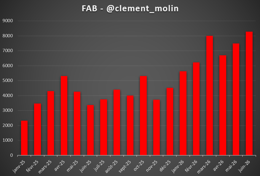
Who controls Kostiantynivka 🇷🇺/🇺🇦 ?
There is a very big debate to know who really controls the city of Kostiantynivka, in the Donbas region.
Many maps are showing the city as Russian controled, which in my opinion is not true, as I will explain it here.
🧵THREAD🧵1/16 ⬇️
There is a very big debate to know who really controls the city of Kostiantynivka, in the Donbas region.
Many maps are showing the city as Russian controled, which in my opinion is not true, as I will explain it here.
🧵THREAD🧵1/16 ⬇️
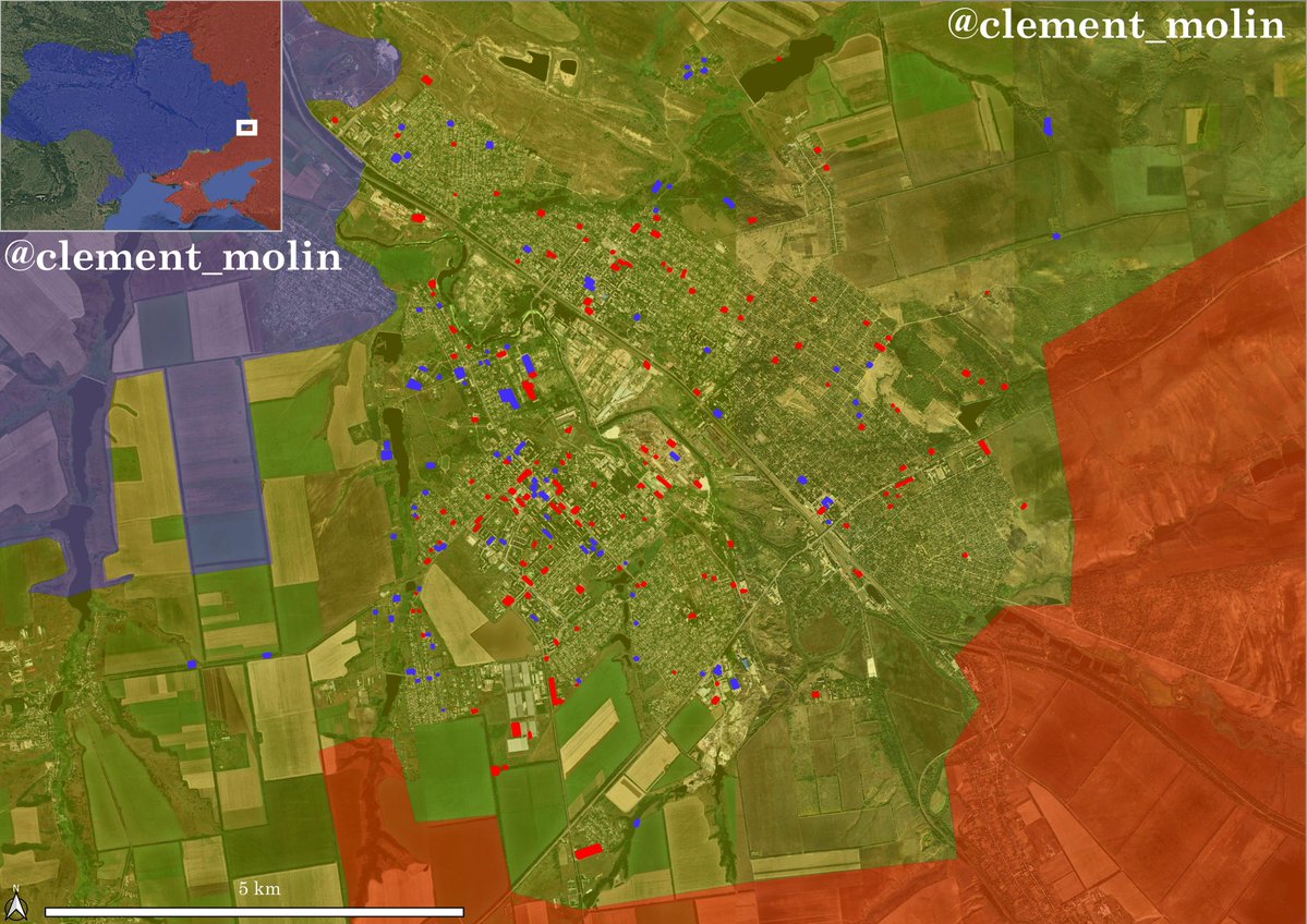
I gathered geolocations for the last 40 days in the city, from @UAControlMap, mainly done by @AudaxonX.
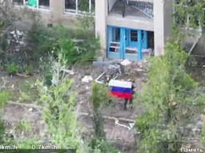
Those geolocations show flag videos, air, artillery and drone strikes as well as assault videos.
3 things you should know :
🔸We only see 5% maximum of the real situation on videos, those are known positions at a given moment, which is nowhere close to the reality on the ground.
🔸There is an important image assymetry. Russia is posting more videos of flags and few strikes while Ukraine doesn't publish flag videos but publish much more strikes. Thus, I have 146 places where Russian are confirmed present, against 94 Ukrainian. This doesn't mean there are more Russians than Ukraine, Russia published 70 videos of flags !
🔸On the map, we have plenty of areas undereported, with few Ukrainian positions when we know there are many or few Russian positions when we know there are many.
Those geolocations show flag videos, air, artillery and drone strikes as well as assault videos.
3 things you should know :
🔸We only see 5% maximum of the real situation on videos, those are known positions at a given moment, which is nowhere close to the reality on the ground.
🔸There is an important image assymetry. Russia is posting more videos of flags and few strikes while Ukraine doesn't publish flag videos but publish much more strikes. Thus, I have 146 places where Russian are confirmed present, against 94 Ukrainian. This doesn't mean there are more Russians than Ukraine, Russia published 70 videos of flags !
🔸On the map, we have plenty of areas undereported, with few Ukrainian positions when we know there are many or few Russian positions when we know there are many.

According to my observations, the situation is a 70/90 :
Ukrainian troops are present in 70% of the city while Russian troops are present in 90% of the city.
According to my informations, there are still more Ukrainians than Russians in the city, but the situation continues to worsen.
Ukrainian troops are present in 70% of the city while Russian troops are present in 90% of the city.
According to my informations, there are still more Ukrainians than Russians in the city, but the situation continues to worsen.
Here are the estimated roads used for infiltrations, many of which are well known. I voluntarily put all the city in grey zone to highlight only the buildings controled by one side or the other recently.
Remember the city is cut between two sides of the river.
Remember the city is cut between two sides of the river.

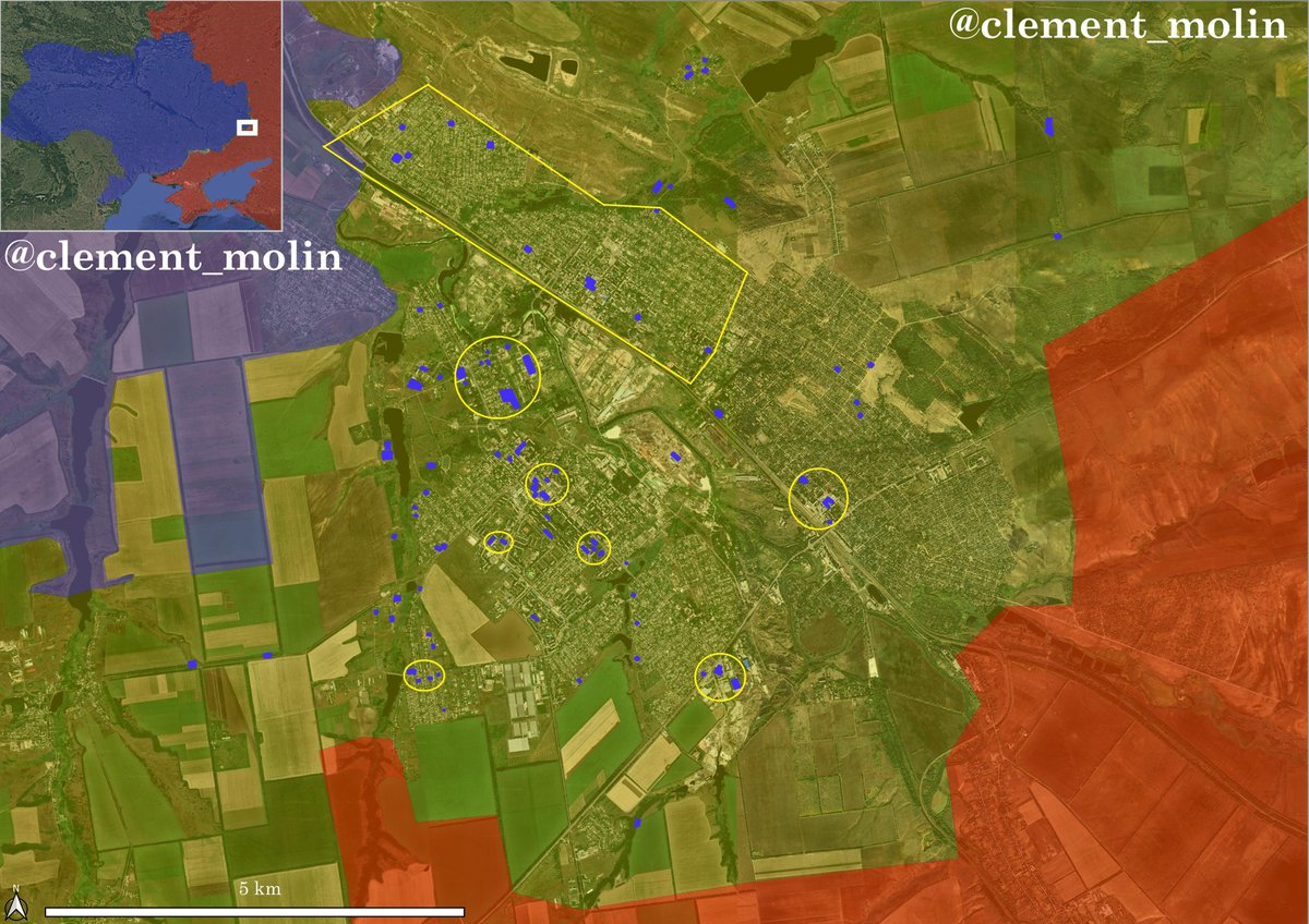
Here is a map for only Ukrainian positions recorded during the last 40 days in the city.
The big rectangle is an area under Ukrainian control, as there is a very large number of Ukrainian positions there, even if it's not very visible on this map. There are still many strongpoints in the city, especially covering infiltration routes.
The big rectangle is an area under Ukrainian control, as there is a very large number of Ukrainian positions there, even if it's not very visible on this map. There are still many strongpoints in the city, especially covering infiltration routes.
Russian forces have started consolidating in the red areas, while they have a visible and numerous presence in the city center and in the industrial area.
A big part of the lone dots are in fight flag videos, which means one soldier can be the source of 5 to 10 flags.
A big part of the lone dots are in fight flag videos, which means one soldier can be the source of 5 to 10 flags.
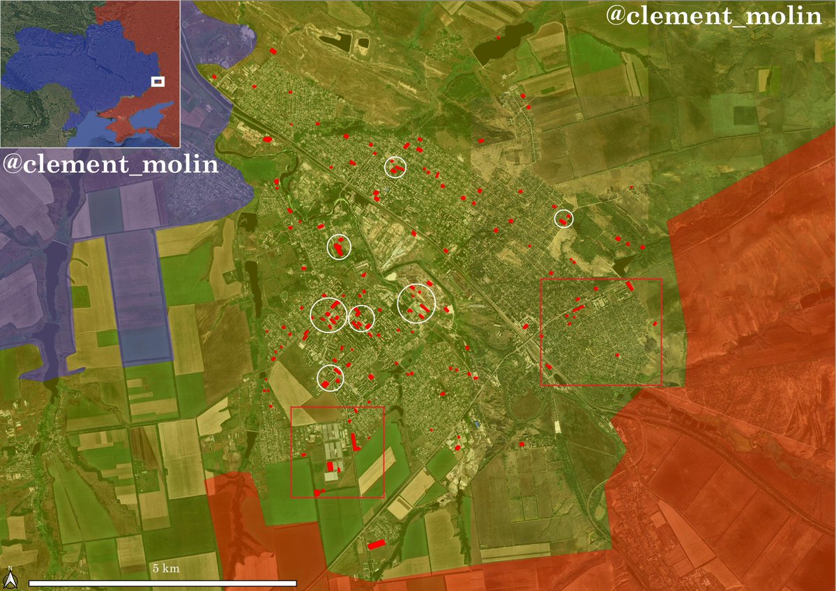
In the city center, Ukraine still controls very important positions along the main road, with UGV logistics still working.
Russia is gaining full control of multiple areas, including the industrial area and some high rise building.
The most important : THERE IS NO ENCIRCLEMENT OF ANYONE. The battle is dynamic, soldiers are hiding in basements and firefights are not happening often.
Russia is gaining full control of multiple areas, including the industrial area and some high rise building.
The most important : THERE IS NO ENCIRCLEMENT OF ANYONE. The battle is dynamic, soldiers are hiding in basements and firefights are not happening often.
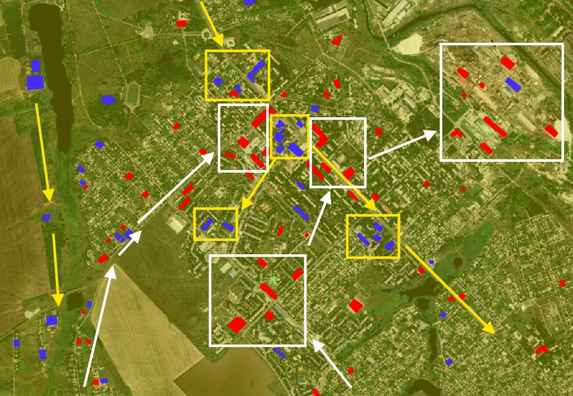
I don't like these kinds of maps, but here would be some kind of "influence areas", with more Russian/Ukrainian positions recorded in this western side of the city.

The situation on the western side of the city is much more difficult to map, since infiltrating Russians are hiding in small houses for days and weeks.
Ukraine continues to keep many soldiers in the more central part of the city, including in the high rise buildings.
Ukraine continues to keep many soldiers in the more central part of the city, including in the high rise buildings.

This shows how doing maps relying only on the geolocations you see/want to see is not reliable.
You can easily have two types of maps for the same situation, which is why there are some conflicts. Both are wrong btw.
You can easily have two types of maps for the same situation, which is why there are some conflicts. Both are wrong btw.

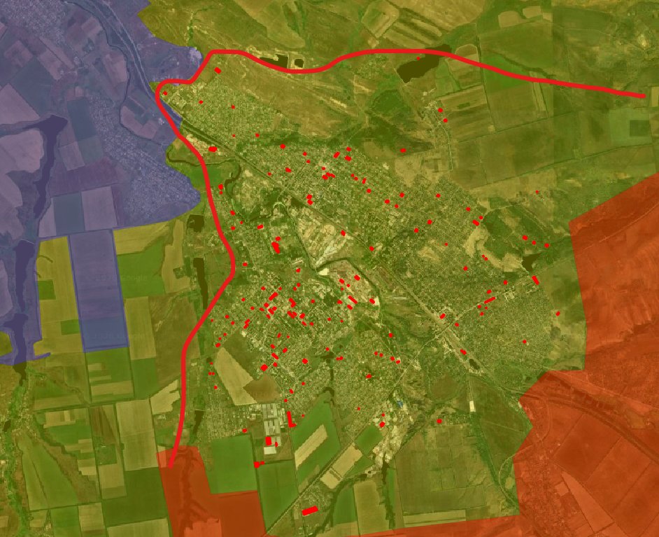
In my opinion, it is much better to put a grey zone (this one is too large, but you understood the idea).
Because you cannot ignore that there are Ukrainian soldiers (actively fighting) in the southern edge of the city, and you cannot ignore there are Russian infiltrators in the northern edge of the city.
Because you cannot ignore that there are Ukrainian soldiers (actively fighting) in the southern edge of the city, and you cannot ignore there are Russian infiltrators in the northern edge of the city.
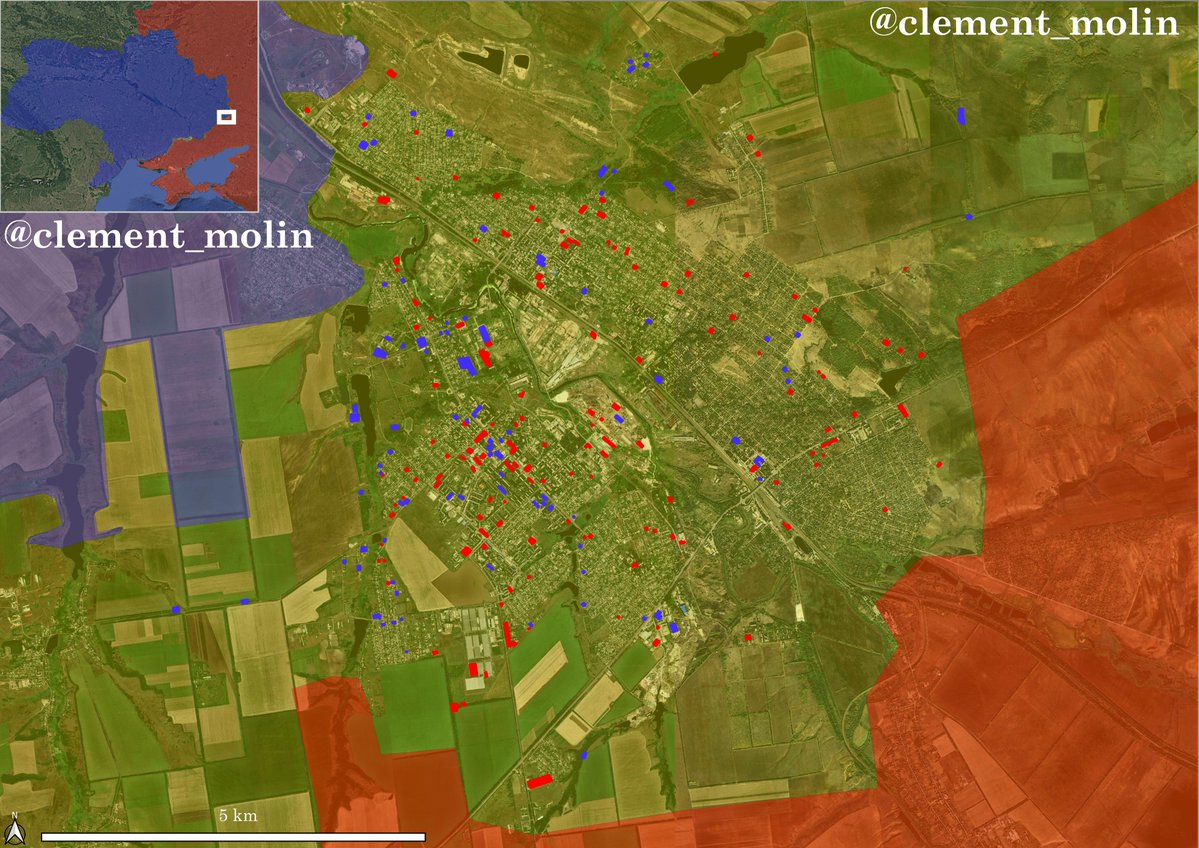
Thus, saying that Kostiantynivka fell is a mistake. The city has not yet fallen and Ukraine still has positions nearly everywhere, seen here with just July geolocations.

Now, let's talk about the situation in the city.
The city is lost, everyone knows that. But it is lost the same way Toretsk was lost in February 2025. After that, it took Russia nearly 8 months to have a full control over the city and to reach the next one, Kostiantynivka.
The city is lost, everyone knows that. But it is lost the same way Toretsk was lost in February 2025. After that, it took Russia nearly 8 months to have a full control over the city and to reach the next one, Kostiantynivka.
Here is what I was saying on June 10, a month and half ago when I was told Kostiantynivka was falling.
"It will take long months before total control". I say it again today. The battle will last until the end of summer, as announced.
"It will take long months before total control". I say it again today. The battle will last until the end of summer, as announced.
https://x.com/clement_molin/status/2064608714493927861?s=20
The situation will continue to worsen, Russian flaggers will appear in villages and towns north of the city and Ukrainian troops will slowly leave their positions in the city.
No one is encircled, no one controls anything except basements and buildings.
No one is encircled, no one controls anything except basements and buildings.
Thank you for following the situation with me.
If you want to debate with me about the situation, I will only reply to people showing me proofs (that I'm wrong) or arguments of why my methodology is incorrect.
Saying that this or that person said the contrary won't be enough.
If you want to debate with me about the situation, I will only reply to people showing me proofs (that I'm wrong) or arguments of why my methodology is incorrect.
Saying that this or that person said the contrary won't be enough.
• • •
Missing some Tweet in this thread? You can try to
force a refresh