
This is the Official Twitter handle of India Meteorological Department, Ministry of Earth Sciences, Government of India.
 shallow fog in isolated pockets over Assam & Meghalaya.


 Scattered to fairly widespread rainfall with isolated thunderstorm/lightning/gusty winds (speed reaching 40-50 kmph) during 03rd-06th May. Isolated hailstorm also likely over Himachal Pradesh & Uttarakhand on 03rd & 04th May, 2022.
 Isolated thunderstorm/lightning likely over Andaman & Nicobar Islands on 18th & 19th February. Strong surface winds speed reaching upto 30-40 kmph likely to prevail along & off Andaman & Nicobar Islands during next 24 hours. (2/8)
 Strong surface winds (20-30 kmph) likely along & off Andaman & Nicobar Islands during next 48 hours.

 Under the influence of two successive feeble Western Disturbances; isolated light rainfall/snowfall very likely over Jammu-Kashmir-Ladakh-Gilgit-Baltistan-Muzaffarabad during next 5 days and over Himachal Pradesh during 18th to 20th and over Uttarakhand on 20th Feb, 2022. 2/6


 near Lat. 12.6°N and Long 79.4°E, about 85 km north-northwest of Puducherry and about 95 km west-southwest of Chennai. It would continue to move northwestwards and weaken further into a Deep Depression during next 06 hours and into a Depression by subsequent 06 hours.
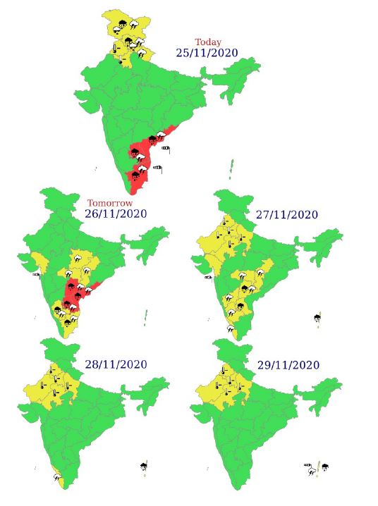 Isolated extremely heavy rainfall over coastal & north interior Tamilnadu & Puducherry (Thanjavur, Tiruvarur, Nagapattinam, Cuddalore, Chennai, Kanchipuram, Chengalpattu, Myladuthirai, Ariyalur, Perambalur, Kallakurchi, Villupuram, Tiruvannamalai, Puducherry and Karaikal) on 25th


 इसकी दूरी कुड्डालोर से लगभग 240 किमी पूर्व-दक्षिणपूर्व में, पुडुचेरी से लगभग 250 किमी पूर्व-दक्षिणपूर्व में और चेन्नई से 300 किमी दक्षिण-दक्षिणपूर्व में है। इसके तीव्र होकर अगले 06 घंटों के दौरान एक अत्यंत प्रचंड चक्रवाती तूफान में घनीभूत होने की संभावना है।


 इसकी दूरी कुड्डालोर से लगभग 320 किमी पूर्व में, पुडुचेरी से लगभग 350 किमी दक्षिण-पूर्व में और चेन्नई से 410 किमी पूर्व दक्षिण-पूर्व में है।