NashSevereWx Profile picture
Community Supported Local Weather, Nashville & Williamson Co ° @NashvilleScene Readers' Poll Best Twitter Acct '14-'22 ° 2016 & 2022 NWA W. J. Bennett Award
Dionysian Fandom Chick (she/her) Profile picture Roberta Ciuffo West Profile picture 2 subscribed
Feb 16, 2023 7 tweets 2 min read
Let's talk about how to view this severe weather event. Bear with this thread for some perspective. Some might ask, "is this event a slam dunk? Like, it's gonna happen, or no?" This ain't no on/off switch or a yes/no. (1/7) Forecasts like this work off probabilities. That's how we *have* to view these things. Until I see a probability map with 100% on it, nothing's a slam dunk. (That map doesn't exist). Here's how it works... (2/7)
Feb 16, 2023 7 tweets 4 min read
1/ 9pm update. | We're seeing some storms move up from the South currently. This gif of the 0z HRRR matches up with what's going on. It is "well initiated". The better the initiation the better the model run. Timing, 10p tonight - 8a Thurs. The gif below covers next 24hrs. 2/ Storms/Rain will increase in coverage overnight. The ingredients for severe weather are in place to our west and working their way here. This cannot be ignored. I won't get into the gritty details of effective bulk shear and CAPE here. Instead let's talk about probabilities.
Feb 15, 2023 4 tweets 2 min read
(1/4) Two rounds of severe weather are possible. Round 1: Tonight through tomorrow morning. Damaging straight-line winds are the main threat, but isolated tornadoes are also possible. Do not go to sleep tonight without multiple ways to get warnings. @stormwatchplus (2/4) Round 2: Thursday afternoon. *Depending* on how well the atmosphere recharges, we could see a higher threat of damaging winds and isolated tornadoes.
Jan 14, 2022 8 tweets 3 min read
Forecast is cold rain Saturday. Then Saturday night we see a changeover to wintry precip, then snow into Sunday until around dark.

This is not a universally agreed upon snow event (see below), most data thinks snow is coming so it was time for a Winter Storm Watch.

1/8
"Currently forecast snowfall accumulation amounts generally ranging from 3 to 7 inches across our area . . . potential for locally higher amounts than what is currently being forecasted is certainly possible." -@NWSNashville. A "deformation zone" may form across Middle TN...

2/8
Jan 13, 2022 6 tweets 1 min read
Looks like rain Saturday with a transition to wintry mix or snow late Saturday into Sunday. Forecast is a headache…. Rain, sleet and snow are all possible between Saturday and Sunday night with travel impacts potentially extending beyond that. (1/6) ^al NWS: “Get ready for winter weather and possible major travel impacts, but understand these winter storms are difficult to predict and change rapidly. Even small changes in the strength and track can mean huge changes in real-world impacts.” (2/6) ^al
Dec 9, 2021 9 tweets 3 min read
👀

Storm Prediction Center has increased the concern level for severe weather 👉🏽 Friday, likely late Friday night, overnight, into Saturday morning.

An 8:30 AM Thursday thread 🧵 about Hazards, Probability, Timing, & Preparedness Hazards - Tornado

The probability of a tornado within 25 miles of you is 10%.

Shaded area means some tornadoes could be strong, EF-2 or stronger. We are not squarely in the middle of this strong tornado risk area, but we’re in it.
Dec 8, 2021 4 tweets 2 min read
No cause for party or panic but behold the appearance of "snowshowers" in the forecast grid in the predawn hours Wednesday (cough, tomorrow) morning. 1/4 Image [insert your reply to the above tweet with an "other people will rush to the store and buy bread and milk" jokes, go ahead, you know you want to, they are always funny] 2/4
Aug 30, 2021 5 tweets 2 min read
Rainfall amounts through Wednesday morning could be 4-5 inches with isolated higher amounts to 6 inches possible. Make sure gutters and storm drains are clear so water can go where it's supposed to. Have a way to get flash flood warnings that'll wake you up. ^al (1/5) 
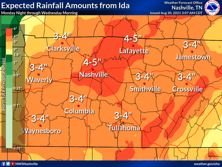
A Flash Flood Watch is in effect from 7:00 pm tonight through 1:00 am Wednesday Morning. ^al (2/5)
Mar 17, 2021 10 tweets 3 min read
Morning Update. All timing subject to change.

1/10

1. Storms are now lifting out of north MS and north AL. 2. The 11z run of HRRR model shows most of these storms will continue to move north, the bigger ones hitting west TN, during late morning/lunch. We will see rain late morning/lunchtime.

Then around 4-5 PM a line of stronger storms moves in.
Feb 11, 2021 8 tweets 2 min read
Davidson & Williamson Counties cover 1,110 sq. mi. Will Co's highest elevation is 1256 feet, Davidson's is 1160 feet. Temps vary by elevation. Roads go up and down hills. Some are shaded, some runoff water well. Where ice has formed, or may form, is as diverse as our community... ...therefore we know no specifics. General rules are helpful but not decisive. Wind helps dry roads. Roads at elevation are colder, but they got gravity on their side, water can run off. Treated roads will hold less ice than untreated roads. It appears...
Feb 10, 2021 5 tweets 1 min read
Remember in the summer, when it can be pouring down the street, but dry at your place? Same kinda thing incoming overnight about temps. Temp will be influenced by elevation and location: 34°, 33°, 32°, 31°, 30° will be scattered across our county. The average temp freezing line.. ...is expected to bisect Davidson and Williamson Counties. Note that we need 31° and 30° temps for a long time to cause ice accretion, but the problem is there is no indication where the hazards are. Icy roads will look wet, and wet roads will look icy. You can keep an eye on ..
Aug 9, 2020 12 tweets 5 min read
Today I read about Space Threats. Because 2020.

I was cleaning bookmarks. Came across weather.gov/safety/ National Weather Service Safety Tips.

You got Floods (ya), Lightning (nodding), Tornadoes, Hurricanes, etc. Feed me those tips.

But what was this? 1/12 Safety Tips for Space Weather? Um, is space threatening us?

I clicked the link hoping for tips about alien invasion (everyone dress like a stormtrooper), space thunderstorms (beam/teleport to alternate hemisphere), asteroids (Roman Josi slap shot)?

2/
Dec 9, 2019 7 tweets 2 min read
Technical forecast discussion from @NWSNashville just posted, describing several factors that could reduce or supplement 0.5" to 1" expected tomorrow. I hereby attempt to unpack it. A thread 1/ 2/ Some models think surface temps will drop only into the mid 30s, then stop there. Splat/Melt would "dramatically cut snow totals."
Mar 14, 2019 7 tweets 3 min read
Storm Update! 1 of 7. Two rounds (really, just one) of storms tomorrow.

ROUND ONE: fizzles shortly after midnight. HRRR model shows strong storms now in west Tennessee, but as they get to us in the pre-dawn hours tomorrow morning, they dissolve into weaksauce, no big deal. 2 of 7. The Euro model agrees, Round 1 of storms fizzles like an ice cube in boiling water. Even the NAM3 model agrees, ⬇️.
Feb 21, 2019 5 tweets 2 min read
Flooding Potential Update, 1 of 5. HRRR model this morning thru Friday 6 PM predicts about 1" for us. It *also* paints a "training" line of heavier rain dropping 2" to 2.5" into S. Will Co. This may shift. Where this "training" line actually sets up is key to flooding severity. 2 of 5. HRRR model only goes into Friday night. It's going to rain hard Saturday, too. The NAM3 model goes 24 hours further than the HRRR, into Saturday night. NAM3 has a "training" rain total up to 3.1" over a 48 hour period (Thu night thru Sat night).