
Christian, American, physician, scientist, musician, vegan, husband, dad. I'm devoted to sharing truth, with the goal of helping all of humankind. ✝️🌎🇺🇸


 What can transform large quantities of WTC building materials, including steel, into fine dust in midair, while sparing paper, aluminum, and certain other materials? You can clearly see this happening with your very own eyes in the following videos.


 Humankind has made a major scientific discovery by learning to manipulate matter using directed energy in a new and extremely powerful way. This is one of the most important scientific discoveries since the nuclear fission technology that was used to create the atomic bomb. It is an irrefutable fact that directed energy technology was used to transform the WTC buildings to fine dust in midair on 9/11/2001. This inescapable conclusion is revealed by the large and conclusive body of verifiable, physical evidence from 9/11, and is overwhelmingly proven beyond any reasonable doubt. I have already contacted numerous law enforcement agencies and government officials about this matter, including the FBI, branches of the military, my local sheriff's department, and several congressional representatives.


 What can transform large quantities of WTC building materials, including steel, into fine dust in midair, while sparing paper, aluminum, and certain other materials? You can clearly see this happening with your very own eyes in the following videos.


 Humankind has made a major scientific discovery by learning to manipulate matter using directed energy in a new and extremely powerful way. This is one of the most important scientific discoveries since the nuclear fission technology that was used to create the atomic bomb. It is an irrefutable fact that directed energy technology was used to transform large quantities of WTC building materials to fine dust in midair on 9/11/2001. This inescapable conclusion is revealed by the large and conclusive body of verifiable, forensic evidence from 9/11, and is overwhelmingly proven beyond any reasonable doubt.


 What can transform large quantities of WTC building materials, including steel, into fine dust in midair, while sparing paper, aluminum, and certain other materials? You can clearly see this happening with your very own eyes in the following videos.


 What can transform large quantities of WTC building materials, including steel, into fine dust in midair, while sparing paper, aluminum, and certain other materials? You can clearly see this happening with your very own eyes in the following videos.


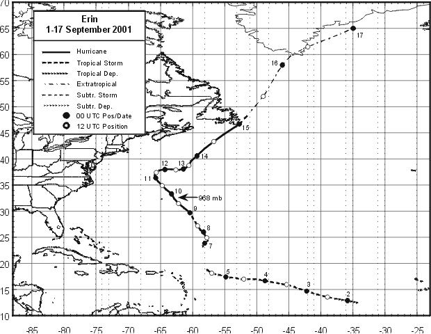
 Hurricane Erin (category 3) traveled in a straight line towards New York City for 4-5 days from September 7th-11th 2001, reaching its closest point to land, just off the coast, on the morning of 9/11/2001. Despite Hurricane Erin's threatening trajectory, we suspiciously weren't warned by most corporate news broadcasts in the days leading up to 9/11, or on the morning of 9/11. When most corporate news channels displayed schematic weather maps of the northeast U.S. coastline, Hurricane Erin was not shown. Hurricane Erin was similar in size to Hurricane Katrina and similar in strength to Hurricane Sandy (category 3), and hurricanes rarely head straight for NYC, yet we weren't warned by most corporate news outlets that Hurricane Erin was heading straight for densely populated New York City.


 Hurricane Erin (category 3) traveled in a straight line towards New York City for 4-5 days from September 7th-11th 2001, reaching its closest point to land, just off the coast, on the morning of 9/11/2001. Despite Hurricane Erin's threatening trajectory, we suspiciously weren't warned by most corporate news broadcasts in the days leading up to 9/11, or on the morning of 9/11. When most corporate news channels displayed schematic weather maps of the northeast U.S. coastline, Hurricane Erin was not shown. Hurricane Erin was similar in size to Hurricane Katrina and similar in strength to Hurricane Sandy (category 3), and hurricanes rarely head straight for NYC, yet we weren't warned by most corporate news outlets that Hurricane Erin was heading straight for densely populated New York City.


 Hurricane Erin (category 3) traveled in a straight line towards New York City for 4-5 days from September 7th-11th 2001, reaching its closest point to land, just off the coast, on the morning of 9/11/2001. Despite Hurricane Erin's threatening trajectory, we suspiciously weren't warned by most corporate news broadcasts in the days leading up to 9/11, or on the morning of 9/11. When most corporate news channels displayed schematic weather maps of the northeast U.S. coastline, Hurricane Erin was not shown. Hurricane Erin was similar in size to Hurricane Katrina and similar in strength to Hurricane Sandy (category 3), and hurricanes rarely head straight for NYC, yet we weren't warned by most corporate news outlets that Hurricane Erin was heading straight for densely populated New York City.


 Hurricane Erin (category 3) traveled in a straight line towards New York City for 4-5 days from September 7th-11th 2001, reaching its closest point to land, just off the coast, on the morning of 9/11/2001. Despite Hurricane Erin's threatening trajectory, we suspiciously weren't warned by most corporate news broadcasts in the days leading up to 9/11, or on the morning of 9/11. When most corporate news channels displayed schematic weather maps of the northeast U.S. coastline, Hurricane Erin was not shown. Hurricane Erin was similar in size to Hurricane Katrina and similar in strength to Hurricane Sandy (category 3), and hurricanes rarely head straight for NYC, yet we weren't warned by most corporate news outlets that Hurricane Erin was heading straight for densely populated New York City.


 Most people do not understand the 9/11 attacks as well as they think they do, including most 9/11 “truthers.” Please study the following evidence and draw your own conclusions. 🧵 THREAD


 Hurricane Erin (category 3) traveled in a straight line towards New York City for 4-5 days from September 7th-11th 2001, reaching its closest point to land, just off the coast, on the morning of 9/11/2001. Despite Hurricane Erin's threatening trajectory, we suspiciously weren't warned by most corporate news broadcasts in the days leading up to 9/11, or on the morning of 9/11. When most corporate news channels displayed schematic weather maps of the northeast U.S. coastline, Hurricane Erin was not shown. Hurricane Erin was similar in size to Hurricane Katrina and similar in strength to Hurricane Sandy (category 3), and hurricanes rarely head straight for NYC, yet we weren't warned by most corporate news outlets that Hurricane Erin was heading straight for densely populated New York City.


 Hurricane Erin (category 3) traveled in a straight line towards New York City for 4-5 days from September 7th-11th 2001, reaching its closest point to land, just off the coast, on the morning of 9/11/2001. Despite Hurricane Erin's threatening trajectory, we suspiciously weren't warned by most corporate news broadcasts in the days leading up to 9/11, or on the morning of 9/11. When most corporate news channels displayed schematic weather maps of the northeast U.S. coastline, Hurricane Erin was not shown. Hurricane Erin was similar in size to Hurricane Katrina and similar in strength to Hurricane Sandy (category 3), and hurricanes rarely head straight for NYC, yet we weren't warned by most corporate news outlets that Hurricane Erin was heading straight for densely populated New York City.


 Most people do not understand the 9/11 attacks as well as they think they do, including most 9/11 “truthers.” Please study the evidence in the following THREAD and draw your own conclusions. 🧵


 Most people do not understand the 9/11 attacks as well as they think they do, including most 9/11 “truthers.” Please study the evidence samples in this thread and draw your own conclusions. 🧵


 Hurricane Erin (category 3) traveled in a straight line towards New York City for 4-5 days from September 7th-11th 2001, reaching its closest point to land, just off the coast, on the morning of 9/11/2001. Despite Hurricane Erin's threatening trajectory, we suspiciously weren't warned by most corporate news broadcasts in the days leading up to 9/11, or on the morning of 9/11. When most corporate news channels displayed schematic weather maps of the northeast U.S. coastline, Hurricane Erin was not shown. Hurricane Erin was similar in size to Hurricane Katrina and similar in strength to Hurricane Sandy (category 3), and hurricanes rarely head straight for NYC, yet we weren't warned by most corporate news outlets that Hurricane Erin was heading straight for densely populated New York City.


 Hurricane Erin (category 3) traveled in a straight line towards New York City for 4-5 days from September 7th-11th 2001, reaching its closest point to land, just off the coast, on the morning of 9/11/2001. Despite Hurricane Erin's threatening trajectory, we suspiciously weren't warned by most corporate news broadcasts in the days leading up to 9/11, or on the morning of 9/11. When most corporate news channels displayed schematic weather maps of the northeast U.S. coastline, Hurricane Erin was not shown. Hurricane Erin was similar in size to Hurricane Katrina and similar in strength to Hurricane Sandy (category 3), and hurricanes rarely head straight for NYC, yet we weren't warned by most corporate news outlets that Hurricane Erin was heading straight for densely populated New York City.


 Hurricane Erin (category 3) traveled in a straight line towards New York City for 4-5 days from September 7th-11th 2001, reaching its closest point to land, just off the coast, on the morning of 9/11/2001. Despite Hurricane Erin's threatening trajectory, we suspiciously weren't warned by most corporate news broadcasts in the days leading up to 9/11, or on the morning of 9/11. When most corporate news channels displayed schematic weather maps of the northeast U.S. coastline, Hurricane Erin was not shown. Hurricane Erin was similar in size to Hurricane Katrina and similar in strength to Hurricane Sandy (category 3), and hurricanes rarely head straight for NYC, yet we weren't warned by most corporate news outlets that Hurricane Erin was heading straight for densely populated New York City.


 Hurricane Erin (category 3) traveled in a straight line towards New York City for 4-5 days from September 7th-11th 2001, reaching its closest point to land, just off the coast, on the morning of 9/11/2001. Despite Hurricane Erin's threatening trajectory, we suspiciously weren't warned by most corporate news broadcasts in the days leading up to 9/11, or on the morning of 9/11. When most corporate news channels displayed schematic weather maps of the northeast U.S. coastline, Hurricane Erin was not shown. Hurricane Erin was similar in size to Hurricane Katrina and similar in strength to Hurricane Sandy (category 3), and hurricanes rarely head straight for NYC, yet we weren't warned by most corporate news outlets that Hurricane Erin was heading straight for densely populated New York City.


 Hurricane Erin (category 3) traveled in a straight line towards New York City for 4-5 days from September 7th-11th 2001, reaching its closest point to land, just off the coast, on the morning of 9/11/2001. Despite Hurricane Erin's threatening trajectory, we suspiciously weren't warned by most corporate news broadcasts in the days leading up to 9/11, or on the morning of 9/11. When most corporate news channels displayed schematic weather maps of the northeast U.S. coastline, Hurricane Erin was not shown. Hurricane Erin was similar in size to Hurricane Katrina and similar in strength to Hurricane Sandy (category 3), and hurricanes rarely head straight for NYC, yet we weren't warned by most corporate news outlets that Hurricane Erin was heading straight for densely populated New York City.


 Hurricane Erin (category 3) traveled in a straight line towards New York City for 4-5 days from September 7th-11th 2001, reaching its closest point to land, just off the coast, on the morning of 9/11/2001. Despite Hurricane Erin's threatening trajectory, we suspiciously weren't warned by most corporate news broadcasts in the days leading up to 9/11, or on the morning of 9/11. When most corporate news channels displayed schematic weather maps of the northeast U.S. coastline, Hurricane Erin was not shown. Hurricane Erin was similar in size to Hurricane Katrina and similar in strength to Hurricane Sandy (category 3), and hurricanes rarely head straight for NYC, yet we weren't warned by most corporate news outlets that Hurricane Erin was heading straight for densely populated New York City.


