Gabe Garfield Profile picture
Meteorologist & storm chaser | Helping chasers find tornadoes | Posts about tornadoes, forecasting, and science | https://t.co/Q29jjA5f69
Aug 26, 2025 13 tweets 5 min read
The most violent tornadoes can produce winds in excess of 300 mph.

What's wild, is that theoretically, these winds can be even stronger.

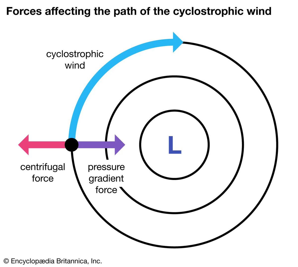
Here's the atmospheric process that makes this possible: 1/12 Tornadoes are assumed to be in cyclostrophic balance. This means that, as the tornado spins, air doesn't converge toward the funnel or diverge away from it.

Two forces generate this pseudo-equilibrium:

-Pressure gradient force
-Centrifugal force

(Image: Brittanica)

2/12 Image
Jan 12, 2025 6 tweets 2 min read
On 5/24/11, this EF4 tornado hit areas near Criner & Goldsby, OK.

Despite its narrowness, this vortex displayed incredible power.

It leveled houses completely, tossed vehicles extreme distances, and caused some of the most severe ground scouring I've ever surveyed. 1/6 The day after the tornado, I assisted the National Weather Service in conducting a damage survey.

We observed many homes that had been leveled, with one of the most severely affected located near Criner.

2/6 Image
Jan 3, 2025 10 tweets 3 min read
Officially, the Houston-Port Arthur long-track EF3 tornado tracked 48 miles and lasted 78 minutes.

But there is reason to believe that it could have been longer – potentially much longer. 🧵

1/9 Image The start of the tornado is taken to be 10 South of Anahuac to 5 south of Port Arthur.

Time: 2:35-3:53p CST
Distance: 41 miles

2/9 Image
Dec 18, 2024 13 tweets 5 min read
In storm chasing, overconfidence can be deadly.

On April 13, 2012, we saw this rather unimpressive storm near Cooperton, Oklahoma. It was "only" severe-warned, so we decided to enter the Bear's Cage to see what was inside the rain.

Here's what happened next:

1/12 Image We punched north through a high-precip supercell near Cooperton, OK and saw this low visibility tornado.

It didn't seem like a bad choice...

2/12
Feb 18, 2024 9 tweets 3 min read
Routines for forecasting tornadoes vary from person to person.

I prefer a basic approach -- at least at the outset.

I start by looking at map charts to understand the big picture. Then I dig into the details with forecast soundings.

Here's how it works:

1/9 500 mb

Here I look for a few things:

*Longwave troughs - large dips in the height contours
* Shortwave troughs - flow >25 kts
* Flow geometry - tilt of trough/ridge, meridional vs zonal flow

2/9 Image
Feb 11, 2024 25 tweets 9 min read
I’ve chased tornadoes for almost 25 years. And in that time, only one has ever chased me.

It was, of course, the El Reno, OK tornado of 5/31/13.

It was 2.6 miles at its widest, had winds > 300 mph, and moved faster than 50 mph.

For the first time, here is my full story:

1/25 To be honest, I really wasn't aware of how volatile it looked until it came.

Reason being, the weather had been crazy. I'd been chasing more than a half-dozen times since May 18th.

And frankly, I was exhausted. I wasn't very interested in forecasting.

2/25 Image
Dec 15, 2023 11 tweets 4 min read
It has taken me 11 years to post this.

On 4/13/12, an aggressive chase maneuver I made almost ended badly.

We punched north through a high-precip supercell near Cooperton, OK and saw this low visibility tornado. It didn't seem like a bad choice...

1/11 ... because the tornado was moving northeast -- or at worst, east. We were south of it, so I figured we were safe.

And since the contrast was getting worse, I asked our crew to inch closer for a better view.

2/11