Brady Africk Profile picture
Maps and satellite imagery 🛰🌻🔭 | @AEIfdp media relations | Tweets and opinions are my own
Beki Thomson✨ Profile picture Joby1960🇪🇺🇬🇧 #FBPE 3.5% Proud Do Gooder Profile picture Ruben Chagaray Profile picture UnkleBobby Profile picture Scott Profile picture 7 subscribed
Apr 26 5 tweets 2 min read
Russia transformed its border with Ukraine over the past two years with multiple lines of defenses.

Russian forces continue expanding fortifications along this border and within occupied Ukraine. This update adds newly mapped Russian positions found in satellite imagery. (1/5) Image 
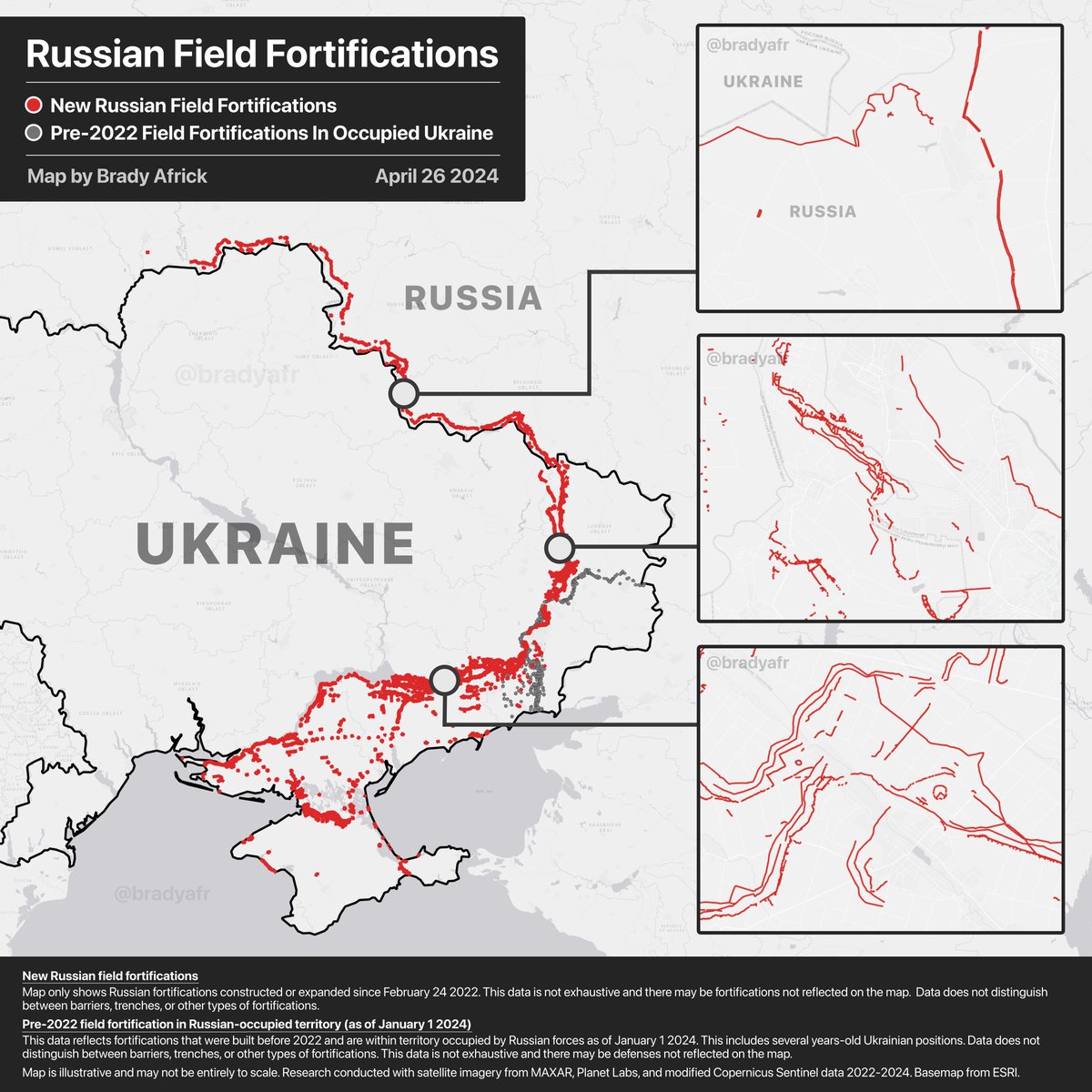
An example of Russia expanding defenses along the border with Ukraine is visible near Pokachevo (Belgorod oblast) where new fortifications were recently constructed. (2/5)
Jan 30 8 tweets 3 min read
As Ukrainian long-range strike capabilities have grown, so has the number of decoys at Russian air bases involved in the invasion of Ukraine.

This thread shows several of the decoys Russian forces have painted at air bases that were once beyond Kyiv’s reach. (1/8) Image Last summer, I noticed new activity at Russia’s Yeysk air base.

Russia was creating plane-like shapes at the base and these white “canvases” were later painted to resemble Russian fighter jets. (2/8)
Oct 1, 2023 5 tweets 2 min read
Russian forces expanded fortifications along the border with Ukraine in recent months.

This updated map shows many of these new defenses and links them to satellite imagery. (1/5) Image 
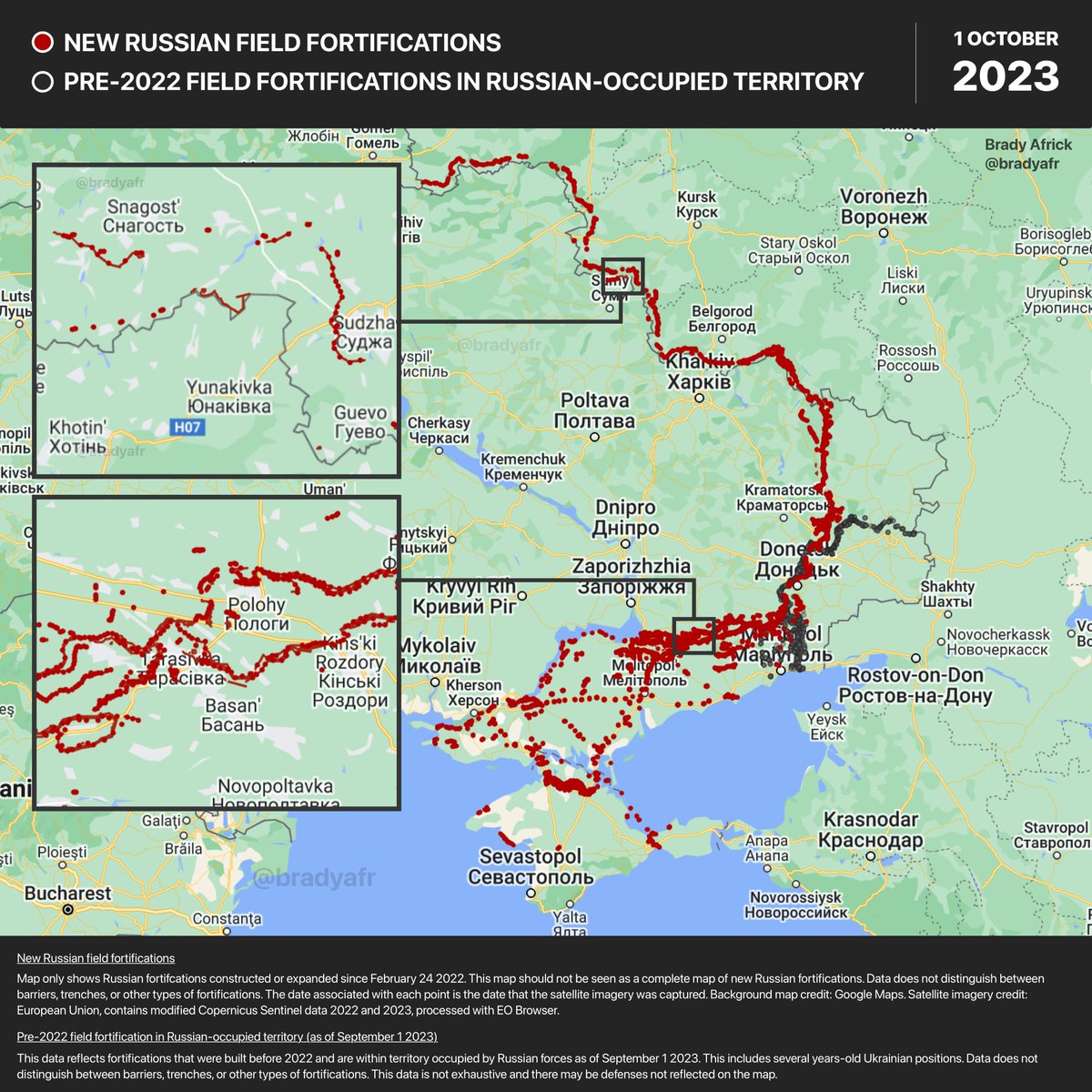
In Kursk oblast, new trenches were constructed over the summer along the border with Ukraine. (2/5)
Sep 10, 2023 5 tweets 2 min read
As Ukraine pushes south into occupied territory, Russian forces are bolstering defenses built in late 2022 and early 2023.

This updated map shows many of Russia's new defenses and links each to satellite imagery. (1/5) Image Russian forces near Ivana Franka (Zaporizhzhia oblast) built new trenches and barriers near existing defenses.

These positions are less than 10 kilometers from the front line. (2/5)
Aug 6, 2023 5 tweets 2 min read
Throughout the summer, Russian forces have worked to close gaps in their defensive lines and expand existing fortifications along highways in occupied Ukraine.

This updated map shows many of Russia's new fortifications and links each to satellite imagery. (1/5) Image In Zaporizhzhia oblast, Russian forces expanded fortifications outside Andriivka.

These defenses intersect the T0815 highway which leads further south in Russian-occupied Ukraine. (2/5)
Jul 22, 2023 4 tweets 2 min read
Russian forces in Ukraine continue to expand defenses along the front line.

This updated map shows many of Russia's new fortifications and links each to satellite imagery. (1/4) Image Near Lysychansk (Luhansk Oblast), Russian forces added new trenches and barriers along roads leading toward the city. (2/4)
Jul 7, 2023 4 tweets 2 min read
As Ukraine’s counteroffensive continues, Russian forces are building additional layers of defenses in occupied territory.

This updated map shows many of Russia's new fortifications and links each to satellite imagery. (1/4) In southern Ukraine, Russian forces are expanding defenses along roads leading south into occupied territory.

These fortifications near Vilne (Donetsk Oblast) are between the front line and the occupied city of Mariupol. (2/4)
May 27, 2023 9 tweets 2 min read
In eastern Ukraine, many of the defensive lines built by pro-Russian and Ukrainian forces during fighting between 2014 and 2022 are now inside Russian-occupied territory.

This map update shows where these older fortifications overlap with newer defenses. (1/8) Image 
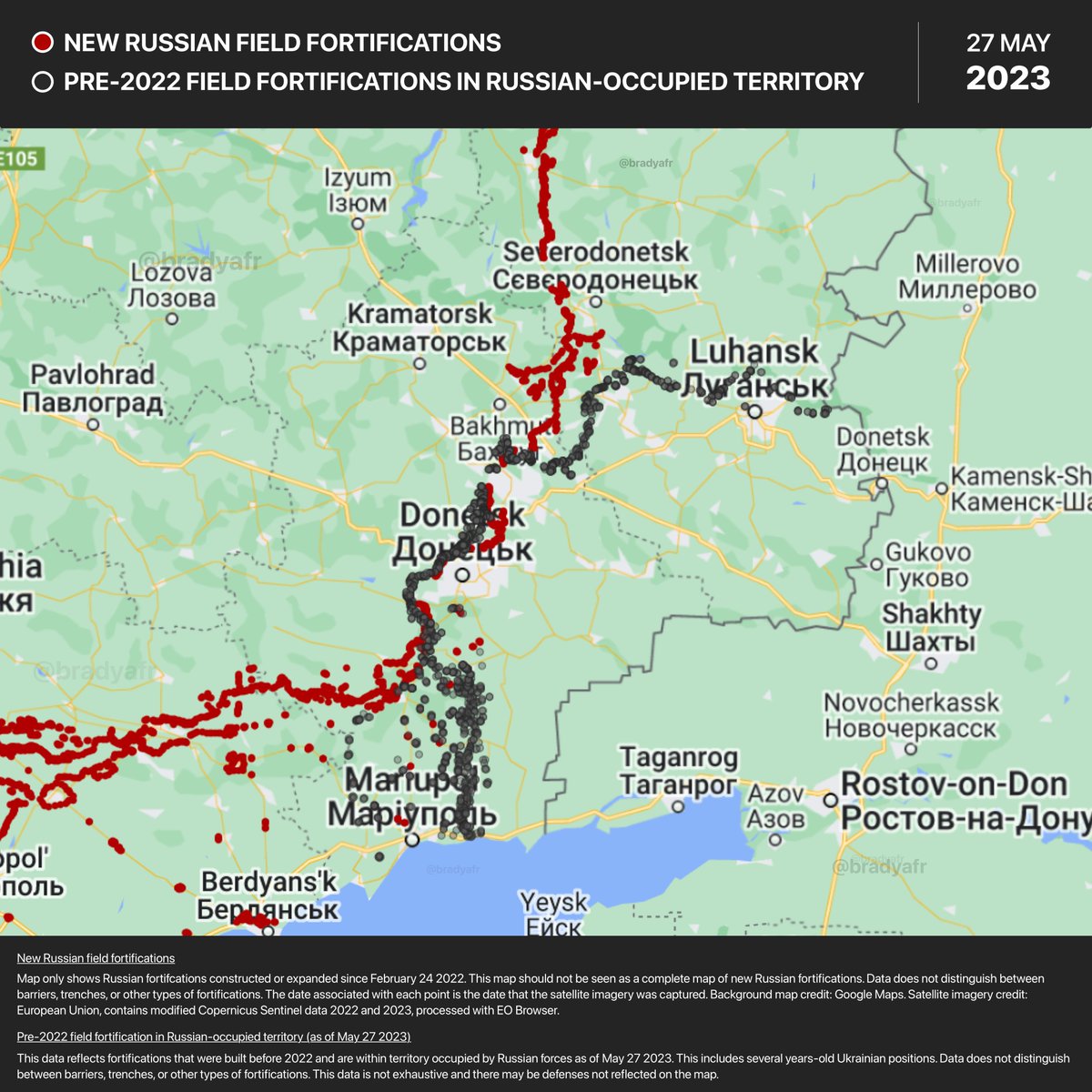
A few important notes on this map of fortifications in eastern Ukraine from 2014 to 2022:

First, this data only reflects trenches, barriers, and revetments built before February 2022 that are now within territory occupied by Russian forces. (2/8)
Apr 28, 2023 7 tweets 2 min read
A thread of Russian defensive lines in Ukraine as seen from satellite imagery.

To see more, check out the interactive map and full collection of high resolution imagery here: read.bradyafrick.com/p/russian-fiel… Image Russian trenches under construction near Olhynka in Donetsk Oblast. Image
Apr 9, 2023 8 tweets 3 min read
An updated thread on Russia’s fortifications in occupied Ukraine.

This interactive map shows the extent of their construction and links each point to satellite imagery: google.com/maps/d/edit?mi… (1/8) Image Important notes for this map:

1) This map should not be seen as a complete list of Russia's fortifications.
2) The data does not distinguish between different types of fortifications.
3) Only defenses constructed since Russia’s full-scale invasion last year are included.

(2/8)
Apr 5, 2023 4 tweets 2 min read
Russian forces have moved equipment out of a military depot in northern Crimea over the past month. Recent satellite imagery shows that this site had tanks, armored vehicles, and artillery. High resolution imagery from @Maxar and @washingtonpost shows some of the equipment at this Russian military depot and the defenses built nearby.

Russian forces constructed several fortifications near this site and throughout occupied Crimea: washingtonpost.com/world/interact… Image
Mar 14, 2023 6 tweets 3 min read
New satellite imagery shows that Russian forces have ramped up the construction of fortifications across occupied regions of Ukraine.

Check out a map of Russia’s field fortifications here: google.com/maps/d/edit?mi… (1/6) Image In Luhansk oblast, Russian forces have dug new trenches outside occupied cities. For example, these defenses outside Lysychansk were built in the past few months (2/6)
Mar 6, 2023 8 tweets 3 min read
Russian forces have expanded several air bases since launching the full-scale invasion of Ukraine.


This thread highlights some of the changes made to air bases inside Russian territory, as well as those in occupied regions of Ukraine. (1/8) Image Millerovo air base is used by Russian aircraft for operations over eastern Ukraine. Late last year, new helipads and areas for vehicles were added to the base. (2/8)
Feb 14, 2023 6 tweets 3 min read
Russian forces are doubling down on defenses across southern Ukraine in expectation of a spring counteroffensive.

This thread shows some of the areas where Russia has recently built fortifications. Check out a map of Russia’s fortifications here: google.com/maps/d/edit?mi… (1/6) About 15 kilometers from the front line, Russian forces added new layers to defenses near Tarasivka (Zaporizhizhia Oblast). (2/6)
Jan 27, 2023 6 tweets 3 min read
Russian forces continue to expand their sprawling lines of fortifications in Ukraine.

This update adds new sites to the interactive map and links each to satellite imagery. Check out the full map here: google.com/maps/d/edit?mi… (1/6) A few important notes for this updated map of Russian field fortifications:

1) This map should not be seen as a complete list of Russia's fortifications.
2) The data does not distinguish between barriers, trenches, or other types of fortifications.

(2/6)
Jan 21, 2023 4 tweets 2 min read
Russian forces in Ukraine have built hundreds of kilometers of field fortifications over the past few months.

This interactive map shows where many of these sites are located and links each to satellite imagery. (1/4)
google.com/maps/d/edit?mi… Important notes for this map of Russian field fortifications in Ukraine:

1) This map is not exhaustive and should not be seen as a complete map of Russia's fortifications.
2) The data does not distinguish between barriers, trenches, or other types of fortifications.

(2/4)
Sep 30, 2022 6 tweets 2 min read
The recent sabotage of the Nord Stream pipelines highlights the threat posed by attacks on critical undersea infrastructure.

The submerged internet cables that keep the world connected could be a tempting target for rogue actors. (1/6) Image A few severed cables would have far less impact on highly-connected nations than it could on smaller countries, which may rely on fewer points of connection. (2/6)
Jun 21, 2022 6 tweets 2 min read
A drilling platform on fire in the Black Sea is visible in satellite imagery from today. Image
Mar 8, 2022 15 tweets 4 min read
Thread on NASA's Fire Information for Resource Management System (FIRMS) and notable fires/thermal anomalies in Ukraine.

FIRMS offers near real-time data within hours of satellite observation (more here: earthdata.nasa.gov/earth-observat…). Image Important notes for use in this context:

1) FIRMS data alone should never be considered proof of a clash or strike.
2) FIRMS cannot tell you what started a fire.
3) As always, poor weather can hinder detection.