Daniel A. Walker 🇨🇦🇺🇦🌻😷💉🚴🏻 Profile picture
Retired geoscientist. 🪨💦⚒️🧭🗺️📈. Mineral exploration. Investigation and remediation of contaminated soil/water/sediment. PhD in hydrogeology.
Dec 18, 2023 4 tweets 4 min read
@emilyakopp Offshoring of risky virological lab work to countries with lower or zero biosafety requirements is an old strategy.
Lassa/Ebola lab, Kenema Government Hospital, Sierra Leone.


reuters.com/article/us-bio…
who.int/news-room/feat…
ncbi.nlm.nih.gov/pmc/articles/P…
vhfc.org


Image
Image
Image
@emilyakopp Ebola at BSL-2.
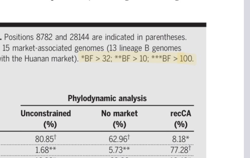

Supplementary Figure 1A. ncbi.nlm.nih.gov/pmc/articles/P…
ncbi.nlm.nih.gov/pmc/articles/P…

Image
Image
Apr 11, 2023 8 tweets 2 min read
Anyone who believes that China has or will provide reliable data to elucidate the origin of COVID should carefully study the statements made in this April 8 press conference.
Links to full conference appended.
@Ayjchan @JamieMetzl @mvankerkhove @mstandaert
news.cgtn.com/news/2023-04-0… Entire press conference with voice-over English translation of Standard Chinese (54m)
news.cgtn.com/news/2023-04-0…
Nov 24, 2022 23 tweets 9 min read
The geospatial analysis in Worobey2022 relies on a centering model to determine the origin point of COVID in Wuhan Dec 2019.
This model is not valid.
doi.org/10.1126/scienc… The centering model can be stated as follows: the spatial pattern of the home residence of severe cases is centered on the origin point, with spatial density decreasing away from the origin point.
Aug 27, 2022 25 tweets 9 min read
This thread examines two claims in Worobey et al:
Dec-2019 COVID case-residences in Wuhan were not concentrated in (1) areas of high population density or (2) areas with a high proportion of older persons.
science.org/doi/10.1126/sc… The specific claims in Worobey et al:
🌐Dec-2019 cases did not reside in areas with high population density of (1) all age groups or (2) older persons.
🌐Fig 1E, S9 and S10 are enlisted to support the claims.
Aug 19, 2022 41 tweets 16 min read
This thread addresses the claim in Worobey et al that KDE analysis shows centering of Dec 2019 COVID case-residences on the Huanan Market.
science.org/doi/10.1126/sc…
This apparent centering is an artifact due to use of an overly-large bandwidth in the KDE calculation. Image Adjusting the bandwidth parameter to more realistic values shifts the center of the KDE pattern away from the Huanan market, to an neighbourhood north of the market where there truly is a significant cluster of case-residences. Image
Aug 15, 2022 14 tweets 6 min read
Worobey et al. (2022)
science.org/doi/10.1126/sc…
Consider the KDE probability contours for the residences of Dec 2019 cases.
Data from zenodo.org/record/6908012…
*Linked* cases in green.
The map of the linked-cases KDE was omitted from the article... Image ...although the KDEs for all-cases and unlinked-cases were prominently displayed on Fig. 1, and featured in various tweets emitted by the authors. Image
Jun 10, 2022 8 tweets 5 min read
COVID-in-wastewater for BC Lower Mainland, to 4-June-2022. 🪡
From bccdc.ca/Health-Info-Si…
Red line at zero level added to emphasize that relatively high levels persist in wastewater, discordant with the low level of officially reported cases. (1/n)
#covid19bc Image The graph is dominated by the Jan-Dec peak, which effectively and conveniently scales down the current persistent high levels. The eye tends not to catch that the levels post-peak are much higher than the levels before. (2/n) Image
Jun 2, 2022 13 tweets 10 min read
(1/n) I can’t reply directly to this @angie_rasmussen tweet, promoting the famous epicenter preprint, now under peer review.
But I can re-up my critique.
TLDR: preprint gets an F, due to problems with math, cartography, and spatial analysis.
Sorry, nothing about furin cleavage. (2/n) The main fallacies
▪️Centrality is not causality.
▪️Simplification is not analysis.
▪️The spread of a complex disease in a complex city of 11 million cannot be reduced to a model of diffusion in a homogeneous, isotropic medium.
bit.ly/36KRtNX
Jun 1, 2022 6 tweets 5 min read
So, this is where we are in BC.
▪️COVID still rampant, although we only know that from wastewater measurements @YVRCovidPlots.
▪️16,000 HCWs off sick at least 1 day last week, as per @adriandix.
▪️Doctors and such holding in-person, maskless conferences. @BCPSQC @DoctorsOfBC
May 31, 2022 6 tweets 3 min read
Health Minister Dix says in Legislature that 16,000 HCWs were off sick at least 1 day last week.
Unclear whether all BC or just Interior Health.
He says “that’s because of COVID”. Not clear what he meant.
leg.bc.ca/documents-data…
@PennyDaflos @Protect_BC @VicLeungIDdoc This was reported in Saanich News (via CP?), but they say the absences were “due to COVID-19”, which is not quite what Dix said.
16,000 absences among BC HCWs in one week sounds crazy, given that there were only 1,358 official cases in all of BC May 15-21.
saanichnews.com/news/b-c-start…
May 1, 2022 41 tweets 15 min read
A thread to tie together and build on a series of previous threads, describing the methodological and conceptual errors in the geospatial analysis in the preprint
zenodo.org/record/6299600… [V2 of this thread; 1st version was broken after 3rd tweet, just before all the good stuff] Image Due to these errors, the preprint does not support its claim of dispositive evidence for emergence of SARS-COV-2 via life wildlife trade, or its claim that the Huanan market is the unambiguous “epicenter” of the COVID-19 pandemic. Image
Apr 5, 2022 23 tweets 8 min read
This thread discusses the claim in Worobey et al (2022) that, if the Huanan market was where the pandemic began, then the Dec 2019 COVID case-residences should be centered on the market. zenodo.org/record/6299116… @MichaelWorobey @acritschristoph @K_G_Andersen @stuartjdneil @edwardcholmes @arambaut @carlzimmer @PeaseRoland @amymaxmen
Mar 31, 2022 16 tweets 6 min read
This thread discusses the incorrect application of the concept of centroid in Worobey et al (2022), as applied to spatial analysis of locations of residences of serious cases of COVID in Wuhan in Dec 2019. zenodo.org/record/6299116… @MichaelWorobey @acritschristoph @K_G_Andersen @stuartjdneil @edwardcholmes @arambaut @carlzimmer @PeaseRoland @amymaxmen
Mar 29, 2022 25 tweets 10 min read
This thread discusses significant imprecision and errors in Worobey et al (2022), with respect to locations of residences of cases of COVID in Wuhan in Dec 2019. zenodo.org/record/6299116… @MichaelWorobey @acritschristoph @K_G_Andersen @stuartjdneil @edwardcholmes @arambaut @carlzimmer @PeaseRoland @amymaxmen
Mar 21, 2022 24 tweets 11 min read
This thread is a critique of the claim in Worobey et al. (2022) that the distribution of earliest known COVID-19 case-residences in Wuhan during Dec 2019 cannot be explained by population density of elderly persons.
zenodo.org/record/6299600
See also @MichaelWorobey @acritschristoph @K_G_Andersen @stuartjdneil @edwardcholmes @arambaut @carlzimmer @PeaseRoland @amymaxmen
with kudos to @MichaelWorobey for his career as a rapattack firefighter in BC...
Mar 3, 2022 18 tweets 9 min read
There is no scientific merit to the use of a simplified heatmap (kernel density estimate) to represent residential addresses of early COVID cases in Worobey et al (2022)
zenodo.org/record/6299600.
@MichaelWorobey @acritschristoph @K_G_Andersen @stuartjdneil
@edwardcholmes @arambaut This simplified image is important because it is used to lead the various Twitter threads that have been put out by the authors, and was featured in a New York Times article. Taken alone, it is a convincing graphic.
Dec 11, 2021 11 tweets 10 min read
This thread addresses certain statements in the article
newrepublic.com/article/164688… by @beyerstein.

The article is sharply critical of the book by @Ayjchan and @mattwridley, but fails to shine that critical light on some of its own claims.

See also . The reanalysis cited is science.org/doi/10.1126/sc… by @MichaelWorobey
I have previously addressed deficiencies in the map-based argumentation in this paper, at .
I have also addressed similar argumentation in another paper at
Nov 19, 2021 18 tweets 9 min read
1. This thread discusses Fig 1 of Worobey (2021), and particular the claim that this map shows a concentration of early COVID cases around the Huanan market in Wuhan, China.
I am a retired geologist. I have been making and interpreting maps since 1977.

science.org/doi/10.1126/sc… 2. This thread mainly consists of responses that I made to this tweet from @MichaelWorobey, gathered together and revised as a thread so as to form a coherent sequential discussion.
Sep 18, 2021 23 tweets 10 min read
1. This thread presents concerns regarding Fig 1B-E of Holmes et al 2021

cell.com/cell/fulltext/…

@Ayjchan @gdemaneuf @TheSeeker268 @JeremyFarrar @stuartjdneil @lab_leak

Note: I am a retired geologist with decades of experience in the making and interpretation of maps. 2.Fig 1 and caption for B-E shown below.
In keeping with the style of graphics in science journals, the maps are tiny, which hampers their ability to provide detail.