DRONEFORGE Profile picture
The Drone-Agnostic Intelligence Stack
Sep 22, 2025 6 tweets 4 min read
< FlyMeThrough: Indoor 3D Mapping with a Drone >

Researchers just unveiled a system that uses a cheap, off-the-shelf drone to create detailed 3D maps of large indoor spaces

It's a huge step toward making indoor mapping affordable and scalable, replacing expensive LiDAR scanners with an FPV drone and smart software

This paper is a blueprint for the future of building management and navigation

Let's break it down: arxiv.org/pdf/2508.20034

🧵1/6Image < The Problem: Indoor Maps are Missing >

Mapping large indoor spaces like airports, malls, and office buildings is crucial for navigation and management, but it's expensive and labor-intensive

Existing methods either require architectural plans or costly LiDAR equipment

FlyMeThrough aims to solve this by using only RGB video from a commodity drone, making large-scale indoor mapping accessible to everyone

🧵2/6Image
Jul 21, 2025 6 tweets 3 min read


In a recently published paper, researchers ditch IMU entirely and shows a drone flying only using vision from a downward facing event camera

A tiny ConvRNN is trained to understand attitude and rotation rates... with no onboard accelerometers or gyros

This paper redefines the minimum amount of sensors needed for autonomous flying machines

Lets break down: arxiv.org/pdf/2507.11302

🧵1/6Image < How It Was Trained >

Ditching the IMU opens the door to insect-scale drones with less weight, lower power, and fewer failure points

It also proves that vision alone is enough for stable flight in the real world

So how did they do it? Researchers trained a tiny ConvRNN on event camera frames (5ms slices of brightness changes)

This network estimates both attitude and rotation rates, replacing the traditional filter+IMU loop.

Fully on-board with no ground truth. Just learned control from vision

🧵2/6Image
May 12, 2025 8 tweets 4 min read
< CitiNavAgent: Zero-Shot Drone Navigation in Cities >

"Fly to the white statue after passing the red phone booth" is now a fully acceptable command thanks to CitiNavAgent

The authors design a VLN (visual-language-navigation) model that uses a hierarchical semantic planner to break long-horizon instructions into subgoals of varying abstraction, and leverages a global memory graph of past trajectories to simplify navigation in familiar areas

Let's break it down: arxiv.org/abs/2505.05622

🧵1/8Image
Image
Image
< Problem >

Aerial visual language navigation is really complicated

> No prebuilt graphs
> Continuous 3D action space
> Sparse semantics at altitude
> Longer, ambiguous instructions
> No guarantee of seeing your goal

🧵2/8 Image
Apr 10, 2025 7 tweets 3 min read
< Aerial Edge AI >

From sensors, to chips, to decisions. How is the drones brain wired?

Today, we're tracing the data lines that power AI & control onboard the flying machine

🧵 1 / 7Image The drone processes a ton of raw data in real time.
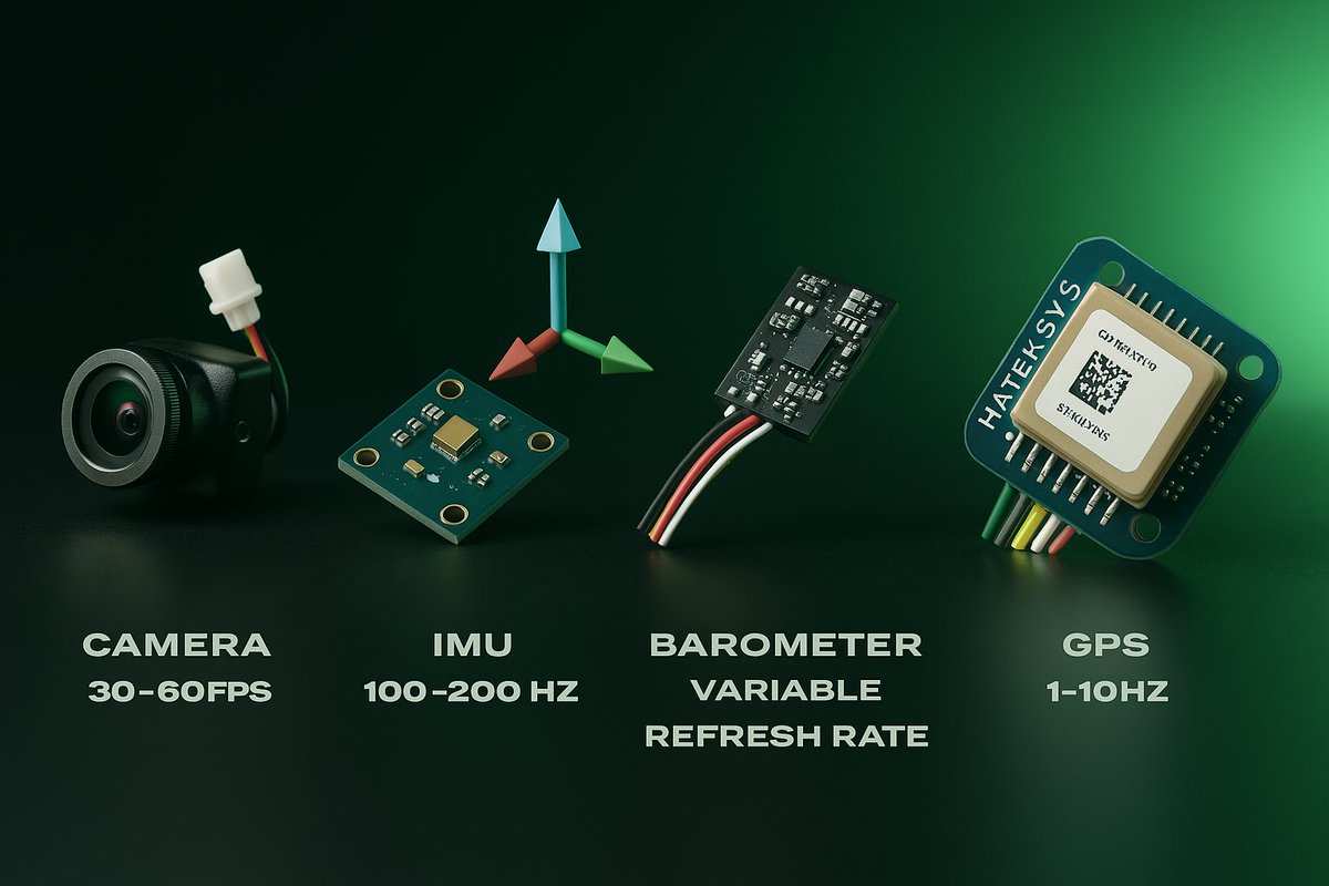
Camera, IMU, Barometer, GPS...

But how does that flow into decisions?

🧵 2 / 7 Image
Apr 9, 2025 7 tweets 3 min read
< Fundamentals of AI in Drones >

Dissecting the fundamentals of drone state estimation and sensor fusion in quadcopters

We're talking about sensors at high refresh rates, noise filtering with probabilistic filters, and predictive model controls that tie it all together

🧵 1/7 Image The Sensor Suite

Camera (@ ~30–60 FPS) - captures visual data for object detection, tracking, and navigation

IMU (@ ~100–200 Hz) - measures acceleration and rotational rates for fast attitude correction

GPS (@ ~1–10 Hz) - global positioning, often noisy and with respective tolerance

Barometer (variable refresh): assists in altitude estimation

These form the backbone of aerial state estimation

🧵 2/7Image