Summary: Nepal-India border issue
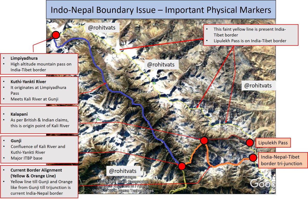
1) Nepal claims Kuti-Yankti River is MAIN Kali river
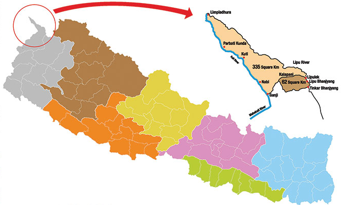
2) It originates at Limpiyadhura Pass on present Indo-Tibet border and flows till Gunji.
3) As per Nepal, all areas to east of this river (blue color in map) +
#NepalIndiaBorder
1) Nepal claims Kuti-Yankti River is MAIN Kali river
2) It originates at Limpiyadhura Pass on present Indo-Tibet border and flows till Gunji.
3) As per Nepal, all areas to east of this river (blue color in map) +
#NepalIndiaBorder
+
1816 Sugauli treaty should be part of Nepal.
4) Hence, Indian-Nepal border should be from Gunji to Limpiyadhura pass.
5) Entire area east of this, including Kalapani, India-Nepal-Tibet tri-junction, and Lipulekh Pass should be in Nepal.
6) Indian claim based on historical +
1816 Sugauli treaty should be part of Nepal.
4) Hence, Indian-Nepal border should be from Gunji to Limpiyadhura pass.
5) Entire area east of this, including Kalapani, India-Nepal-Tibet tri-junction, and Lipulekh Pass should be in Nepal.
6) Indian claim based on historical +
+
maps from 1879 and administrative records of Pithoragarh district from 1830 shows that Kalapani is starting point of Kali River. That is how river gets it name.
7) Kuti-Yankti is a tributary of Kali River but NOT the Kali River.
8) Kali river flows from Kalapani till Gunji
+
maps from 1879 and administrative records of Pithoragarh district from 1830 shows that Kalapani is starting point of Kali River. That is how river gets it name.
7) Kuti-Yankti is a tributary of Kali River but NOT the Kali River.
8) Kali river flows from Kalapani till Gunji
+
+
where it meets Kuti-Yankti River; from there, combined river, still known as Kali river, flows southwards.
9) From Kalapani downwards, India-Nepal boundary is divided along center of Kali river that is the present alignment of the boundary.
10) Lipulekh Pass is not considered +
where it meets Kuti-Yankti River; from there, combined river, still known as Kali river, flows southwards.
9) From Kalapani downwards, India-Nepal boundary is divided along center of Kali river that is the present alignment of the boundary.
10) Lipulekh Pass is not considered +
+
as 'east of Kali River' and hence, part of Nepal because it lies beyond origin of the river.
11) Sugauli Treaty refers to areas west and east of the river and hence, Lipulekh Pass does not come under the definition.
12) Administrative records from 1830 show area beyond +
as 'east of Kali River' and hence, part of Nepal because it lies beyond origin of the river.
11) Sugauli Treaty refers to areas west and east of the river and hence, Lipulekh Pass does not come under the definition.
12) Administrative records from 1830 show area beyond +
+
Kalapani and including Lipulekh pass being administered as part of Pithoragarh District.
Kalapani and including Lipulekh pass being administered as part of Pithoragarh District.
PART 2 -
Few points on historic basis of claims:
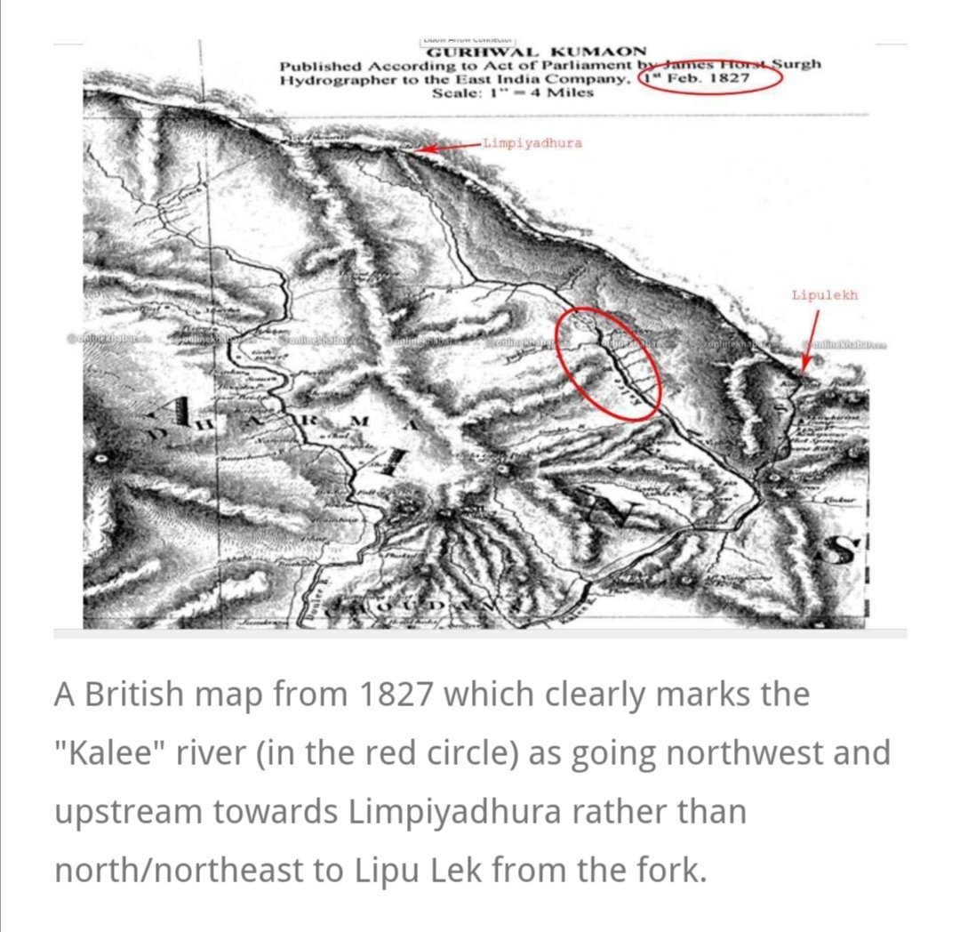
(1) Nepali claim - British maps of area from 1816 to 1856 which show Kuti-Yankti river as Kali River.
(2) India - Survey General of India 1879 map (below) which shows Kalapani as Indian territory. Present boundary+
Few points on historic basis of claims:
(1) Nepali claim - British maps of area from 1816 to 1856 which show Kuti-Yankti river as Kali River.
(2) India - Survey General of India 1879 map (below) which shows Kalapani as Indian territory. Present boundary+

+
boundary map is based on Survey General of India 1879 Map. Just for reference, see this 1924 British map of the area, its same as 1879. And shows Kalapani and Lipulekh Pass as parts of Indian territory.
boundary map is based on Survey General of India 1879 Map. Just for reference, see this 1924 British map of the area, its same as 1879. And shows Kalapani and Lipulekh Pass as parts of Indian territory.

This is the new official map released by the Nepali Government. The finer like area jutting out (marked under red circle) shows the area east of Limpiyadhura - Gunji axis which has been added to Nepali territory.

1827 Map of Garwhal Kumaon which shows Kuti-Yankti river marked as Kali River. This is one of the maps produced between 1816 and 1856 which forms basis of Nepali claim
Map courtesy: @deepak_ktm
Map courtesy: @deepak_ktm
Article by @KanakManiDixit and another author about basis of Nepali claims to Kalapani territory.
- Note the tone of article and mention about post-1990 'awakening' of people.
- BTW, don't miss this map in the article. See next tweet on its significance+
amp.scroll.in/article/962226…
- Note the tone of article and mention about post-1990 'awakening' of people.
- BTW, don't miss this map in the article. See next tweet on its significance+
amp.scroll.in/article/962226…
Video shared by @premzorbanian where a noted Nepali historian Professor Ramesh Kumar Dhungel explains the basis of historical Nepali claims. Brief comment about it in subsequent tweet+
+
He makes maps produced till 1856 as basis for Nepalese claims. And implies that India made changes which earlier Nepali administrations did not challenge. What he does not mention, for reasons best know to him, is that 1879 map of British India corresponds to present boundary.
He makes maps produced till 1856 as basis for Nepalese claims. And implies that India made changes which earlier Nepali administrations did not challenge. What he does not mention, for reasons best know to him, is that 1879 map of British India corresponds to present boundary.