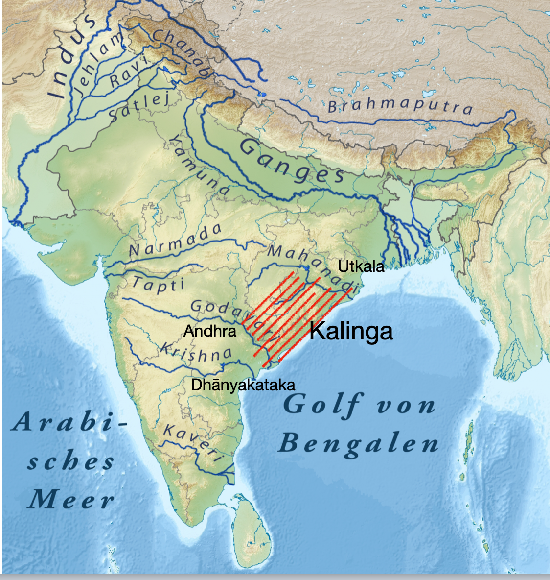
In this thread, I will discuss the history of the Kalinga region, that is stretched between the Godavari and the Mahanadi rivers.
Just as western civilizations refer to the whole of India by the name of the Sindhu civilization, our eastern neighbors refer to India as "Keling".
Just as western civilizations refer to the whole of India by the name of the Sindhu civilization, our eastern neighbors refer to India as "Keling".
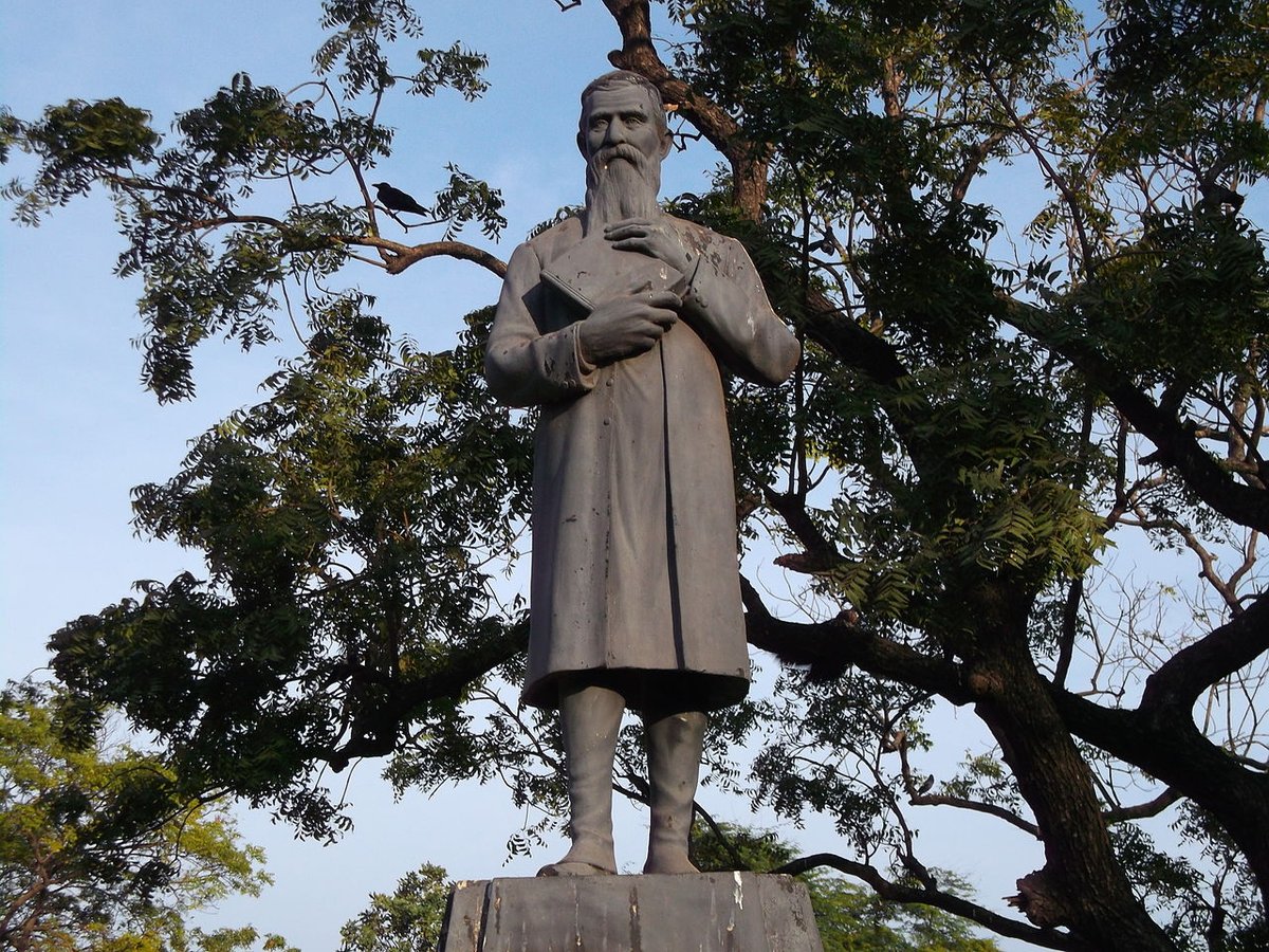
I will review some passages from the 1878 book by British surveyor Henry Morris "A descriptive and historical account of the Godavery district in the presidency of Madras". This district was the southern part of the Kalinga region.
This book is online: archive.org/details/descri…
This book is online: archive.org/details/descri…
The Kalinga region does not exist anymore on our maps, but it was one of the most illustrious regions in Indian history. The Kalinga people were mentioned amongst the oldest Purānas and Smritis, including the Mahābhārata.
Both the Telugu and Oriya people are their descendants.
Both the Telugu and Oriya people are their descendants.
Historically, the Kalinga region bordered the Utkala/Odhra region to the north of Mahānadi (whose name lives on in the Odisha state), the Andhra region to the west (which is tragi-comically not called Andhra anymore), and the Dhānyakataka region to the south of the Krishna river.
These ancient kingdoms roughly correspond to the 3 geographical divisions of the Telugu speaking people: the Andhra tribes lived in the current Telangana state, the Kalinga tribes in the coastal Andhra Pradesh, the Dhānyakatika kingdom aligned with the region of Rāyalaseema.
The Telangana region was also known historically as the Trikalinga, or equivalently the Mudukalinga (3 Kalingas, tri/mūdu being 3). It was referred to in the geographical treatise of Pliny the Younger as “Moccalingae”.
So “Kalinga” was an important influence on the interior too.
So “Kalinga” was an important influence on the interior too.
Some linguistic scholars have suggested that the name of the “Telugu” language itself derived as a corruption from the Trikalinga region. But I disputed that interpretation. The words Telangana and Trikalinga referring to the same region is a coincidence.
Pliny the younger wrote that the coastal part of the Moccalingae Trikalinga region is inhabited by the Calingae tribe. The ancient Greek visitor Megasthenes also referred to “Gangaridum Calingarum Regia” (the Gangetic Kalinga region) of which the “Calingae” was the coastal part.
Kalinga people were an ancient and powerful civilization, based on the coastal region, but who extended their influence into the hinterland by navigating the rivers upstream, either the Godāvari or the Gangā. They were a seafaring civilization who traded across the Bengal sea.
An ancient sea-faring civilization in the south east of India, that is navigating rivers upstream and civilizing the hinterland flows against the mainstream narrative in Indian history, which assumes that civilization flowed always from the north-west direction (Aryan myth).
But Kalinga is indeed cited in extremely ancient western scholarship. Here is the corresponding passages from Pliny the Younger, where he discusses the Moccalingae, who he says are a sub-group of the "Brachmanae" (Brāhmanas) which is a generic name for all the tribes of India.

The specific geography of the Kalinga region was also cited by Pliny the Younger, and hotly debated by the early Indologists.
In these ancient Roman texts, the name "Ganges" was most likely also used for the Godāvari river, which is considered as the "Southern Ganges" in India.
In these ancient Roman texts, the name "Ganges" was most likely also used for the Godāvari river, which is considered as the "Southern Ganges" in India.
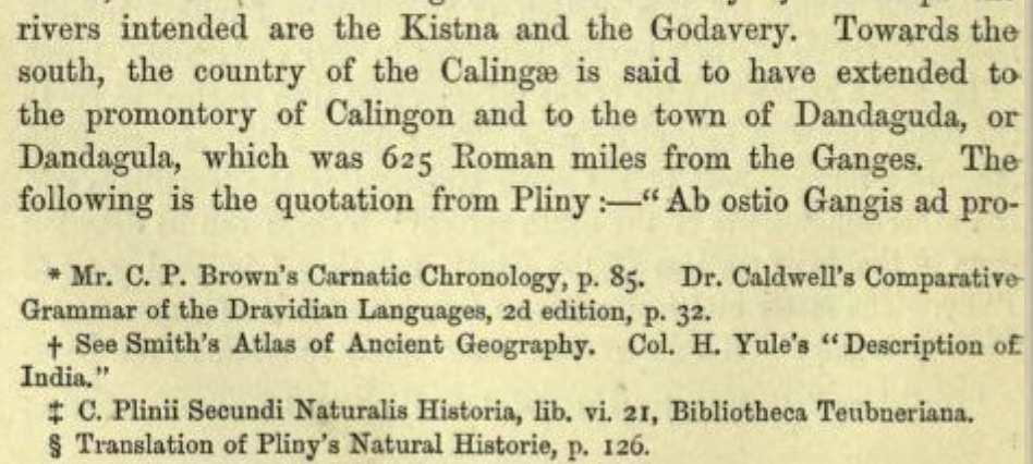

The identification of the port city of "Calingon" and the economic capital of "Dandaguda" or "Dandagula" is of extreme importance in understanding the Kalinga civilization. The current scholarship seems to identify this in the Śrīkākulam district.
ccbs.ntu.edu.tw/FULLTEXT/JR-EN…
ccbs.ntu.edu.tw/FULLTEXT/JR-EN…
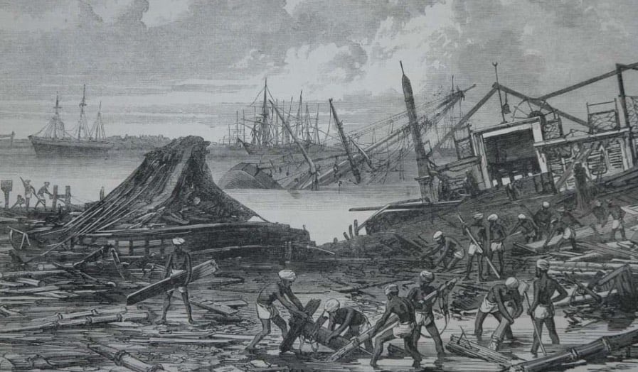
I want to dispute this identification. From my understanding, the observation of Mr. Ferguson was correct. The famous ancient port of “Calingon” is Koringa, and more accurately, the desolate island off the Kakinada city, now known by an anglicized name “Hope Island”.
The distance of 625 Roman miles (~1480 km) from the mouth of the Ganges to Coringa tallies well. Although the current generation has no idea about it, the port of Coringa was one of the largest and the busiest in India until mid 1800s, until it was utterly destroyed by a cyclone.
Indeed, the very word “cyclone” was coined by Henry Piddington to describe this monstrous storm that hit the Coringa port in 1839, which killed 20000 people and which caused waves 12 meters (40 feet) high. It was one of the worst natural disasters ever.
historycollection.com/12-historys-re…
historycollection.com/12-historys-re…
Let us say we identify the ancient “Calingon” with the destroyed port on “Hope Island”. Now, where is the economic capital of Dandaguda/Dandagula? I think its identification with Rajahmundry was wrong.
I think it is in a village called “Denduluru”, near the modern town of Eluru.
I think it is in a village called “Denduluru”, near the modern town of Eluru.
Why do I identify this rich ancient town with a nondescript village? Extraordinary archeological record, described by Henry Morris himself. I don't know if any of these mounds were investigated further. I dread that this evidence is lost by neglect/worse. It must be investigated.

The association of an ancient Vigneśwara temple with a "Dantapura" or a location with a sacred tooth makes perfect sense. Vināyaka/Vigneśwara is considered "Ekadanta". This "tooth", whether in the Buddhist or the Hindu sense, is an astronomical reference to calibrate a calendar.
In Hinduism, the same sacred regions are viewed by different religious sects differently. This is the case for Buddhism as well. This is why a Śiva temple was built in Sarnath. A Vināyaka temple can likewise be in "Dantapura", although the colonial scholarship was blind to it.
Let us consider the word "Kalinga" itself. Does it have any specific etymology? In my own search, I saw nothing on this regard. But I don't think this name is arbitrary.
In my opinion, it derives from "kha-linga", where "kha" is the cosmos. Equivalently, it is "ākāśa-linga".
In my opinion, it derives from "kha-linga", where "kha" is the cosmos. Equivalently, it is "ākāśa-linga".
What exactly is this "Linga" (sign) in the cosmos? I think this refers to an ancient observation of the star Sirius, known as Mrigavyadha (the hunter of the deer).
These ancient astronomical models condensed into the religious praxis of Śaivisim.
These ancient astronomical models condensed into the religious praxis of Śaivisim.
Indeed, the Kalinga region is teeming with ancient Śaivaite pilgrimate places of very high importance. Perhaps the most important is the temple at Drākshārāma, derived from "Dakshārāma", or the garden (Ārāma) of Daksha, who was identified as the Prajāpati (progenitor of mankind).
Extraordinary ruins of Śaivaite temples were present in the village of Biccavōlu (originally known as Birudānkitapuram) - the ancient capital of the Chālukya empire before it shifted to Rajahmundry. The Vaishnavaite religion got popular much later than the older Śaivaite praxis.

This Godavari delta region is teeming with ancient archeological remains, which were scarcely investigated, despite many attestations from the Indian literary record.
The Sapta-Godāvaram actually mimcs the Sapta Sindhu of the north west of India, with its seven Rishis.
The Sapta-Godāvaram actually mimcs the Sapta Sindhu of the north west of India, with its seven Rishis.
Amongst the various Indian tribes, Kalinga were a highly civilized tribe with agriculture and seafaring, who developed original astronomical models through a record of observation by Rishis.
For this reason, they spread westwards and influenced the culture of the hinterland.
For this reason, they spread westwards and influenced the culture of the hinterland.
Trikalinga arose as a natural extension of Kalinga, with 3 different Śaivaite places of pilgrimage. These temples are sacred even today: Drākshārama on the Godāvari delta (previously mentioned), Śrīśailam and Mukteśwaram, where Krishna and Godāvari enter the plains respectively.
Now let us consider the word "Āndhra", the other ancient tribe of this region. They were spread along the interior of the Deccan plateau, which was a thick forest (and remains so even today at certain places). This word is likely derived from "Andhakāranya" (pitch dark forest).
The Telugu language and culture arose as a confluence of these ancient Āndhra and Kalinga tribes. Of the two, the Kalinga tribe was undoubtedly the more civilized. This tribe spoke a Prākrit language, and also greatly contributed to the development of the sacred Sanskrit speech.
I have spent enough time debunking the bullshit Dravidian theory of languages, but Kalinga civilization is the very kryptonite for this nonsensical theory. Sanskrit culture arose and flew north-west from the Godāvari delta region, where it’s influence is the strongest and oldest.
What was the source of economic strength of the Kalinga civilization? Trade, especially by the sea and by the rivers. In ancient times, the waterways were far more accessible to the transport of goods than the inland roads. This is especially true before motorized transport.
The agricultural economy of the Kalinga people was most likely based on the cultivation of rice. In India, the earliest evidence for the cultivation of rice was in the Gangetic plain. I think the upstream regions of Godāvari and Mahānadi were irrigated not much later to that.
The cultivation of rice particularly demands extensive irrigation systems. This irrigation is the root of the Āryan culture. The word “Āryam” can be etymologically traced to irrigation. The Kalinga civilization was definitely an “Ārya” civilization.
But the spread of irrigation networks to the Godāvari happened at a later time. Earlier, they were limited to above the Vindhyas, as recollected in the Manusmriti. Thus, within the Kalinga civilization, Mahānadi was likely cultivated earlier to Godāvari.
The cultivation of rice requires not only extensive irrigation, but also astronomical observations to track the seasons. These astronomical models are also necessary for navigation by the sea. The Kalinga civilization mastered this, just like the Saraswati civilization earlier.
Where would a rich seafaring civilization establish its port cities? This is an important criterion to determine the location of the ancient “Calingon”.
Almost all civilizations established port cities at the mouth of great rivers, so the wares can be transported further inland.
Almost all civilizations established port cities at the mouth of great rivers, so the wares can be transported further inland.
In northern India, the great port cities of Tāmralipti on the Gangā, and Dholavira on the Saraswati (perhaps the ancient Dwarka) have enabled the transport of trade goods inland to the population centres along the River banks. The same must have happened in the Kalinga region.
There is the port of Paradwīpa (Pardeep) at the mouth of Mahānadi, which is undoubtedly an important port since ancient times. Similarly, at the mouth of Godāvari is the ancient port of Coringa. Both the ports might have slightly shifted location due to silting on the river beds.
The strategic location of the mouth of Godāvari was the reason why one of the earliest colonial “factories” (regiments of soldiers) were established here. The French established their factory at Yanam, the Dutch at Jagan athapuram and the English at Kakinada, all around Koringa.
As monsoon fed rivers, both the Godāvari and the Mahānadi transport an enormous amount of silt during the monsoon season. The waters turn reddish brown with mud, which gets deposited on the ports, requiring extend desilting and dredging, as the colonial administrators realized.
Prior to colonial times, the port cities were likely to be on mud islands deposited by centuries of silt carried by the rivers. On the sea side of such islands, there will be less silt accumulation. The Koringa port was exactly in such a location, until it was utterly destroyed.
Typical of British colonial historians, Henry Morris ignores all the references in the native tradition (Daksha Prajāpati and so on) and imposed an artificial Dravidian theory on the settlement of the Godāvari district. He calls these ancient people as “civilized but idolatrous”.
Following the racist theories of Bishop Caldwell, whose work he cites in this book, Henry Morris calls “Dravidians” of the Godāvari district as idolatrous folks, in contrast to the “Heliolatry” (sun worship) of the Āryan invaders, who he says have further civilized these lands.
The travelogues of the Chinese pilgrim Hiouen Tsang (Xuan Zhang) give additional information about the Kalinga region. He wrote that, during his time - probably 7th century AD, southern India was divided into 9 large kingdoms, 3 of which are Kalinga, Āndhra and Dhānyakatika.


Hiouen Tsang visited the Kalinga capital, which he said was 250 miles south west of Ganjam. He mentioned Āndhra was to the west, and that Dhanakacheka (Dhānyakatika) was to the south-west of Kalinga.
In circuit, Kalinga was 830 miles, Andhra 500 miles & Dhanakacheka 1000 miles.
In circuit, Kalinga was 830 miles, Andhra 500 miles & Dhanakacheka 1000 miles.
Instead of going from Kalinga to Andhra, Hiouen Tsang went to the kingdom of Kosala (to the north of Mahānadi) and then entered Andhra through an interior route. Henry Morris reasons this was due to impenetrable forests at Pāpikondalu. I think it could also be a pilgrimage route.
Dhānyakatika region has historically been part of the Karnataka kingdoms. It was later also a central part of the Vijayanagara empire. This region had several centuries of warfare with the Kalinga, over the extremely fertile doab of Vengi, between the Godavari and Krishna rivers.
In the racist treatise of Bishop Caldwell about "Dravidian Languages", Hiouen Tsang is credited as the first person to have historically mentioned the distinctiveness of Andhra/Telugu language. Caldwell also says, rather ridiculously, that Kalingas were a remote inferior culture.


Caldwell himself says earlier that Kalingas were a rich trading civilization. Then how come they were remote and inferior!? The reasons Kalingas were not mentioned separately by Sanskrit writers was because they themselves were "Ārya", highly conversant in the Sanskrit language.

This stupid racist theory of Āryan and Dravidian races ties itself into very ridiculous knots. At one point, Kalingas were a superior sea-faring civilization. At another point, they were remote and inferior.
It is amazing that such nonsense is tolerated till this day!
It is amazing that such nonsense is tolerated till this day!
There is a simple explanation to the Kalinga civilization and their highly Sanskritized practices: Āryan is not a race (neither is Dravidian). The Āryan race is an absurd bullshit imagined by Europeans. In reality, "Ārya" means cultured people practicing "irrigation" and farming.
The name "Kalinga" was retained by several kingdoms, including the one visited by Hiouen Tsang. There were also many with capitals on the Mahānadi region. They even established pan-Indian empires, like under Kharavela. Thus the memory of the ancient Kalinga Janapada was retained.
Although "Kalinga" doesn't exist anymore as a geopolitical entity, and its history poses serious inconvenience to the racist divisions of people into Āryan and Dravidians, the influence of Kalinga remains present all over Indian culture, and especially in Odiya and Telugu people.
I will conclude this thread by this fetching description of the Pāpikondalu region, where the Gōdāvari river enters the plains of the Kalinga Janapada, written by none other than Henry Morris himself.
I also post a photo taken by myself at this charming location. (End of thread)
I also post a photo taken by myself at this charming location. (End of thread)