THREAD: Restless and Thankful - my @BBCScotlandNews feature about #Scotland's infamous road through 'a mountain in torment' 

The A83 runs for almost 100 miles from Loch Lomond to Campbeltown, at the foot of the Kintyre peninsula. But there is one section, near the Rest and Be Thankful, which has become infamous for landslips, closures and long diversions.
James MacDonald and his family watched in terror as 30,000 tonnes of rock and mud churned its way down the side of the mountain towards them.
He later described the landslide as “boiling with gyrations and spurts of water above, with detonations like a continued salute of cannon, sometimes with the confusion of a giant and indescribable roar - the roar of a mountain in torment.”

The A83 road near Arrochar became impassable as the debris hurtled down, and flooded the Glen Croe valley below.
But this landslide is not the one that has kept the mountain road closed since 5 August; and nor was it known as the A83.
But this landslide is not the one that has kept the mountain road closed since 5 August; and nor was it known as the A83.
In fact MacDonald’s testimony is from 1913.
“These landslips have always happened here,” says Mary Haggarty. “They’ve just become something that we’ve learned to live with”.
Mary, who helps run the local heritage group, has lived in Arrochar since her birth in 1942.
“These landslips have always happened here,” says Mary Haggarty. “They’ve just become something that we’ve learned to live with”.
Mary, who helps run the local heritage group, has lived in Arrochar since her birth in 1942.

An old school log from February 1913 states matter-of-factly that "attendance [is] reduced this week owing to a landslip having occurred rendering the road impassable for those of the scholars who had to come by it".
"It wasn't such a big deal then - people just got out with shovels and cleared the roads themselves," Mary says.
"And people would just use steamer ships to get to where they wanted to go."
"And people would just use steamer ships to get to where they wanted to go."
But times, it seems, have changed.
“There’s heavier traffic now, and life moves faster with people in a rush to get to places,” she recalls.
The A83 provides a vital link to towns such as Inverary, Lochgilphead and the Kintyre peninsula, and is used by 4,000 vehicles a day.
“There’s heavier traffic now, and life moves faster with people in a rush to get to places,” she recalls.
The A83 provides a vital link to towns such as Inverary, Lochgilphead and the Kintyre peninsula, and is used by 4,000 vehicles a day.
Mary's great-grandfather John Bell (left) was a roadman who was employed to maintain the track through Glen Croe as it snaked its way north to Inverary.
He worked the road in 1913 when it was hit by a landslide, and in 1926 another landslip almost carried away his house.
He worked the road in 1913 when it was hit by a landslide, and in 1926 another landslip almost carried away his house.

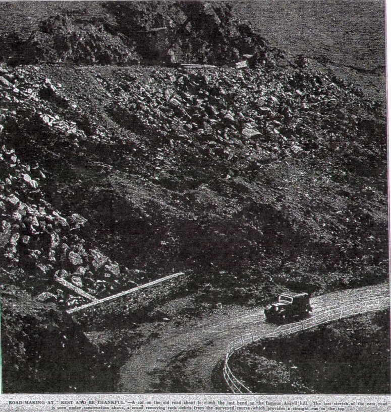
Of course back then it wasn't called the A83. For centuries the pass has been affectionately known as The Rest and Be Thankful, or simply The Rest.

The climb out of Glen Croe is so long and steep that it was traditional for travellers and drovers to rest at the top, and be thankful for having made the highest point (803 feet).

What had been just a valley track for centuries, started to become a road proper in 1743 in response to the Jacobite uprisings.
General George Wade recommended the construction of over 40 miles of road which would link a series of military forts.
General George Wade recommended the construction of over 40 miles of road which would link a series of military forts.
By the 1920s the track was in disrepair, and a London Times editorial lamented its maintenance as “an impossible burden” for the taxpayers of the Highland counties.
Construction on a new road then began in 1937 at a cost of £100,000 - that’s nearly £7 million at today’s prices.
Construction on a new road then began in 1937 at a cost of £100,000 - that’s nearly £7 million at today’s prices.


Construction continued despite the onset of World War Two and the new road - sitting 150m to the east of the old military road - was completed in 1941.


But while travellers may be thankful to reach the top, the slope above the pass has been restless.
Dr Andrew Finlayson - a geomorphologist from the British Geological Survey - attributes this to the steep slopes, the sediment on the hillsides, and spells of high rainfall.
Dr Andrew Finlayson - a geomorphologist from the British Geological Survey - attributes this to the steep slopes, the sediment on the hillsides, and spells of high rainfall.

"The glaciers that once flowed here contributed to these conditions by eroding steeper slopes + piling up sediment high on the hillsides," he says.
"When the glaciers melted the sediment was no longer supported by the ice margins, so in places it's susceptible to landsliding."
"When the glaciers melted the sediment was no longer supported by the ice margins, so in places it's susceptible to landsliding."
Most of the "debris flow" in the area took place in the first few centuries after the last glaciers melted - about 11,500 years ago.
"The landscape now is much more stable than it was then, but we still see this episodic behaviour driven by rainfall events," says Dr Finlayson.
"The landscape now is much more stable than it was then, but we still see this episodic behaviour driven by rainfall events," says Dr Finlayson.

On sunny days a series of small valleys, caused by previous landslides, cast shadows accentuating these scars across the south-western slope of Beinn Luibhean.
VIDEO:
VIDEO:
It is here, near the base of the 858m high mountain, where The Rest has been carved into its side.
In recent years the road it has become infamous for the number of closures caused by landslips.
In recent years the road it has become infamous for the number of closures caused by landslips.
It was closed for 17 days in October 2007, and since then nine more landslides have left the road impassable.
It was blocked in September 2009, December 2011, August 2012, October 2013, October 2014, October 2015, October 2018 - and twice this year.
It was blocked in September 2009, December 2011, August 2012, October 2013, October 2014, October 2015, October 2018 - and twice this year.
1,000 tonnes of debris closed the road in January, + earlier this month was blocked by 6,000 tonnes of debris - including "car-sized boulders" - after heavy rain.
When the The Rest is closed, the Old Military Road is still used to convoy vehicles up the pass in a single file.
When the The Rest is closed, the Old Military Road is still used to convoy vehicles up the pass in a single file.

Transport Scotland has invested more than £13.6m in landslide measures in the area. This work is estimated to have helped keep The Rest open for 48 days when it would otherwise have closed.
This is just part of the £82m invested in the wider maintenance of the A83 since 2007.
The work includes four "catchpits", which have now been completed, with a total capacity of almost 15,000 tonnes.
The work includes four "catchpits", which have now been completed, with a total capacity of almost 15,000 tonnes.

Mary Haggarty says any closures of the road now have a greater economic impact than they did when she was growing up - simply because Arrochar is now so reliant on tourism.
The losses associated with the 2007 landslide were estimated to be about £80,000 per day - which comes to £1.2m over the 15 day closure.
The road has already been closed for more than three weeks as a result of the landslide on 5 August this year.
The road has already been closed for more than three weeks as a result of the landslide on 5 August this year.

The Scottish government has asked Transport Scotland to speed up its work on providing a long-term solution to dealing with the problem.
Jim Young, a former chair of the Institution of Civil Engineers Scotland, says environmental shifts are now an additional challenge.
Jim Young, a former chair of the Institution of Civil Engineers Scotland, says environmental shifts are now an additional challenge.

"We know that in whatever form it may be - whether it's heavier rainstorms, changing temperature - climate change is upon us and it will impact on various bits of our infrastructure," he says.
"Roads are the obvious one. Whatever happens, we've got to look at the whole infrastructure systems that support our society."