USGS Earthquakes Profile picture
Sep 2, 2020 9 tweets 4 min read Read on X
Here was this week’s #MindteaserMonday poll. Are you ready for all the answers to be revealed? 😸
Magnitude is the physical size of the earthquake!

Multiply the length of the fault segment that slid by the width by how far one side of the fault slid past the other side … and you’ll get a really big number. 😸 Image
How big is “really big”?

1989 M6.9 Loma Prieta ruptured 25 miles w/ ~6 ft of slip. That’s 30 billion cubic feet of earthquake.

But the 1906 M7.9 San Francisco earthquake ruptured 300 miles of the San Andreas w/ 2-32 ft of slip. 1 trillion cubic feet of earthquake!

*width~7 mi Image
Billions and trillions of cubic feet: that’s a lot of zeroes. So we use a log scale to convert those really big numbers into a handy dandy magnitude that can be easily compared across those huge numbers.
FUN FACT 🔥🔥🔥🔥
The scientific paper that coined the phrase moment magnitude scale was written by Hiroo Kanamori and @USGS ‘s Tom Hanks. I bet you didn’t know that besides his other talents Tom Hanks is also a famous seismologist. Image
Let’s talk about the other poll options…
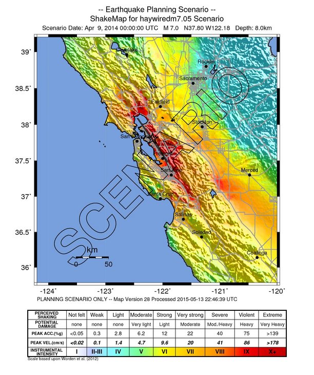
Does magnitude tell you the amount of shaking? Not by itself. Other things matter too, like how close you are. Shaking in Vallejo, CA from the 2014 M6 South Napa earthquake was probably about as strong as in the bigger 1906 M7.9 quake because Vallejo is much closer to Napa. ImageImage
Does magnitude tell you how large a region will be shaken? Not by itself. For example, pound-for-pound, earthquakes in the central and eastern U.S. shake a larger area than left coast quakes. Compare how far away people felt the 2011 M5.8 Mineral quake in VA to a M6 in CA. Image
This is one of many reasons we need people to fill out Did You Feel It? reports when you feel an earthquake AND when you don’t feel an earthquake. Seriously, let us know when you don’t feel a quake. It really helps us to know where there isn’t shaking.

earthquake.usgs.gov/data/dyfi/ Image

• • •

Missing some Tweet in this thread? You can try to force a refresh
 

Keep Current with USGS Earthquakes

USGS Earthquakes Profile picture

Stay in touch and get notified when new unrolls are available from this author!

Read all threads

This Thread may be Removed Anytime!

PDF

Twitter may remove this content at anytime! Save it as PDF for later use!

Try unrolling a thread yourself!

how to unroll video
  1. Follow @ThreadReaderApp to mention us!

  2. From a Twitter thread mention us with a keyword "unroll"
@threadreaderapp unroll

Practice here first or read more on our help page!

More from @USGS_Quakes

Jul 19, 2022
Many folks (and their kids) asked why earthquakes happen in the central and eastern U.S., far away from plate boundaries. There are many reasons! #QuakeQuestions🧵
First, the plate boundary is a lot wider than you might think. In California, most motion between the Pacific and North America plates happens on the San Andreas fault. But that plate motion is stretching the crust (and causing earthquakes) as far east as the Colorado Plateau.
In the past, the tectonic plates were very different than they are today. Remnants of ancient plates and past mountain building have left faults throughout the U.S. on which earthquakes can occur to relieve stress. And there are plenty of non-tectonic stress sources. Map of North America showing locations of faults within the
Read 6 tweets
Jul 14, 2022
Ok Oregon, you asked so we’re answering your #QuakeQuestions from Monday. If you’re not already following @OregonOEM or @PNSN1 be sure to do so as they are your go-to's for local info about emergencies and earthquakes in Oregon and the Pacific Northwest.
What’s the deal with earthquakes in Oregon? As many of you mentioned in Monday's #QuakeQuestions post, this region of the U.S. is capable of hosting very large (M9!) earthquakes along the #Cascadia subduction zone where the Pacific plate slides beneath the North American plate. Cascadia megathrust fault map. Topo-bathymetric map of the CSubduction zone schematic. Schematic cross-section of the ac
How do we know such large earthquakes are possible? Check out this thread to learn more about the 1700 M9 Cascadia earthquake – the largest known earthquake to have occurred in the conterminous U.S.
Read 10 tweets
Jan 26, 2022
Today marks the 322nd anniversary of the 1700 AD Cascadia earthquake – the largest known earthquake to have occurred in the "lower 48" United States.
This (estimated) magnitude 8-9 earthquake ruptured along the 1300-km-long Cascadia subduction zone which sits off the coast of northern California, Oregon and Washington. Topo-bathymetric map of the Cascadia subduction zone. Cascad
Here, the eastern margins and dense oceanic crust of the Gorda and Juan De Fuca plates meet their demise as they subduct beneath the lighter continental crust of the north American plate. Cross-section or side view schematic of the Cascadia Subduct
Read 9 tweets
Oct 14, 2021
An intro to earthquake prediction 🧵🧵

Individual earthquakes can’t be usefully predicted. It’s not because they’re mystical or magical. Earthquakes obey very simple physics. The issue is that earthquakes occur deep underground.
In California, earthquakes typically rupture faults at depths of ~10 mi (~15 km). We have no eyes on the fault at depth: can’t see what materials are in the fault, where they’re lubricated by fluids, how close any point is to failure, or how large an area might fail.
If you can’t see the fault at depth, you can’t directly predict what the fault will do. Instead some researchers try to correlate large quakes with other things like having small quakes – or maybe not having small quakes? It’s not clear that there is any predictive power here.
Read 6 tweets
Sep 1, 2021
**New publication alert**
What could happen to communication networks if a large #earthquake happened in the SF Bay Area, along the Hayward fault? 📞📱☎️📳
The new #HayWiredScenario chapter on telecommunications & ICT asks “what if” & explains why we should #TextNotTalk Map depicting SCENARIO distribution of shaking severity in a
Using proxies including power shutoffs, wildfires, & other earthquakes to model what happens to #telecom in a #HayWiredScenario, they found vulnerabilities in power service, cell sites on buildings and poles, and data lines crossing the fault surface rupture. Map of the San Francisco Bay region, California, showing fib
Contributing to the issue are multiple competitive service providers in a largely unregulated industry, convergence of analog and digital systems, layers of hardware and software functionality, dependence on electric power, and the rapid evolution of technology. Photo showing co-located electrical and telecom infrastructuThese photos show repair dependence between telecommunicatio
Read 9 tweets
Jul 9, 2021
Yesterday afternoon, just before 4 pm local time, a M6.0 earthquake occurred at the California-Nevada border. Let’s dive deeper into some of the regional geology on this edition of #FaultFriday.
East of the San Andreas fault, the plate boundary doesn’t stop moving. Even though ~70% of the relative motion of the Pacific-North American plates occurs within the San Andreas fault system, that leaves ~30% to be accommodated elsewhere.
Moving east from the San Andreas fault from ~San Francisco, more plate motion is accommodated at the eastern rangefront of the Sierra Nevada. If you’ve ever wondered why the Sierra look even more impressive from the east than the west, enter: active tectonics.
Read 13 tweets

Did Thread Reader help you today?

Support us! We are indie developers!


This site is made by just two indie developers on a laptop doing marketing, support and development! Read more about the story.

Become a Premium Member ($3/month or $30/year) and get exclusive features!

Become Premium

Don't want to be a Premium member but still want to support us?

Make a small donation by buying us coffee ($5) or help with server cost ($10)

Donate via Paypal

Or Donate anonymously using crypto!

Ethereum

0xfe58350B80634f60Fa6Dc149a72b4DFbc17D341E copy

Bitcoin

3ATGMxNzCUFzxpMCHL5sWSt4DVtS8UqXpi copy

Thank you for your support!

Follow Us!

:(