USGS Earthquakes Profile picture
The magnitude of USGS knowledge, strong. Our intensity, felt globally. Follow for EQ science, news, events & answers. Not staffed 24/7. EQ alert bot: @USGSted
Sherry Minson Profile picture 1 subscribed
Jul 19, 2022 6 tweets 4 min read
Many folks (and their kids) asked why earthquakes happen in the central and eastern U.S., far away from plate boundaries. There are many reasons! #QuakeQuestions🧵 First, the plate boundary is a lot wider than you might think. In California, most motion between the Pacific and North America plates happens on the San Andreas fault. But that plate motion is stretching the crust (and causing earthquakes) as far east as the Colorado Plateau.
Jul 14, 2022 10 tweets 9 min read
Ok Oregon, you asked so we’re answering your #QuakeQuestions from Monday. If you’re not already following @OregonOEM or @PNSN1 be sure to do so as they are your go-to's for local info about emergencies and earthquakes in Oregon and the Pacific Northwest. What’s the deal with earthquakes in Oregon? As many of you mentioned in Monday's #QuakeQuestions post, this region of the U.S. is capable of hosting very large (M9!) earthquakes along the #Cascadia subduction zone where the Pacific plate slides beneath the North American plate. Cascadia megathrust fault map. Topo-bathymetric map of the CSubduction zone schematic. Schematic cross-section of the ac
Jan 26, 2022 9 tweets 3 min read
Today marks the 322nd anniversary of the 1700 AD Cascadia earthquake – the largest known earthquake to have occurred in the "lower 48" United States. This (estimated) magnitude 8-9 earthquake ruptured along the 1300-km-long Cascadia subduction zone which sits off the coast of northern California, Oregon and Washington. Topo-bathymetric map of the Cascadia subduction zone. Cascad
Oct 14, 2021 6 tweets 3 min read
An intro to earthquake prediction 🧵🧵

Individual earthquakes can’t be usefully predicted. It’s not because they’re mystical or magical. Earthquakes obey very simple physics. The issue is that earthquakes occur deep underground. In California, earthquakes typically rupture faults at depths of ~10 mi (~15 km). We have no eyes on the fault at depth: can’t see what materials are in the fault, where they’re lubricated by fluids, how close any point is to failure, or how large an area might fail.
Sep 1, 2021 9 tweets 6 min read
**New publication alert**
What could happen to communication networks if a large #earthquake happened in the SF Bay Area, along the Hayward fault? 📞📱☎️📳
The new #HayWiredScenario chapter on telecommunications & ICT asks “what if” & explains why we should #TextNotTalk Map depicting SCENARIO distribution of shaking severity in a Using proxies including power shutoffs, wildfires, & other earthquakes to model what happens to #telecom in a #HayWiredScenario, they found vulnerabilities in power service, cell sites on buildings and poles, and data lines crossing the fault surface rupture. Map of the San Francisco Bay region, California, showing fib
Jul 9, 2021 13 tweets 3 min read
Yesterday afternoon, just before 4 pm local time, a M6.0 earthquake occurred at the California-Nevada border. Let’s dive deeper into some of the regional geology on this edition of #FaultFriday. East of the San Andreas fault, the plate boundary doesn’t stop moving. Even though ~70% of the relative motion of the Pacific-North American plates occurs within the San Andreas fault system, that leaves ~30% to be accommodated elsewhere.
Jul 9, 2021 5 tweets 4 min read
Update on the M 6.0 #earthquake that occurred at 3:29 pm Pacific Time July 8, in Antelope Valley, California, near the Nevada border. #califearthquake You can find up-to-date details about the earthquake here: earthquake.usgs.gov/earthquakes/ev… Shaking of intensities up to VII was reported nearest the epicenter. The quake was felt all the way to the Pacific Coast and throughout CA’s Central Valley as well as strongly in Reno and Carson City.
Did You Feel It? Report here:
earthquake.usgs.gov/earthquakes/ev…
Jul 6, 2021 7 tweets 3 min read
An M5.2 earthquake occurred 12 km (7.5 mi) NNW of Kukuihaele, Hawaii yesterday at 1:34 PM local time. So far >1,300 people have reported feeling shaking. If you felt this quake (or not!), click the link below to tell us about your experience. For more on EQs in Hawaii, see 🧵👇. Thousands of earthquakes occur every year in the State of Hawaii most of which are small & caused by eruptive processes w/in the active volcanoes on & around the Island of Hawaii, especially in the southern districts where the Kilauea, Mauna Loa & Loihi volcanoes are most active. Image
Mar 4, 2021 5 tweets 3 min read
Two large earthquakes have occurred beneath the southwest Pacific today. The earlier M7.3 was strongly felt across much of New Zealand. The more recent M7.4 occurred ~4 hr later, ~900 km away. Given the large distance between them, the events are probably not directly related. 🧵 map showing earthquake epicenters for March 5 in the south P 
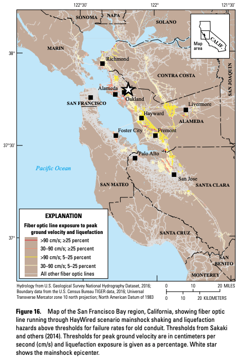
The @USGS-determined focal mechanism and origin location for the earlier M7.3 near New Zealand suggest that the earthquake resulted from complex faulting within the subducting Pacific Plate. earthquake.usgs.gov/earthquakes/ev…
Oct 2, 2020 6 tweets 2 min read
Yes, swarms aside, it is still Friday, and on this channel, that means #FaultFriday. To learn more about the area around the Westmorland swarm, let’s look at the Imperial fault of southern California today. The Imperial fault is a right-lateral strike-slip fault (ow.ly/gKEq50BIfDq) that runs south of the Salton Sea, across the US-Mexico border, and into Mexico. The Imperial fault had two significant earthquakes in the 20th century, a M6.9 in 1940 and a M6.5 in 1979. Map showing Imperial fault and Westmorland Swarm in southern
Oct 1, 2020 7 tweets 3 min read
An #earthquake swarm has kicked off southwest of the #SaltonSea today, producing 240 earthquakes as of 8pm Pacific. The largest earlier this evening was M4.9.
So what does this mean? We’ve put together some scenarios to explain what could happen next. usgs.gov/center-news/ea… 
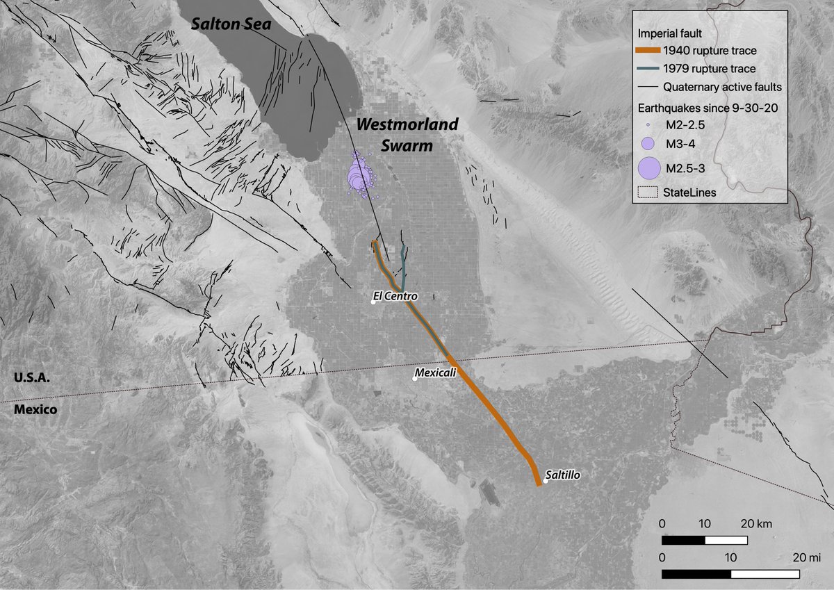
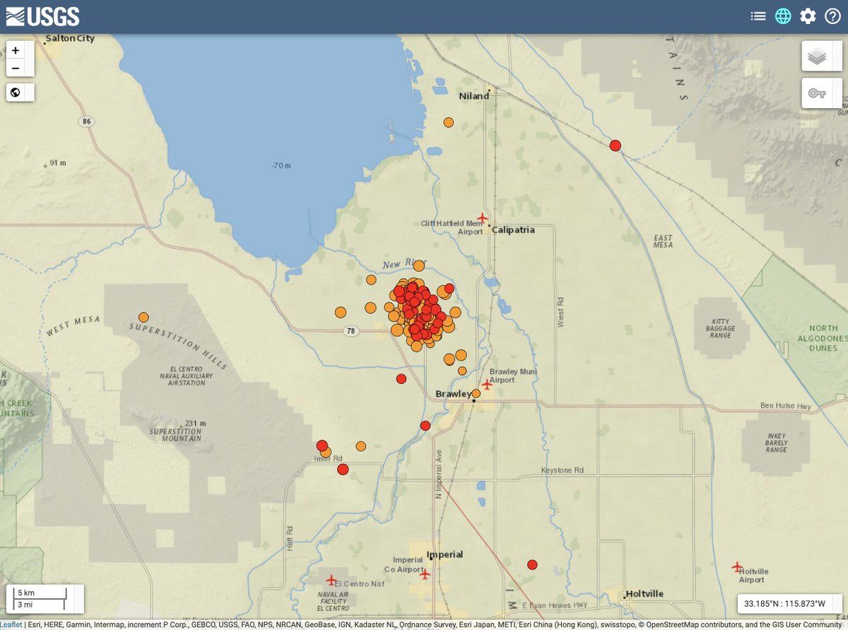
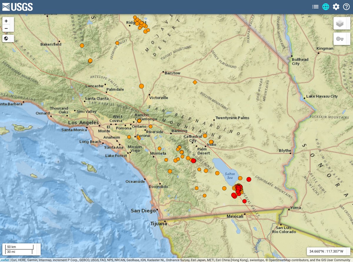
The most likely scenario is that the rate of earthquakes in the swarm will decrease over the next 7 days. Some additional moderate-sized earthquakes (M4.5 to 5.4) may occur. Smaller magnitude earthquakes (M3.0+) may be felt by people close to the epicenters.
Sep 30, 2020 6 tweets 4 min read
What do subduction zones do? They do everything! They make earthquakes and volcanos and tsunamis. 😸 When one plate slides under another, it sinks into the hotter parts of the Earth and starts a melting process. The melt floats up creating a line of volcanoes (called a chain or arc) like the Cascades volcanoes in California, Oregon, and Washington. Oceanic-continental converg...Map of Cascades volcanosMount St. Helens (left) and...
Sep 25, 2020 5 tweets 2 min read
Yes, check your calendars—today is Friday! We are happy to bring you a recurring weekly treat of #FaultFriday, where we introduce you to a different fault across the country. For this #FaultFriday, let's visit Wyoming and check out the normal Teton fault. @WyGeoSurvey recently published a gorgeous new map of the Teton fault below: Fault map showing topograph...
Sep 21, 2020 7 tweets 2 min read
Ever wonder what #EarthquakeHazard looks like for the entire US? The @USGS’s National Seismic Hazard Map (NSHM) defines the potential for earthquake ground shaking for various probability levels across the country. Image 
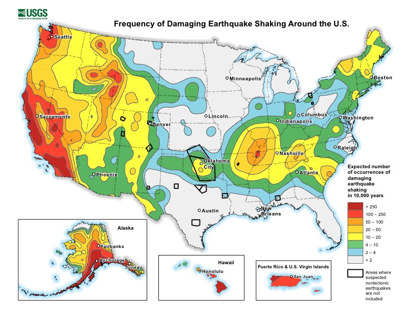
The NSHM represents an assessment of the best available science in earthquake hazards and incorporates new findings on earthquake ground shaking, seismicity, slip-rates, frequencies of various magnitudes and long-period amplification over deep sedimentary basins.
Sep 15, 2020 5 tweets 3 min read
Reminder – September is #PreparednessMonth
Week 1: Make A Plan
Week 2: Build A Kit
Week 3 (this week!): Prepare for Disasters
Week 4: Teach Youth About Preparedness
#BeReady
ready.gov/september Image Are you familiar with the 7 Steps to Earthquake Safety?
1 Secure your space
2 Plan to be safe
3 Organize disaster supplies
4 Minimize financial hardship
5 Drop, Cover, & Hold On
6 Improve safety
7 Reconnect & Restore
ow.ly/hPi250BrTe8
En Español: ow.ly/EYJF50BrTab
Sep 8, 2020 12 tweets 8 min read
To those of you who find yourself wearing a new hat, that of teacher🧑‍🏫, climb aboard for a virtual fieldtrip through #EarthScience teacher resources from @USGS and partners. Thread [1/n] #EduTwitter Like Ms. Frizzle, we hope to make learning fun, answer your questions, and provide info and resources for those of you now teaching earth science around the kitchen table.
Sep 2, 2020 9 tweets 4 min read
Here was this week’s #MindteaserMonday poll. Are you ready for all the answers to be revealed? 😸 Magnitude is the physical size of the earthquake!

Multiply the length of the fault segment that slid by the width by how far one side of the fault slid past the other side … and you’ll get a really big number. 😸 Image
Sep 1, 2020 6 tweets 4 min read
We may feel besieged by disasters on many fronts right now, & find it hard to focus on additional hazards like earthquakes. However, hazards don’t wait for each other. Winds, wildfires, smoke, hurricanes... & during a global pandemic?! Fortunately, the solutions are overlapping. While natural hazards--like earthquakes, severe weather, wildfires, hurricanes, and viruses--can abruptly disrupt our lives, we can attempt to control our outcome in the situation by being informed and prepared, and it's #NationalPreparednessMonth! #BeReady
Aug 26, 2020 7 tweets 3 min read
California may have the shaky reputation, but the entire United States can rock and roll sometimes.

Drop, Cover and Hold On if you feel shaking, then tune in as we here at @USGS_Quakes will be talking about larger felt quakes and earthquake science. 🧵 Drop Cover Hold on This account is operated by earthquake scientists. We look forward to sharing information about earthquakes and earthquake hazards, and the inner workings of geology & tectonic activity on our dynamic planet.