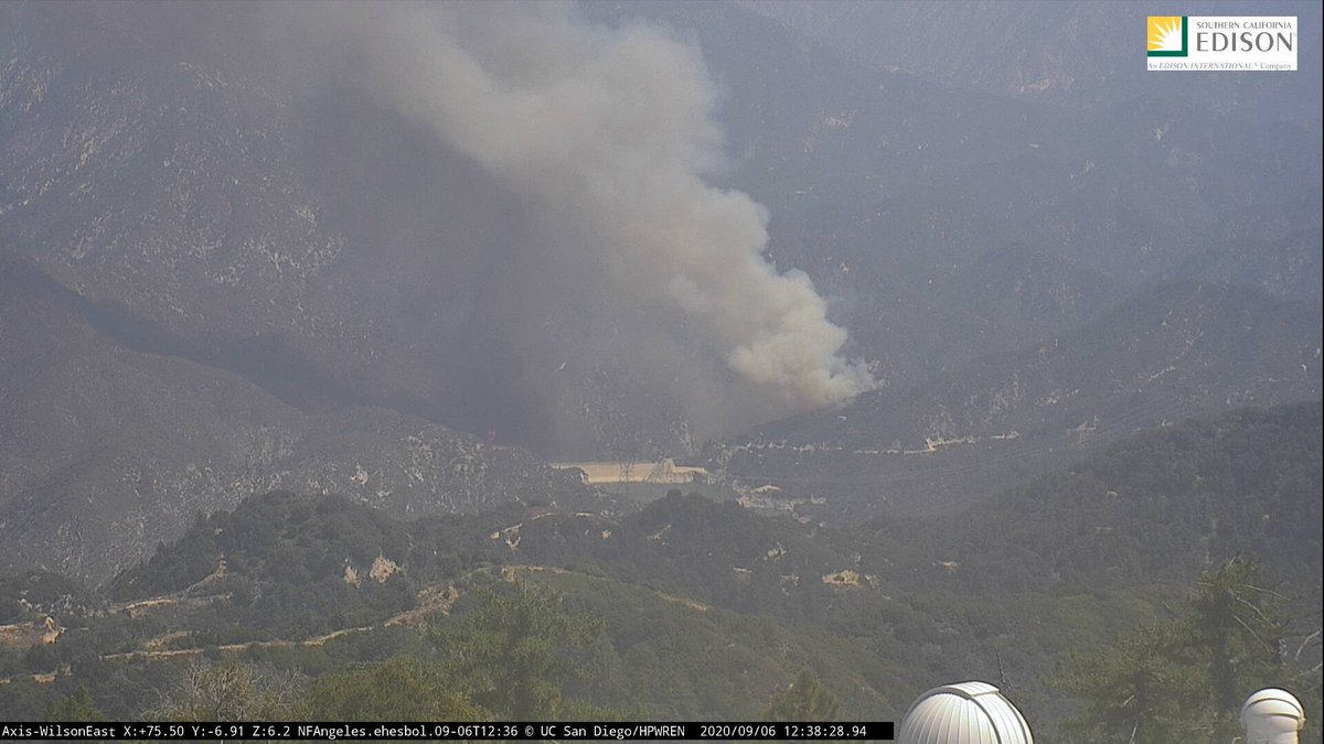
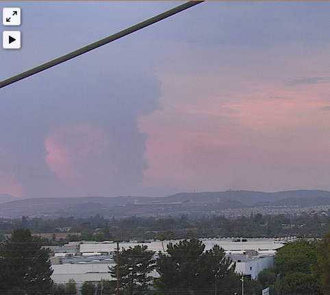
Seems like new start you can see from the Mount Wilson camera in L.A. County: 
Per @CAFireScanner, a second alarm. Unit on the ground says the fire is at least five acres.
Per WildCAD, this is the #BobcatFire.
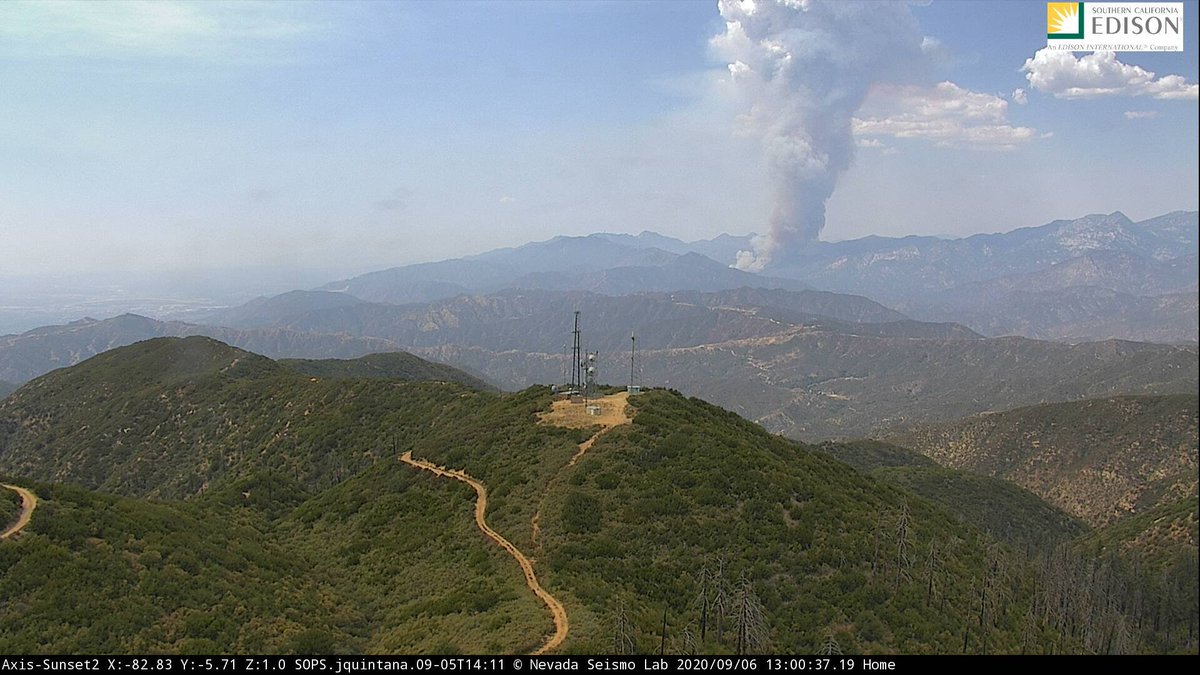
New pic of the #BobcatFire from the Sunset Peak camera:
IC says the fire 100+ acres in medium-to-heavy brush with a rapid ROS. both sides of the canyon. High growth potential. The fire is pushing toward Angeles Crest Highway.
#BobcatFire
#BobcatFire
#LACoFD sending various resources. Will be requesting #Quebec1 + #Quebec2 super scoopers to the #BobcatFire. #ANF IC also asking for three Type 1 helicopters and six Type 1 crews.
There is a "mass amount of [people recreating]" in the area of North Fork and West Fork, creating a life safety threat in addition to a structure threat in the immediate area.
#BobcatFire
#BobcatFire
I will check on this but per scanner, the Quebecs have been diverted to a fire in the Topanga area.
Quebec scoopers are now heading to the #BobcatFire. There is a possibility that this fire could push toward Mount Wilson.
- Spotting of at least a quarter-mile
- Extreme fire behavior
- FFs now going into a defensive mode
#BobcatFire
- Extreme fire behavior
- FFs now going into a defensive mode
#BobcatFire
The fire is now 400-500 acres in medium fuels with dangerous/critical ROS. It will go extended if not become a major fire, according to the IC.
#BobcatFire
#BobcatFire
The fire is now 500 acres. One head of it is heading into the Ranch Fire burn area. Unsure on evacs at the moment.
#BobcatFire
#BobcatFire
Last I checked, the #RedFlagWarning was still in effect for the L.A./Ventura county mountains, beginning at 6 p.m. Pacific.
#BobcatFire
#BobcatFire
Per scanner, the #BobcatFire is now 1,800 to 2,000 acres. Trying to paint a ridge ahead with retardant to impede progression.
A view of the #BobcatFire from Anaheim:

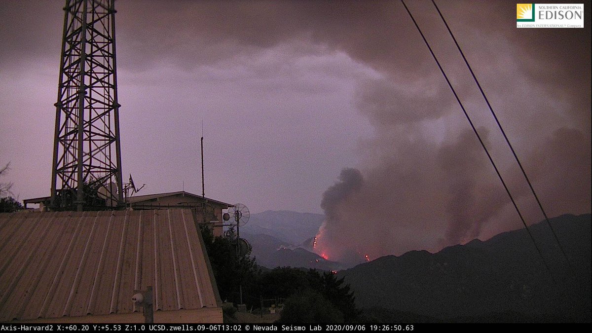
Some active flame on the #BobcatFire from the Mount Harvard camera:
Ash in Pomona:
Per CHP CAD, Highway 39 will be closed at the base of the mountain except for residents.
#BobcatFire
#BobcatFire
Angeles Crest Highway will also be closed from Mount Wilson Red Box Road to Islip Saddle.
#BobcatFire
#BobcatFire
We should have information on the "day plan" soon. Per scanner, the #BobcatFire has begun to pick up steam in places with "pretty good flame lengths." There is again concern that the fire could also impact Angeles Crest Highway.
@Angeles_NF says the #BobcatFire is now 4,871 acres and is still 0% contained. Here is today's perimeter map. I realize it doesn't really show anything specific.
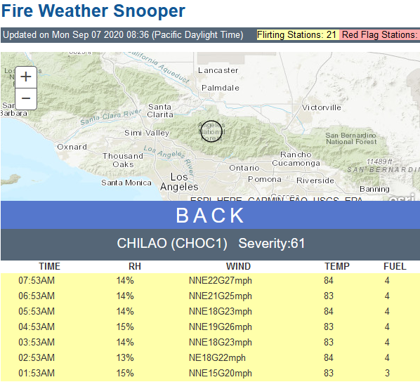
Recent readings on the snooper for the Chilao station (relatively nearby) for the #BobcatFire:
The Quebec scoopers + one copter are returning back to Van Nuys base due to poor visibility. It's not clear which aircraft will be launching once it improves.
#BobcatFire
#BobcatFire
Fifteen hours ago, the #BobcatFire was 1,800 to 2,000 acres. This morning it had ballooned to 4,800. For perspective.
Here is what I was looking for re: Mount Wilson Observatory. They did have to evacuate due to the #BobcatFire.
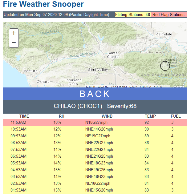
Chilao station now marked red on the snooper: winds at 18 mph - gusts to 27; RH 10%; temp of 95 F.
- As of 11:53 a.m. Pacific
#BobcatFire
- As of 11:53 a.m. Pacific
#BobcatFire
** Press conference ** #BobcatFire
Sheriff's department is working with Monrovia PD to position units ahead of time should the fire advance into communities. If you don't live in the area, stay out. If you do, make plans now (line up plans for pets and large animals).
Sheriff's department is working with Monrovia PD to position units ahead of time should the fire advance into communities. If you don't live in the area, stay out. If you do, make plans now (line up plans for pets and large animals).
The IC says the fire is likely to move south toward six communities below the mountains. Slopes are steep, fuels are dry. Pay attention to official instructions. Don't wait to get things ready.
- Concern is for Duarte and Monrovia but Santa Ana winds could impact Sierra Madre, Bradbury, etc. All could be in a warning or order. To the east is the Ranch Fire burn scar. But directly below the mountains, fuels have not burned for decades.
Trying to avoid everyone leaving at once. FD apparatus need to get in and out of the area and they can't if all streets are clogged. Pack your car up now and be ready if you might be in affected zone.
Law enforcement is on the fire now so they can figure out how to best place people to protect homes while residents are evacuated. Once the area is locked down, no one comes back in.
#BobcatFire
#BobcatFire
This Santa Ana event is not typical of what we see in the late fall in terms of how it will behave. There isn't as much cold air aloft now. The wind right now would push the fire away from Mount Wilson. The north end is burning into the Station Fire scar.
*** Much thanks to @sciencewrighter
for the press conference link!! ***
for the press conference link!! ***
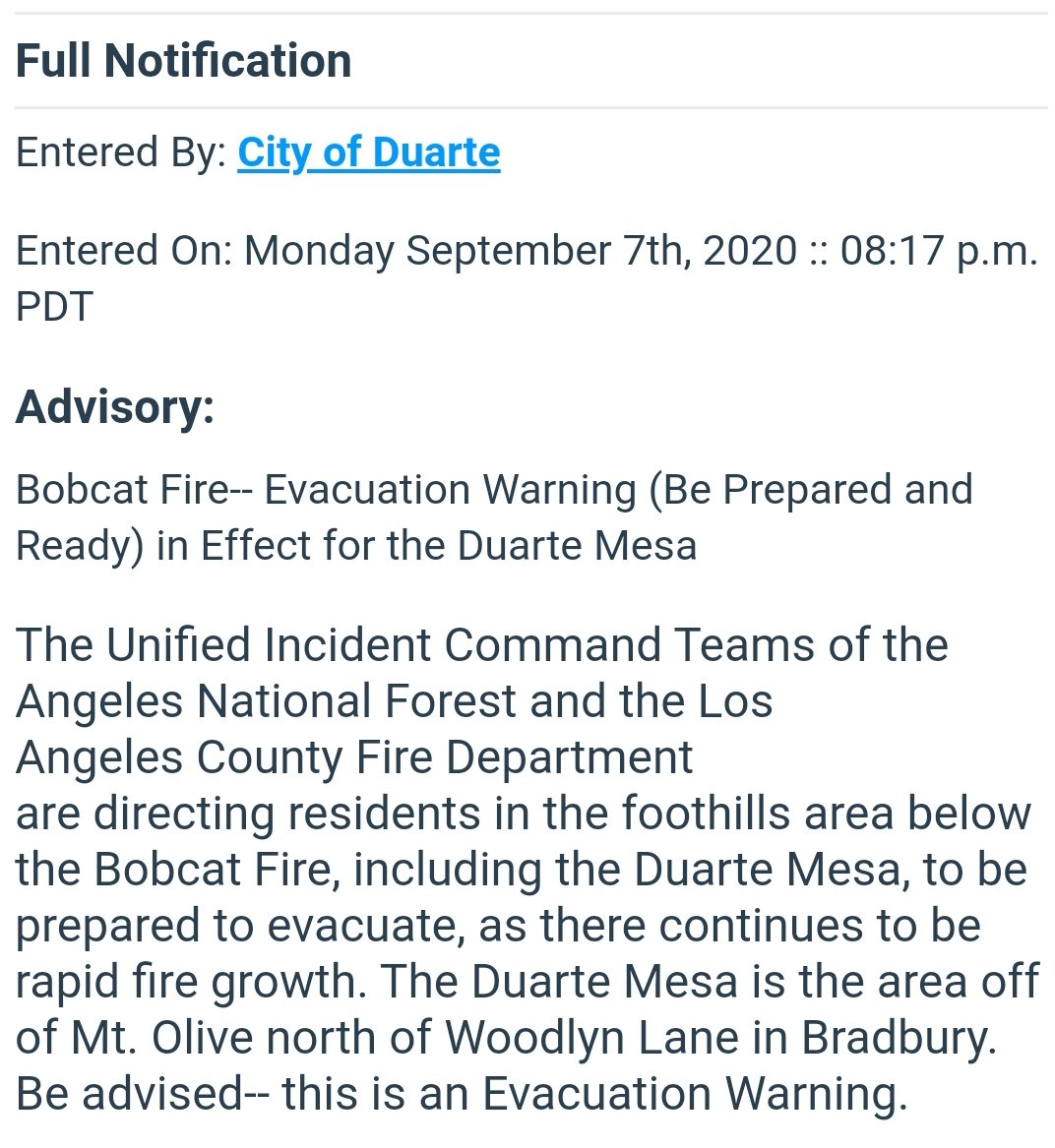
A friend forwarded me this Nixle link for the city of Duarte. The city emergency operations center is open and preparing response plans just in case. A temporary evac site has been set up at Santa Anita Race Track.
(1/×)
(1/×)

The county fairgrounds in Pomona are being set up to take large animals (up to 200 horses).
(2/×)
(2/×)
There could be possible *voluntary" evacuations for everyone north of Deodar Lane in the city of Bradbury and Duarte, including Duarte Mesa. Officials are asking for everyone in the Duarte Mesa prepare now.
(3/3)
(3/3)
(I have verified this alert on the official Nixle site -- local.nixle.com/alert/8229728)

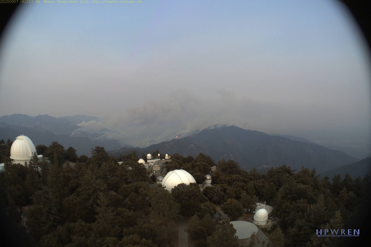
Here is a pic of the #BobcatFire from the HPWREN camera at Mount Wilson:
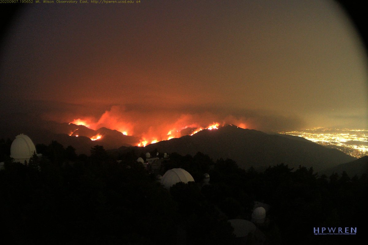
Latest shot from the HPWREN camera at Mount Wilson as night falls on the #BobcatFire
About Duarte:
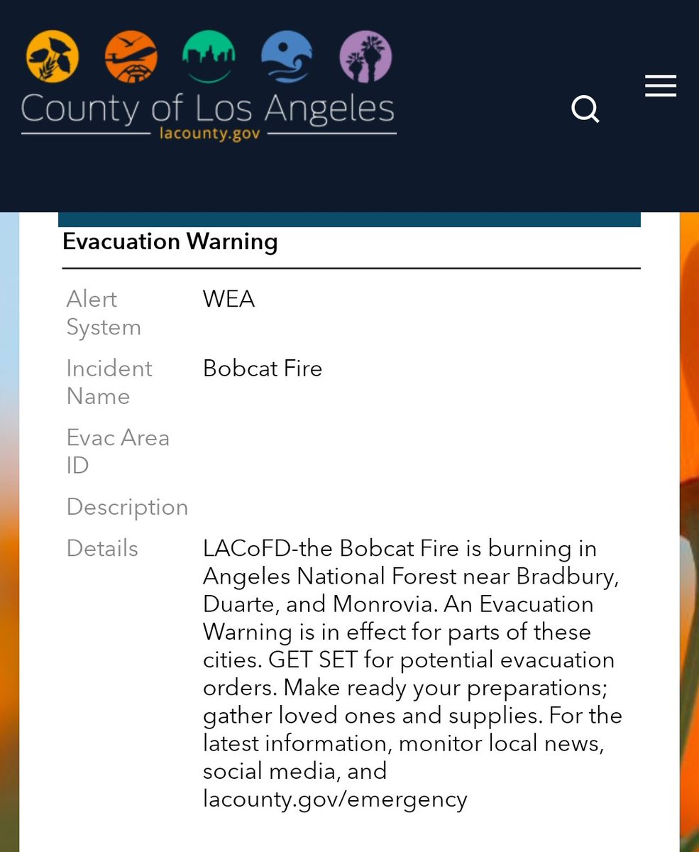
L.A. County posting here about an evacuation warning. I will try to post details shortly.
#BobcatFire
#BobcatFire
It isn't specific to neighborhoods or streets at this time. I imagine they will update this.
#BobcatFire
#BobcatFire
Note: This will take place *if* an order is issued for Monrovia. Plan now and follow your official sources: @MonroviaCA @Angeles_NF @LACoFDPIO
#BobcatFire
#BobcatFire