
We have spent the past few months documenting destruction on satellite imagery in Myanmar’s Rakhine State, answering the questions:
- WHEN, WHERE & HOW the villages were destroyed &
- HOW many buildings
This is what our project is about. Thread 🧵👇
- WHEN, WHERE & HOW the villages were destroyed &
- HOW many buildings
This is what our project is about. Thread 🧵👇
WHY are we doing this project for free?
In 2018 we used @googleearth to do an overview of the burnt villages & found 158 (image below). That was the start.
We've been diving into the detail with @KayleighRuiter to build an open database of every destroyed village.
In 2018 we used @googleearth to do an overview of the burnt villages & found 158 (image below). That was the start.
We've been diving into the detail with @KayleighRuiter to build an open database of every destroyed village.


The window of time we are looking at is destruction that occurred between 2015 and 2020 in the northern tip of the Rakhine State covering an area of more than 3,000 square kilometers.
This image shows our working space
This image shows our working space

For those of you unfamiliar with what happened around this time, there is detailed context provided here in this HRW report: hrw.org/news/2018/02/2….
A great documentary to watch for context on what happened here is by SBS Dateline: .
A great documentary to watch for context on what happened here is by SBS Dateline: .
While there has been some documentation in Rakhine State of village destruction, what we are creating is a publicly available database detailing:
- WHERE (coordinates & names)
- WHEN (date of change)
- WHAT (burned, destroyed or unknown)
- COUNT (how many buildings)
- WHERE (coordinates & names)
- WHEN (date of change)
- WHAT (burned, destroyed or unknown)
- COUNT (how many buildings)

HOW are we doing this?
We go systematically through every block of land identifying buildings, that, over time, are burned, destroyed or disappear. We document all findings in a categorised database.
We are doing this with publicly available imagery and resources.
We go systematically through every block of land identifying buildings, that, over time, are burned, destroyed or disappear. We document all findings in a categorised database.
We are doing this with publicly available imagery and resources.

WHY do we do it this way?
- So we don’t miss a single village in our documentation,
- We want to make sure our work is detailed and thorough to help researchers and investigators, and
- We want to open source our methodology and data for transparency.
- So we don’t miss a single village in our documentation,
- We want to make sure our work is detailed and thorough to help researchers and investigators, and
- We want to open source our methodology and data for transparency.


Our final product will be a website with a publicly searchable database, KML file and an easy-to-use map (pending on funding).
This will be available to the world. It’s pure open source human rights research and we’re working on it every day.
This will be available to the world. It’s pure open source human rights research and we’re working on it every day.
So how far are we from finishing this project?
Well to give you an idea, we have 3,000 square kilometres of area to cover which are separated into 105, 30 square km grid tiles.
Well to give you an idea, we have 3,000 square kilometres of area to cover which are separated into 105, 30 square km grid tiles.

So far, as of today, we have documented:
18 tiles
540 square kilometres.
So we’ve got some counting and documenting to do.
18 tiles
540 square kilometres.
So we’ve got some counting and documenting to do.

WHAT have we found in the 18 tiles we have documented already?
In that area alone we have identified around 11,000 buildings that have signs of burning or destruction.
In that area alone we have identified around 11,000 buildings that have signs of burning or destruction.

Of those 11,000 buildings, we have identified, using satellite imagery:
- 7,000 were burned
- 2,250 had signs of destruction
- 1,750 disappeared - but cause unknown due to lack of satellite imagery on google earth
- 7,000 were burned
- 2,250 had signs of destruction
- 1,750 disappeared - but cause unknown due to lack of satellite imagery on google earth

When we refer to buildings, that means on satellite imagery, we are looking at homes, schools, shops, and other essential buildings in these communities that have been burnt to the ground.
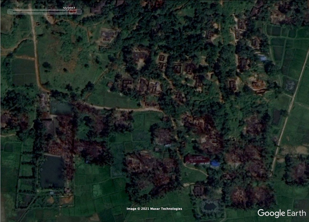
Below is an image of one of the many villages we are documenting every day.
Below is an image of one of the many villages we are documenting every day.

There’s a strength in #OSINT collaboration, so we are happy to collaborate with:
- Volunteers 🤝
- Organisations 🏦
- Funders 💰
to complete this project & present the findings in an easy-to-navigate way.
DM us for more details.
- Volunteers 🤝
- Organisations 🏦
- Funders 💰
to complete this project & present the findings in an easy-to-navigate way.
DM us for more details.
We’re doing this unfunded at the moment & need support to help pay for servers, web design, investigative resources & imagery, as well as for future projects in other areas of the world. In the meantime, please do buy us a coffee to keep us going ☕️
ko-fi.com/ocelliproject
ko-fi.com/ocelliproject
• • •
Missing some Tweet in this thread? You can try to
force a refresh


