Nguruman escarpment is located on the southern-most section of Kenya's western Rift Valley escarpment.
The valley floor (650m) contrasts sharply with the steep scarp walls that peak at 2300m.
Ewaso Nyiro south flows down the scarp towards Lake Natron.
THREAD.
Access to Nguruman is via a murram road that passes over Lake Magadi.
The landscape in this southern part of Kenya is one of outstanding Rift valley features. Volcanic mountains (Ollorgesaille, Gelai) reflect on the glassy surface of RV lakes with huge escarpments on the flanks
A small township is located at the foot of Nguruman escarpment where the landscape changes drastically from parched, dry earth to green, riverine zone.
There's a thriving horticultural community that grows vegetables and some of the sweetest mangoes you'll find anywhere.
Directly south of this Magadi/Nguruman & Lake Natron area is the Crater Highlands of Northern Tanzania with famed volcanic features like Ngorongoro crater & Mt. Oldonyo Lengai.
A tarmac road to link these two scenic regions would boost exploration and tourism in both Kenya & TZ
• • •
Missing some Tweet in this thread? You can try to
force a refresh
Mau forest complex is the biggest closed-canopy forest block in Kenya. It is the source of numerous rivers including Mara river which sustains the Mara-Serengeti ecosystem.
Google Earth's timelapse feature gives a sorry picture of the forest's destruction since 1984.
Thread.
Mau has several forest blocks. The sections to the East, South and South West have suffered the biggest loss of forest cover since 1984.
The first timelapse shows the loss of forest cover in Maasai Mau, largely located in Narok County
The Mau East section in Nakuru county was almost cleared out since 1984, with only the highest sections along the Rift valley escarpment left intact
The poor quality of air in Nairobi is a matter that needs urgent action by policy makers in Kenya.
These two photos show the exact same view before and after the rains. The dense layer of smog over the eastern side of the city blocks out the view of Mt. Kilimambogo.
THREAD.
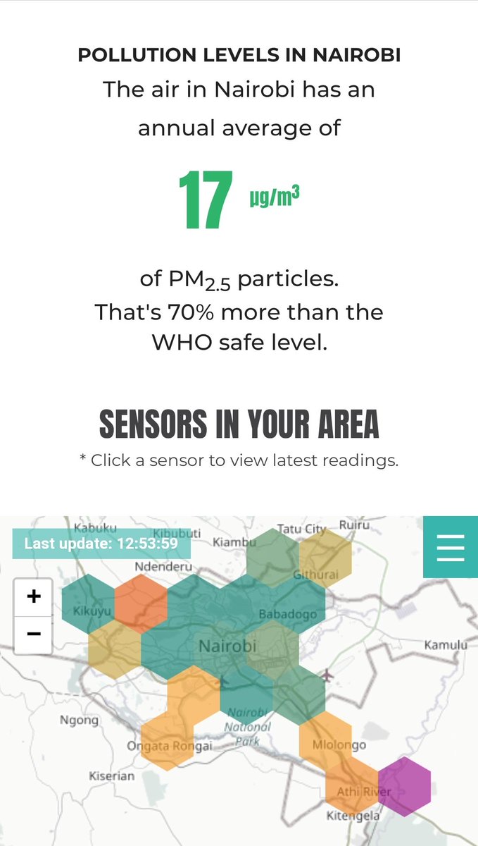
Nairobi has dangerously high level of toxic particles in the air. As per sensors.africa air quality tracker, Nairobi has particle levels that are 70% higher than the WHO recommended safe levels.
This is a damning statistic for a city that host @UNEP
The sensors.africa map shows how air quality decreases in areas with fewer trees and locations close to major highways. These include areas like Mlolongo, Pipeline, Rongai, Kikuyu and Ruiru.
This can be attributed to poor urban planning & unregulated vehicle emissions.
Nairobi experiences relief rainfall. This occurs when moist air vapour is blown in from the Indian ocean. Increase in altitude inland and the resultant decrease in temperature causes the air to condense and form clouds that rain over highlands.
Relief rainfall occurs over highlands in Kenya including the highlands east & West of the Rift valley as well as Mt. Kenya. The graphic below highlights the inland movement of moist air from the ocean and precipitation in the highlands.
Lake region experiences convectional rain
As shown in this rain graphic by @HewaniKE cloud movement and rain over Nairobi almost always follows and East to West pattern as moist air is blown in from the Indian ocean.
The graphics provide a fascinating insight on rain in the capital city
A map showcasing the tree cover in Kenya (average canopy height of 3m).
While Kenya has limited forest cover (only 6%) the country has a significant canopy coverage that is not necessarily forest. @KeForestService classifies forests as areas having > 30% tree cover.
Thread.
It goes without saying that the areas with the highest average canopy height and forest coverage are the main water towers in the country (Mt. Kenya, Aberdares, Mau and Cherangany Hills).
Mt. Elgon on the Uganda border also ranks in this category.
The main water towers are highland areas. In adjacent localities, highland relief rainfall and good soils support agricultural activities. While limited in size, these areas are some of the most densely populated. Kericho (pictured) adjacent to Mau is an example.
Prosopis juliflora or Mathenge is an exotic drought-resistant tree of American origin that has been widely used for afforestation in Northern Kenya.
A thread on how the aggressive tree species has proved destructive to the pastoralist economy.
The trees have pods that are eaten by livestock and spread over large areas where they quickly grow. The deep tap roots of Mathenge trees ensures the trees stay evergreen once they take root.
The tree particularly thrives along water sources such as rivers banks & flood plains.
The trees colonize whole areas forming thick, impenetrable bushes that restrict access to grazing land and water sources.
Small animals like goats and sheep frequently get lost in the thickets to be devoured by wild animals.
A hydrological map of Kenya with colour-coded watershed areas.
In this thread, we'll highlight the source of each river, the watershed area and the direction of flow.
The rivers of Kenya flow from three main sources: the escarpment and highlands east of rift valley (Aberdares), highlands west of the rift valley (Mau) and Mt. Kenya.
Mt. Elgon & Kilimanjaro on the border with our neighbors also act as sources of rivers that flow within Kenya.
The rivers that rise from the western escarpment and western highlands flow west into major rift valley lakes. These include Nzoia, Yala, Kuja (Migori), Sondu and Mara that flow into Lake Victoria.
Turkwel (Mt. Elgon) and Kerio (Elgeyo escarpment) flow north to Lake Turkana.