Christiaan Triebert Profile picture
Apr 22, 2021 7 tweets 6 min read Read on X
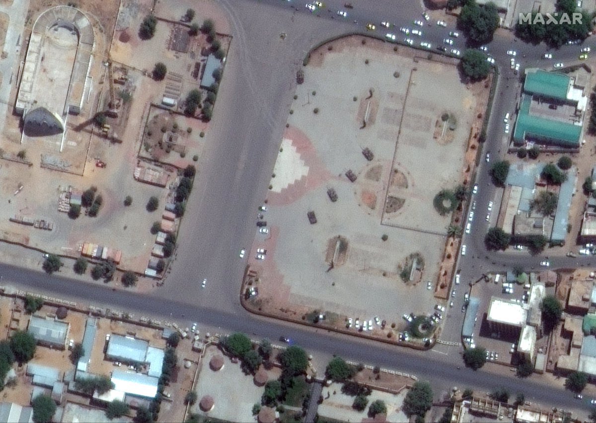
Satellite imagery of Ndjamena reveals the heightened state of alert in the Chadian capital after President Idriss Deby was killed whe commanding troops at the front on April 20. 🛰️📸: @Maxar (google.com/maps/@12.11039…)
The death of Déby, who ruled the country with an iron fist for three decades, comes barely a week after FACT rebels crossed from Libya into Chad. One of their shells apparently exploded near Déby's vehicle. More by @declanwalsh/@AdamouNdjam/@ElianPeltier: nytimes.com/2021/04/22/wor…
The FACT (Front for Change and Concord) rebels threatened to march on Ndjamena this weekend. Whether they can deliver on that threat is unclear: Chadian Army claim heavy rebel losses and foreign officials are unsure how far they are from the capital.
As fighting in Libya ended, Chadian fighters returned home for the uprising they launched against Déby on April 11. Small but interesting detail: one of Toyota's seen in footage published yesterday, apparently from around Miski, indeed shows a Libyan license plate.
The FACT rebels appeared to be traveling in the same kind of armored vehicles that the United Arab Emirates had donated to Haftar's Libyan National Army, @_hudsonc told @nytimes. They may have brought advanced weaponry from Libya to Chad too. nytimes.com/2021/04/22/wor…
It's worth pointing out that some of the footage of the FACT fighters is archival, not recent — e.g. this footage (left image, which includes an Emirate-made Panthera T6) which was already published back in July 2020 (right image) viva.co.id/militer/milite…
Another example: a video of heavy exchange of fire allegedly shows “a big war going on in Chad.” Piga Firimbi's @truthjabali took a closer look and found that the video is actually from Iraq. pigafirimbi.africauncensored.online/chad-video-che…

• • •

Missing some Tweet in this thread? You can try to force a refresh
 

Keep Current with Christiaan Triebert

Christiaan Triebert Profile picture

Stay in touch and get notified when new unrolls are available from this author!

Read all threads

This Thread may be Removed Anytime!

PDF

Twitter may remove this content at anytime! Save it as PDF for later use!

Try unrolling a thread yourself!

how to unroll video
  1. Follow @ThreadReaderApp to mention us!

  2. From a Twitter thread mention us with a keyword "unroll"
@threadreaderapp unroll

Practice here first or read more on our help page!

More from @trbrtc

Mar 9
New footage reveals an apparent U.S. or Israeli strike near a boys' school in Abyek, west of Tehran, on Feb. 28. Satellite imagery suggests a comms tower was the intended target, but flying debris killed a child on the playground. Story w/ @Parinlalala nytimes.com/2026/03/09/wor…
The footage originates from multiple security cameras. It shows an ordinary morning; boys playing on the playground. It's just hours after the first joint U.S.-Israeli strikes, so school are in session. Then, an explosion is seen at the top of the screen.
We geolocated the footage to the Imam Reza Elementary School for boys in Abyek, a small city in the Qazvin Province, west of Tehran: 36.045062, 50.542351. The footage from the interior shows the blast damaged the school itself too.
Read 5 tweets
Mar 3
What you're looking at is not a sunrise — it's the Russian LNG tanker ARCTIC METAGAZ (IMO 9243148) struck by a massive explosion in the Mediterranean this morning. Photographed by crew aboard a merchant vessel, via Vanguard Tech. Image
Image
Image
Image
Photos were taken ~04:00 local (03:00 UTC), looking towards Libya. ARCTIC METAGAZ had been running dark (AIS off, see @MarineTraffic screenshot) but had traveled southeast of Malta before the explosion (150NM per Maltese media, h/t @malte_humpert @sanjanamv @DefMon3). Image
At the time of the suspected (naval) drone attack, the ARCTIC METAGAZ was fully loaded near Murmansk with about 4 tanks of LNG, per @Kpler data. That's probably about $50 to $60 million worth in Russian gas. Image
Read 4 tweets
Feb 28
We obtained the first known satellite image of Ayatollah Ali Khamenei's compound in Tehran. There are several destroyed buildings. While the current whereabouts of Iran's supreme leader are unknown, the compound is generally used as his official residence. 🛰️📸: @Airbus Image
*first publicly released satellite image

Either way, it goes to show that triangulating the lines of sight from four geolocated videos lead precisely to a main strike location in Tehran.
More updates on the @nytimes live blog: nytimes.com/live/2026/02/2…
Read 5 tweets
Feb 28
Israel has launched a daylight attack on Tehran, just now. Multiple explosions have been reported in Iran's capital. It isn't clear yet what was targeted, so starting a thread with geolocations.
This photo, showing thick smoke plumes, was taken from Hasan Abad Square (میدان حسن‌آباد), looking northwest. Reference photo attached (). @GeoConfirmed: 35.686144, 51.410156. google.com/maps/@35.68614…Image
Image
@GeoConfirmed This video, posted by a semi-official Iranian news agency, shows thick smoke rising near Pasteur St (خیابان پاستور), where key government institutions are located. Point-of-view is southwest. Geolocation in tweet below.
Read 55 tweets
Jan 21
The aftermath of the Jan. 8 fire in the historic bazaar of Rasht, northern Iran, is visible in satellite imagery. The image is accessible via @Soar, a relatively new free platform aggregating satellite data from multiple sources, including @CopernicusEU.
The fire broke out amid nationwide anti-government protests, and Rasht's bazaar was a focal point of unrest, including clashes and strikes by merchants. Iranian authorities blame protesters for setting the fire, eyewitnesses dispute that. factnameh.com/fa/fact-checks…
Reports from activists and social posts suggest ~300 shops were destroyed or heavily damaged. Several 19th century sarays (covered market sections) burned completely. Coordinates: 37.279829, 49.589358. Link to the @Soar platform. And h/t @x4rius. soaratlas.com/satellites?pos…
Read 9 tweets
Jan 9
The U.S. in is in the process of seizing OLINA in the Caribbean near Trinidad, per @Reuters. It's flying a false flag of Timor Leste. It's loaded with oil cargo from Venezuela, per @Kpler and @TankerTrackers. And last known location is 12.16769, -62.6113, per @oballinger. Image
The tanker was hit by U.S. sanctions last year in re: Russia’s war in Ukraine. At the time, it was named MINERVA M, but it can still be identified by its IMO number, 9282479, which appears in related references. OFAC: ofac.treasury.gov/recent-actions… Reuters: reuters.com/business/energ… Image
A U.S. Coast Guard and Navy team has boarded and seized the vessel, per @EricSchmittNYT. nytimes.com/live/2026/01/0…Image
Read 8 tweets

Did Thread Reader help you today?

Support us! We are indie developers!


This site is made by just two indie developers on a laptop doing marketing, support and development! Read more about the story.

Become a Premium Member ($3/month or $30/year) and get exclusive features!

Become Premium

Don't want to be a Premium member but still want to support us?

Make a small donation by buying us coffee ($5) or help with server cost ($10)

Donate via Paypal

Or Donate anonymously using crypto!

Ethereum

0xfe58350B80634f60Fa6Dc149a72b4DFbc17D341E copy

Bitcoin

3ATGMxNzCUFzxpMCHL5sWSt4DVtS8UqXpi copy

Thank you for your support!

Follow Us!

:(