Where are India’s biologically-significant Open Natural Ecosystems (ONEs)?

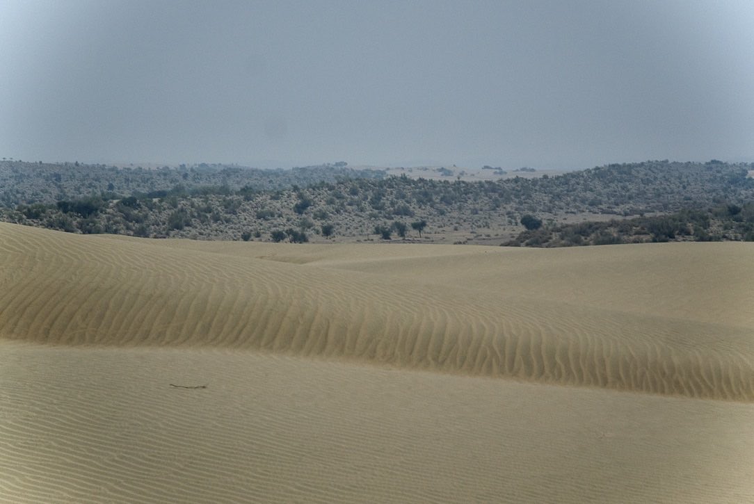
Thread 👇🏽 on a new, open, and analysis-ready dataset on the distribution of India’s beautiful and beleaguered semi-arid Open Natural Ecosystems. (Representative image for each of the ecosystem types).
A large fraction of India’s landmass is semi-arid (annual rainfall < 1000 mm). The native vegetation in this zone is made up of grass, herbs and shrubs. They are often naturally without trees, and if at all trees do occur, cover is sparse. Yet, ONEs are staggeringly diverse.
Mirroring the diversity of habitats, ONEs also have a remarkable diversity of animal species, many of which are unique to the Indian subcontinent.
ONEs also are our primary rangeland habitats, which sustain grazing-based livelihoods of millions from of pastoral and agro-pastoral communities across the country.
These communities, with their diverse and rich pastoral and agro-pastoral cultures, have also had a long history of coexistence with these ecosystems, and their unique wildlife.
Besides being home to unique life-forms, and providing sustenance to local communities for millennia, they provide valuable ecological services. Research shows that, under certain environmental conditions, ONEs can sequester *more* carbon, than if trees were planted on them!
Yet, India’s ONEs continue to be misunderstood, misrepresented, and destroyed routinely. Successive governments have officially termed them 'wastelands', and led the charge against them, seeking to make them ‘productive’ and to ‘develop’ them, thereby incentivising their erasure.
Such ill-informed efforts to ‘develop’ ONEs result in a range of ecological incursions, such as the road cutting across this grassland here. But, in recent times, the two most significant threats to ONEs come from, wait for it, renewable energy and tree-planting projects.
Renewable energy technologies—wind and solar power, in particular—have become pivotal in a low-carbon energy economy. But, both wind and solar power are heavily reliant on the availability of open spaces. What better places to target for such ‘development’ than our ‘wastelands’?!
But here is the catch: to generate hundreds of gigawatts of power at the grid-scale, we end up with a geographical & ecological footprint of energy production—even with wind and solar technologies—that are environmentally and socially just as huge as that of a large hydel dam.
This (entirely avoidable) overlap of renewable energy projects and critically endangered fauna like the Great Indian Bustard has led to serious contestations going all the way to the Supreme Court. More on that here:
But the scales are already tilted heavily against ONEs. Our remaining ONEs are rapidly being lost to colossal renewable energy projects that may be well-meaning but are ill-conceived and poorly-implemented.
Likewise, in recent years, there has been a spurt in ill-conceived plans of tree-planting—even where they were never meant to be—as a way of capturing atmospheric carbon into biomass. As a result, wildlife habitats in ONEs are being destroyed as they get planted over with trees.
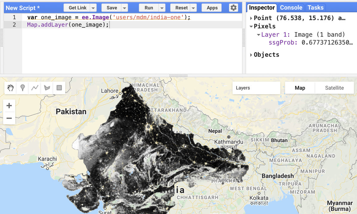
A key knowledge gap that has constrained us from more effectively protecting our valuable open natural ecosystems is the absence of a reliable map of the distribution and extent of our Open Natural Ecosystems. This, specifically, is the gap that our dataset hopes to bridge.
To make the visualisation and inspection of our data at state/district levels easy, particularly for journalists and policy-makers, we built an interactive app, which is available at http://tiny.url/open-natural-ecosystems.
For researchers, our data are available as an analysis-ready image within the Google #EarthEngine platform. From here, specific areas of interest can be exported and downloaded, or the layer called in QGIS via the GEE plugin.
More detail about our motivations and methods is available in this preprint: Mapping the distribution and extent of India’s semi-arid open natural ecosystems essoar.org/doi/10.1002/es…
We—@atree_org & @abi_vanak—see this map as the first step in a long road to making our ONEs first-class ecological citizens, worthy of care and conservation. This is work in progress, to be iterated and improved upon. So please do share your comments, corrections, or suggestions.
This video unfortunately didn’t seem to load in the threaded tweet…

• • •

Missing some Tweet in this thread? You can try to force a refresh
 

Keep Current with M D Madhusudan

M D Madhusudan Profile picture

Stay in touch and get notified when new unrolls are available from this author!

Read all threads

This Thread may be Removed Anytime!

PDF

Twitter may remove this content at anytime! Save it as PDF for later use!

Try unrolling a thread yourself!

how to unroll video
  1. Follow @ThreadReaderApp to mention us!

  2. From a Twitter thread mention us with a keyword "unroll"
@threadreaderapp unroll

Practice here first or read more on our help page!

More from @mdmadhusudan

26 Jun
A thread about the new 10m global landcover dataset released by ESRI and Microsoft, a quick look at how it fares for India, and some thoughts on making it better.

livingatlas.arcgis.com/landcover/
2/ Yesterday, @ESRI and @Microsoft, together with @ImpactObserv, released a globally-consistent landcover dataset at 10m resolution, obtained from classifying Sentinel2 imagery.

Foremost, what is fantastic and exemplary is that they released their data under a CC-BY 4.0 license.
3/ The possibilities of a 10m global landcover dataset are tantalising. And expectations high. Especially, when it describes itself by headlining detail and accuracy.
Read 16 tweets
16 Jun
Why would a shoddily-written, poorly-titled hit-piece—targeting a critically endangered bird and its mistreated grassland habitat, both struggling on the fringe of India's conservation consciousness—make it so big across so many news channels? Image
2/ To begin with, Bloomberg Green fearlessly ran down the Great Indian Bustard, saying that efforts to save this ‘slow’, ‘easily-frightened’ bird with ‘bad eyesight’ held risks for ‘green energy’ projects, God's very own gifts to the ‘wastelands’ of an energy-hungry nation. Image
3/ Instead of making other news outlets cautious, this piece was syndicated across multiple big business news channels. It was mostly run as-is, but the title was often creatively spun to ensure the bird got a good rap and a bad rep. ImageImageImageImage
Read 8 tweets
19 May
Last week, one of the finest, gentlest humans I've ever known—Suresh Puttaswamy—lost his fight to Covid-19. His loss is devastating, not only to his family, but literally to tens of thousands of people with whom—and for whom—he toiled tirelessly, but quietly, his entire life …1
Although Suresh never received the recognition he truly deserved, he was a leader who cared deeply, both for nature and about people. His contributions to the conservation of Bandipur Tiger Reserve, and to the well-being of its adjoining villages, are, in my view, unrivalled …2
Growing up, Suresh understood two things well: hardship and nature. Dividing time between parents working on a tea-estate in the Nilgiris, and his grandmother living in a fringe village of Bandipur Tiger Reserve, he knew all too well what it was like to live on the edge …3
Read 15 tweets
30 Apr
Two hours in the queue. The time slots given by the stupid CoWIN website don’t mean a thing in the difficult reality of your vaccination centre. Good old jostling is the only way. And oh, if know a shameless bureaucrat, they can always help you jump the queue.
Besides the elderly, the people whose life this registration website/app makes unspeakably worse are the immunisation workers. They have been forced to handle the unrealistic unmet expectations set by this site, and the public anger it precipitates.
And the hours people are forced to spend in close contact will itself multiply transmission risks greatly. And remember, the deluge hasn’t yet been let loose. It will be the cruelest irony that immunisation is itself becoming such a transmission risk.
Read 8 tweets
18 Feb
Geospatial folks in India: given the recent talk of liberalising access to geospatial data, can we, in this thread, list civilian-use geospatial datasets available with governments, that, in your view, must be made freely available to for public use?

I’ll go first… PLEASE ADD
A single authoritative, official and regularly updated GIS-ready dataset of all political and administrative boundaries, from international boundaries down to revenue village/ ULB ward boundary.
Analysis-ready time-series of the NRSC’s 1:250k and 1:50k Land Use Land Cover datasets. (By analysis-ready, I mean GeoTiffs, not via WMS, as currently available).
Read 6 tweets
17 Jan
The unlikely, inspiring and heartwarming story of an online Kannada-English dictionary, Alar/ಅಲರ್, alar.ink:
Every so often, an unfamiliar or difficult Kannada word catches me without a dictionary at hand. Earlier, I visited a website called KannadaKasthuri, with a decent Kannada-English (& KN-KN) dictionary. Its now gone & I’ve disliked the alternatives. Then, I stumbled upon Alar…
Alar/ಅಲರ್, alar.ink, is a brilliant site: exhaustive, simple, fast and ad-free. That’s not all. Its word corpus is completely open. The algorithm that does its phonetic indexing is open source. So is the software that drives it. But its story only gets better…
Read 8 tweets

Did Thread Reader help you today?

Support us! We are indie developers!


This site is made by just two indie developers on a laptop doing marketing, support and development! Read more about the story.

Become a Premium Member ($3/month or $30/year) and get exclusive features!

Become Premium

Too expensive? Make a small donation by buying us coffee ($5) or help with server cost ($10)

Donate via Paypal Become our Patreon

Thank you for your support!

Follow Us on Twitter!

:(