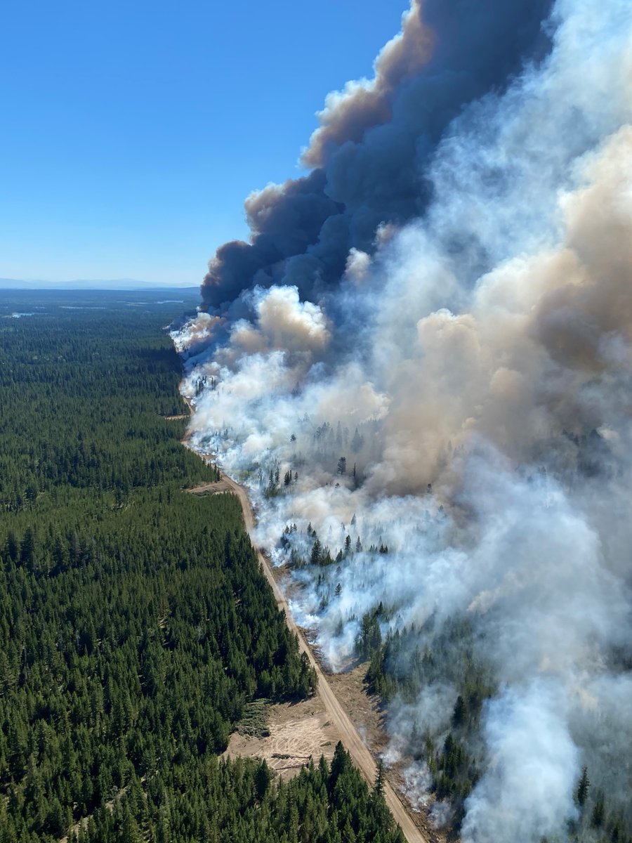
If conditions on site are favourable later this morning, the #BCWildfire Service will be conducting a planned aerial & hand ignition on the Flat Lake wildfire (C41602). Smoke is anticipated to be visible from #100MileHouse, #70MileHouse, #BCHwy97 and the surrounding communities.
This planned ignition operation is being considered for the N edge of the fire perimeter in the area south of Moose Valley Park, between Gustafsen Lake & Holden Lake. The purpose of the planned ignition is to remove unburnt fuels between the fire perimeter and pre-determined...
...control lines (roads and machine guards) and will cover approximately 600 hectares. This will bring the fire perimeter to more easily accessible locations where ground crews can safely work and deliver water directly to the fire’s edge.
In preparation, firefighters will use hand ignitions to blackline the edge of the containment line prior to aerial ignitions and aviation support will cool down areas prior to ignition. Aviation support will remain on site throughout the day to support.
For more information on this wildfires and other current Wildfires of Note, visit: ow.ly/s0tR50Fn6aR
UPDATE: This planned ignition was successful in removing unburned fuels between the previous fire edge (south of the containment line) and the control line. Firefighters will remain on site to patrol and conduct mop up operations in the area. #100MileHouse#BCWildfire
Planned ignitions, like the one seen here on the Flat Lake wildfire, are an essential and effective tactic that the #BCWildfire Service uses to help contain very large wildfires. For more information on this wildfire, visit its Wildfire of Note webpage: bcfireinfo.for.gov.bc.ca/hprScripts/Wil…
• • •
Missing some Tweet in this thread? You can try to
force a refresh
“My name is Kyle Young and I am an Incident Commander with the #BCWildfire Service. I am writing this post rather than sharing a video message because, frankly, it would be too emotional for me."
"I am someone that ground crews, my kids, and many other people, look up to for guidance through these challenging seasons. I have been doing this job for 16 years. I am a third generation wildland firefighter, following my father and grandfather."
"I have a long history within this organization and the love I have for this job is what drives me every day, along with the support I receive from my family and co-workers."
@environmentca has issued a Heat Warning for the South Coast of British Columbia. Thursday and Friday will be the hottest days of the week. For more information go to: weather.gc.ca/warnings/index….
On Aug. 7, a band of thunderstorms crossed the area spanning north of Campbell River onto the mainland north of Powell River. Close to 160 lightning strikes were detected, resulting in 5 fires. In the below image, the blue and green markings identify where lightning has struck.
The Coastal Fire Centre is preparing to respond to any holdover fires which may become visible as a result of hot weather and lower relative humidity’s over the coming days. With a holdover lightning strike, there can be a delay in a #BCwildfire becoming visible.
If conditions on site are favourable this morning the #BCWildfire Service will be conducting aerial planned ignitions on the Flat Lake wildfire (C41602), approximately 27 kilometres southwest of #100MileHouse.
Smoke is anticipated to be visible from 70 Mile House, #BCHWY97 and the surrounding communities.
This planned ignition operation is being considered for the southwest corner of the fire perimeter in the area between Meadow Lake Road, Dog Creek Road and the Gustafson East FSR.
The purpose of the planned ignition is to remove unburnt fuels between the fire perimeter and pre-determined control lines (roads and machine guards) and will cover approximately 800 hectares.
As new technology emerges, the #BCWildfire Service is reminding the public to understand their best uses. Although online fire detection tools, such as MODIS, can be helpful to gather information about wildfires in your area, they can also cause a lot of confusion and anxiety.
MODIS uses satellite sensors to record the intensity of electromagnetic radiation from Earth in various spectral wavelengths or channels. This means heat signatures are picked up by the satellite and the map is populated with pixels.
The satellite can flag smoke, or large open areas such as cut blocks, as a heat signature. It will also pick up a heat signature if the ground around a fire is cooler than the fire itself, for example in the morning.
This morning, July 31, 2021, areas of the Fraser Zone in the Coastal Fire Centre received multiple lightning strikes resulting in reports of two wildfires on the northern half of Harrison Lake, northeast of #Chilliwack. #BCWildfire
No fires have been reported on the southern portion of the lake. The lightning moved across Harrison Lake in a northeastern direction. Resources have been dispatched and are now attending these fires.
Currently there are two confirmed with more expected to be discovered as the day progresses.
North End Long Island (V12262) – this fire is currently .5 hectares in size and aerial resources including air tankers are on site.
If conditions on site are favourable later this morning the #BCWildfire Service will be conducting small scale planned ignitions on the Flat Lake wildfire (C41602) approximately 27 kilometres southwest of #100MileHouse.
Smoke is anticipated to be visible from #70MileHouse, HWY 97 and the surrounding communities.
This planned ignition operation is being considered for the south edge of the fire perimeter in the area between Alberta Lake, McKinley Lake and the 3900 road.
The purpose of the planned ignition is to remove unburnt fuels between the fire perimeter and pre-determined control lines (roads and machine guards) and will cover approximately 200 hectares.