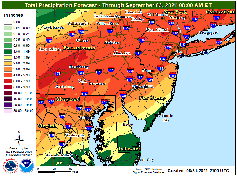
Main impact from #Ida as it moves through will be heavy rainfall, flash flooding and river flooding. Forecast rainfall amounts from local NWS offices.
The forecast rainfall from #Ida pushes a number of local creeks and rivers into the moderate flooding category. Here is the Schuylkill River at Norristown.
Here is Perkiomen Creek at Graterford, PA.
Here is Brandywine Creek at Chadds Ford, PA.
And the Raritan River at Bound Brook, NJ.
Again, all these graphs are based on forecast rainfall. They will be updated as the rainfall arrives and actual reports come in. Be prepared for changes. Monitor the forecasts during the day Wednesday.
• • •
Missing some Tweet in this thread? You can try to
force a refresh
Have read this article and feel that it provides some insight into what happened with the #Ida flooding in NYC. I will sound like a one note horn, but I still feel this is primary a failure of political leadership. 1/x
The weather community is doing its part in looking at communication of the event, what was in the forecast and the warnings and when was it issued, but communication is a two-way street, and senior political leadership in NY/NYC did a stunning job of not listening. 2/x
Even if you are buying what the senior political leadership is selling, i.e., the storm was worse than forecast (Spoiler alert: The forecast and warnings were just fine), there is a level of obliviousness during the event that is simply negligent. 3/x
With the focus on tornado impacts (and rightfully so), the major flooding threat continues unabated. Along with widespread flash flooding, local creeks and streams are well over flood stage.
East Branch Brandywine Creek below Downingtown PA now approaching Major flooding.
Perkiomen Creek at Graterford, PA now experiencing Moderate flooding. Major flooding expected with forecast 5th highest stage of record.
West Branch Brandywine Creek at Modena PA now second highest crest on record and less than a foot away from all time record set back in June 1973.
Forecast impacts from river flooding due to #Ida rainfall getting more serious. Now forecasting the third highest crest on record on the Schuylkill River at Philadelphia, tying the crest of 14.7 feet set back in 1933.
Perkiomen Creek at Graterford, PA now forecast to set 4th highest crest on record.
Raritan River at Bound Brook, NJ now forecast for 6th highest crest on record.
A few more thoughts on yesterday's storm and the response to it. This will take a number of tweets and I will try to do them quickly, but I may get interrupted. If that happens, please be a little patient with me. 1/x
I'll recognize up front that the snowfall forecast was adequate in some locations, but pretty bad in other locations. Nonetheless, at least here in New Jersey, you're being scammed by senior political leadership (yeah, I know, what a shocker) 2/x
Please remember the entire forecast. Many locations that got more snow than forecast also received less sleet and freezing rain than forecast. The atmosphere stayed colder than forecast, and you traded less sleet/freezing rain for more snow. 3/x