Days after we published our investigation on the CIA's Salt Pit/Eagle Base site near Kabul, the Taliban allowed journalists in. I'll thread some of the ground visuals with a note where it is in the nearly two-square mile compound.
Here are some of the main locations inside the CIA compound. To the south: the Salt Pit (where the CIA tortured detainees), the original Eagle Base in the former brick factory, shooting ranges and heliport. To the north: new Eagle Base incl. ammo depot and training facility.
The LA Times' @nabihbulos is here in the northern part of the compound, what appears to be an ammunitions depot and/or storage facility that was partly blown up as the CIA and the Afghan units it trained here left.
This building, filmed by TRT's @Ali_Mustafa, is pretty recent: construction started in late 2019 and was only finished by early 2021. It's situated adjacent to the original outer walls of the 2002-2004 Salt Pit.
Looking southeast from inside the expanded Salt Pit site: 34.57731, 69.29181. Filmed by TOLO News' @AbdulhaqOmeri.
The CIA's helipad at Salt Pit has been around since at least 2014, but the 4 hangars you see on @nabihbulos' photo are relatively new. Construction was only completed in late April 2021 — after Biden's announcement that US would leave the country by Sept.
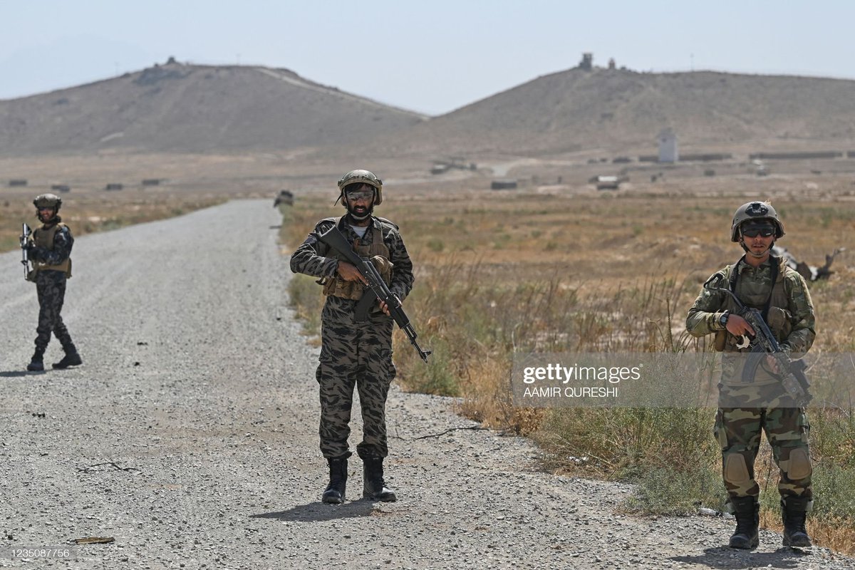
AFP's photographer @aamirqureshi14 took a lot of photos at the CIA compound, showing that the Taliban's elite Badri 313 Battalion is guarding the site. gettyimages.com/detail/news-ph… Members of the Taliban Badri 313 military unit patrol along
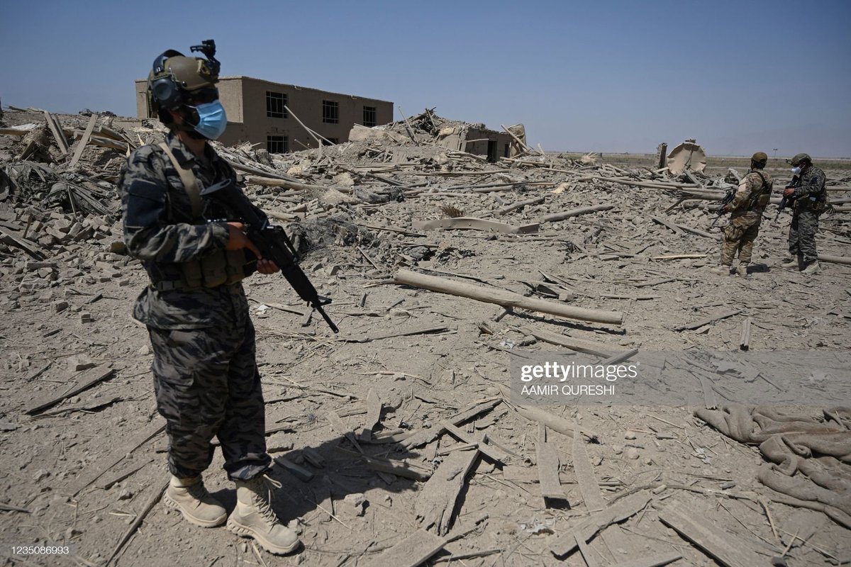
Another photo by AFP's @aamirqureshi14 shows the apparent training facility, part of new Eagle Base, in the northeast of the CIA's compound, which was almost completely wiped off the map by the controlled detonations. Geolocation: 34.58555, 69.29927. gettyimages.com/detail/news-ph… Members of the Taliban Badri 313 military unit walk amid the
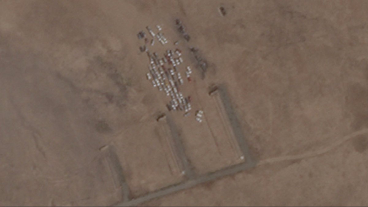
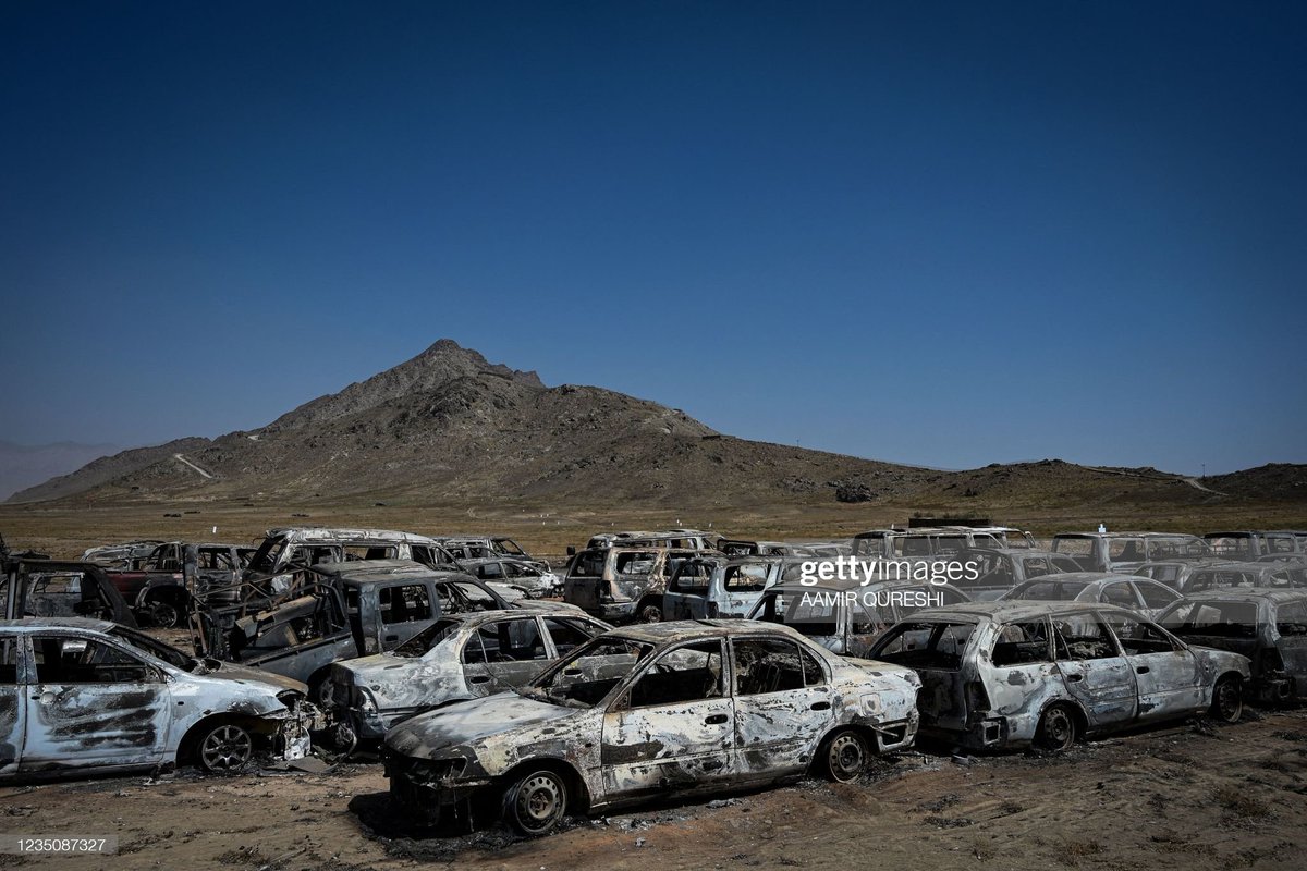
On satellite imagery, we noticed dozens of vehicles lined up inside the compound that later appear to have later been deliberately set on fire. This is is now confirmed with AFP's @aamirqureshi14's photos. (Geolocation: 34.57893, 69.29909). A satellite image from Aug. 24 captured dozens of vehicles aTOPSHOT - Damaged and discarded vehicles parked near the des
The “snooker club” inside the expanded Salt Pit facility, located at 34.57797, 69.29032 — geolocation thanks to @nabihbulos.
Here's the insightful report of TRT's @Ali_Mustafa and his team, corroborating our earlier reporting that the blown up parts of Eagle Base were an ammunitions depot and a training facility (“village”).
For at least three years, two abandoned helicopters have been present inside the compound. @Ali_Mustafa and his team filmed one of them, an Mi-17 located at 34.5837, 69.29727. The other one stands just opposite of it.

• • •

Missing some Tweet in this thread? You can try to force a refresh
 

Keep Current with Christiaan Triebert

Christiaan Triebert Profile picture

Stay in touch and get notified when new unrolls are available from this author!

Read all threads

This Thread may be Removed Anytime!

PDF

Twitter may remove this content at anytime! Save it as PDF for later use!

Try unrolling a thread yourself!

how to unroll video
  1. Follow @ThreadReaderApp to mention us!

  2. From a Twitter thread mention us with a keyword "unroll"
@threadreaderapp unroll

Practice here first or read more on our help page!

More from @trbrtc

10 Sep
NEW: Guinean Special Forces that stormed the presidential palace on Sept. 5, seizing power, were being trained by Green Berets. The U.S. military told @declanwalsh and @EricSchmittNYT it had “no prior indication” that their students were planning a coup. nytimes.com/2021/09/10/wor…
This video of two vehicles w/ men with U.S. flag patches and Guinean soldiers pushing through a crowd chanting “Freedom!” is authentic: geolocated to a roundabout south of the U.S. Embassy in Conakry and officials told @nytimes it shows their Green Berets.
The geolocation of the video was relatively straightforward. Here are some of the steps. First, the red licence plate on the Toyota matched with licence plates used for the Conakry Region (worldlicenseplates.com/world/AF_GUIN.…), suggesting the video was likely filmed in Guinea.
Read 10 tweets
9 Sep
On Sept. 11, 2001, @Maxar's IKONOS satellite was the only high-resolution commercial imagery system in orbit. As 9/11 unfolded, the collection team shifted tasking of the satellite to image the affected sites asap. Here are some of those images. blog.maxar.com/earth-intellig…
IKONOS als imaged the Pentagon on Sept. 15, 2001, showing the damage to the east side of the building. Satellite image courtesy of @Maxar.
On the left, Shanksville, Pa., where United Airlines Flight 93 crashed as seen on Sept. 13, 2001, by @Maxar's IKONOS satellite. On the right, same site nearly two decades later (it's now a national memorial).
Read 4 tweets
9 Sep
On Sept. 5, Col. Mamady Doumbouya (41) —former French legionnaire and head of the country's Special Forces Group— seized power in Guinea from President Alpha Condé (83). Threading some footage that surfaced on social media, and some geolocations. nytimes.com/2021/09/05/wor… Image
Heavy gunfire was heard in the capital Conakry on Sunday morning. This video shows the 8 Nov. Bridge connecting Camayenne and Coleah in Kaloum, the tip of the peninsula where the Presidential Palace is located.
This video shows six military vehicles and about a double dozen troops just at Ave de la Republique and Blvd de Commerce — just a block away from the President Palace.
Read 7 tweets
2 Sep
The remnants of Hurricane Ida have arrived in New York City. Threading some videos with locations.
28th St & 7 Ave subway station (Chelsea, Manhattan)
Franklin Av & Fulton St (Bedstuy, Brooklyn)
Read 28 tweets
1 Sep
The Salt Pit was so secretive that there are only a handful of on-the-ground photos of the site. I'll thread all the ones we found during our deep dive on the CIA black site here, as it may interest others too.
This photo, likely taken in 2003, is the one and only photo we found of the Salt Pit as it was operational as a CIA detention facility. It was taken by a US soldier who said he visited the site while coming or going to Bagram. Image
An interesting but by no means verified detail from that US soldier is that he claims that US folks stationed at Salt Pit told him that the former brick factory was used by Al Qaida operatives before Sept. 11, 2001. We weren't able to verify this.
Read 7 tweets
1 Sep
Our new visual investigation shows how a secretive compound northeast of Kabul — the site of the Salt Pit, where the CIA previously tortured detainees — became the agency's hub for clandestine evacuations before parts of it were deliberately destroyed: nytimes.com/2021/09/01/wor…
Also known as COBALT and “the dark prison,” Salt Pit became operational in Sept. 2002 after Langley approved $200K for construction next to an abandoned brick factory. Image shows it in 2003. By late 2004, the agency stopped using the site as a prison, official documents suggest. Space Imaging, via HO/AFP/Getty Images
The Salt Pit operated in full secrecy during those nearly two years. It was only in 2005 that the black site's existence became publicly known when @danapriest and others exposed how a detainee in CIA custody was stripped, shackled, and left to die. washingtonpost.com/wp-dyn/content…
Read 21 tweets

Did Thread Reader help you today?

Support us! We are indie developers!


This site is made by just two indie developers on a laptop doing marketing, support and development! Read more about the story.

Become a Premium Member ($3/month or $30/year) and get exclusive features!

Become Premium

Too expensive? Make a small donation by buying us coffee ($5) or help with server cost ($10)

Donate via Paypal Become our Patreon

Thank you for your support!

Follow Us on Twitter!

:(