On Sept. 5, Col. Mamady Doumbouya (41) —former French legionnaire and head of the country's Special Forces Group— seized power in Guinea from President Alpha Condé (83). Threading some footage that surfaced on social media, and some geolocations. nytimes.com/2021/09/05/wor…
Heavy gunfire was heard in the capital Conakry on Sunday morning. This video shows the 8 Nov. Bridge connecting Camayenne and Coleah in Kaloum, the tip of the peninsula where the Presidential Palace is located.
This video shows six military vehicles and about a double dozen troops just at Ave de la Republique and Blvd de Commerce — just a block away from the President Palace.
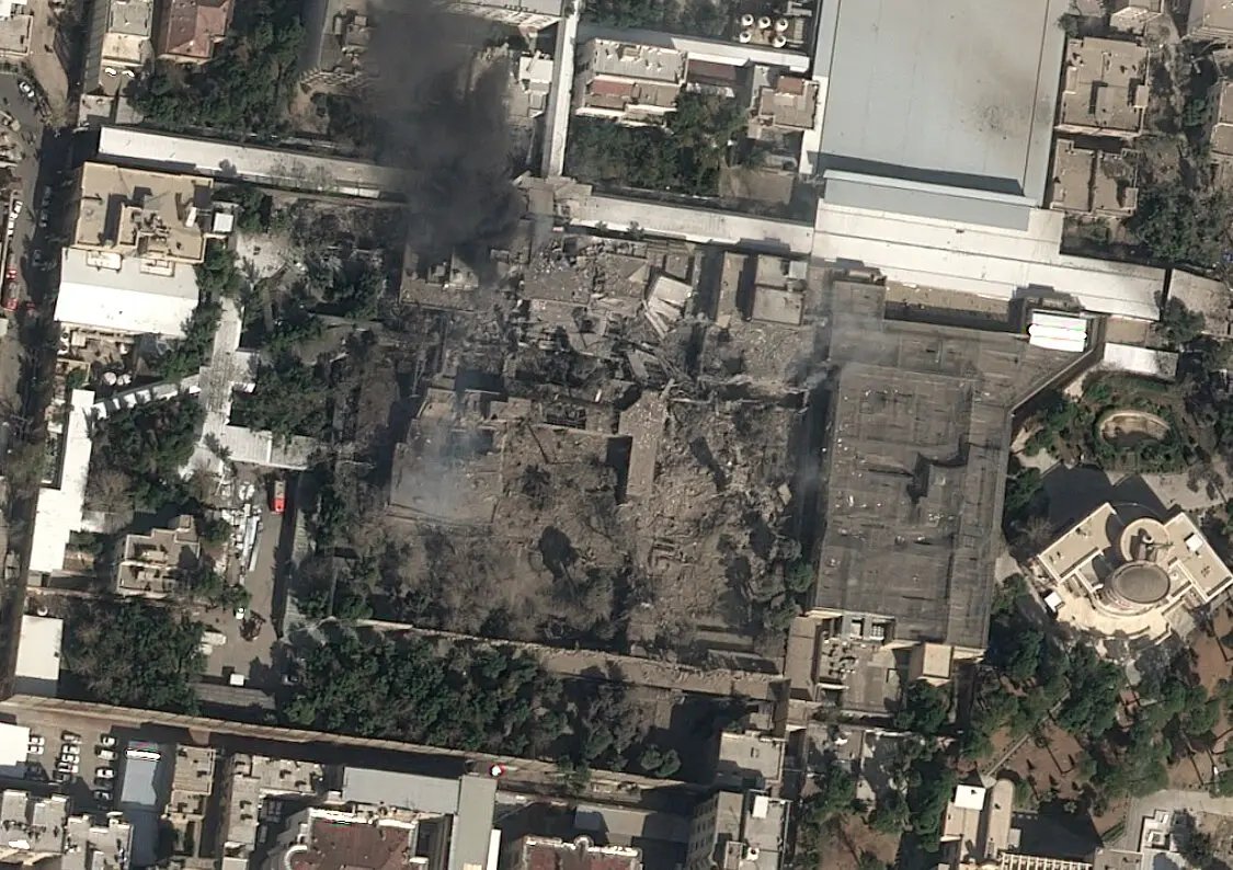
This video, already geolocated by @mafihachk, shows smoke rising very close to the Presidential Palace. The church you see is Cathedrale Sainte Marie, which is situated next to it.
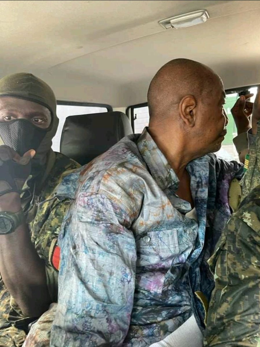
Then: photos and videos surface of Condé being held in custody by (mostly masked) men. Photos attached, and videos of those same moments:
“Finally, the head of Guinea’s special forces announced on state television that the constitution, government and all institutions were dissolved. He had staged a coup.” nytimes.com/2021/09/05/wor…
“Other videos showed Guineans taking to the streets in celebration and military vehicles moving through Conakry, accompanied by dozens of motorcycles, their riders raising fists in the air.” Lots of footage on the wires, see: nytimes.com/video/world/af…
• • •
Missing some Tweet in this thread? You can try to
force a refresh
New footage reveals an apparent U.S. or Israeli strike near a boys' school in Abyek, west of Tehran, on Feb. 28. Satellite imagery suggests a comms tower was the intended target, but flying debris killed a child on the playground. Story w/ @Parinlalala nytimes.com/2026/03/09/wor…
The footage originates from multiple security cameras. It shows an ordinary morning; boys playing on the playground. It's just hours after the first joint U.S.-Israeli strikes, so school are in session. Then, an explosion is seen at the top of the screen.
We geolocated the footage to the Imam Reza Elementary School for boys in Abyek, a small city in the Qazvin Province, west of Tehran: 36.045062, 50.542351. The footage from the interior shows the blast damaged the school itself too.
What you're looking at is not a sunrise — it's the Russian LNG tanker ARCTIC METAGAZ (IMO 9243148) struck by a massive explosion in the Mediterranean this morning. Photographed by crew aboard a merchant vessel, via Vanguard Tech.
Photos were taken ~04:00 local (03:00 UTC), looking towards Libya. ARCTIC METAGAZ had been running dark (AIS off, see @MarineTraffic screenshot) but had traveled southeast of Malta before the explosion (150NM per Maltese media, h/t @malte_humpert @sanjanamv @DefMon3).
At the time of the suspected (naval) drone attack, the ARCTIC METAGAZ was fully loaded near Murmansk with about 4 tanks of LNG, per @Kpler data. That's probably about $50 to $60 million worth in Russian gas.
We obtained the first known satellite image of Ayatollah Ali Khamenei's compound in Tehran. There are several destroyed buildings. While the current whereabouts of Iran's supreme leader are unknown, the compound is generally used as his official residence. 🛰️📸: @Airbus
*first publicly released satellite image
Either way, it goes to show that triangulating the lines of sight from four geolocated videos lead precisely to a main strike location in Tehran.
Israel has launched a daylight attack on Tehran, just now. Multiple explosions have been reported in Iran's capital. It isn't clear yet what was targeted, so starting a thread with geolocations.
This photo, showing thick smoke plumes, was taken from Hasan Abad Square (میدان حسنآباد), looking northwest. Reference photo attached (). @GeoConfirmed: 35.686144, 51.410156. google.com/maps/@35.68614…
@GeoConfirmed This video, posted by a semi-official Iranian news agency, shows thick smoke rising near Pasteur St (خیابان پاستور), where key government institutions are located. Point-of-view is southwest. Geolocation in tweet below.
The aftermath of the Jan. 8 fire in the historic bazaar of Rasht, northern Iran, is visible in satellite imagery. The image is accessible via @Soar, a relatively new free platform aggregating satellite data from multiple sources, including @CopernicusEU.
The fire broke out amid nationwide anti-government protests, and Rasht's bazaar was a focal point of unrest, including clashes and strikes by merchants. Iranian authorities blame protesters for setting the fire, eyewitnesses dispute that. factnameh.com/fa/fact-checks…
Reports from activists and social posts suggest ~300 shops were destroyed or heavily damaged. Several 19th century sarays (covered market sections) burned completely. Coordinates: 37.279829, 49.589358. Link to the @Soar platform. And h/t @x4rius. soaratlas.com/satellites?pos…
The U.S. in is in the process of seizing OLINA in the Caribbean near Trinidad, per @Reuters. It's flying a false flag of Timor Leste. It's loaded with oil cargo from Venezuela, per @Kpler and @TankerTrackers. And last known location is 12.16769, -62.6113, per @oballinger.
The tanker was hit by U.S. sanctions last year in re: Russia’s war in Ukraine. At the time, it was named MINERVA M, but it can still be identified by its IMO number, 9282479, which appears in related references. OFAC: ofac.treasury.gov/recent-actions… Reuters: reuters.com/business/energ…
A U.S. Coast Guard and Navy team has boarded and seized the vessel, per @EricSchmittNYT. nytimes.com/live/2026/01/0…