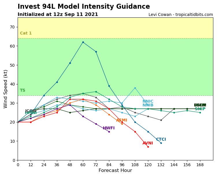
SAT PM - The GFS/EURO ensemble plots show most of the iterations for each model bringing Invest 94L north in the Western Gulf, paralleling the coastline. Most members at either Tropical Depression or Tropical Storm strength.
A track paralleling the TX/MX coast will make landfall hard to predict & won’t be a ‘tell all’. Spread could be from MX to LA. A weaker system would likely ‘spread the wealth’ of rain across a larger area. A more developed system would concentrate the highest rain totals.
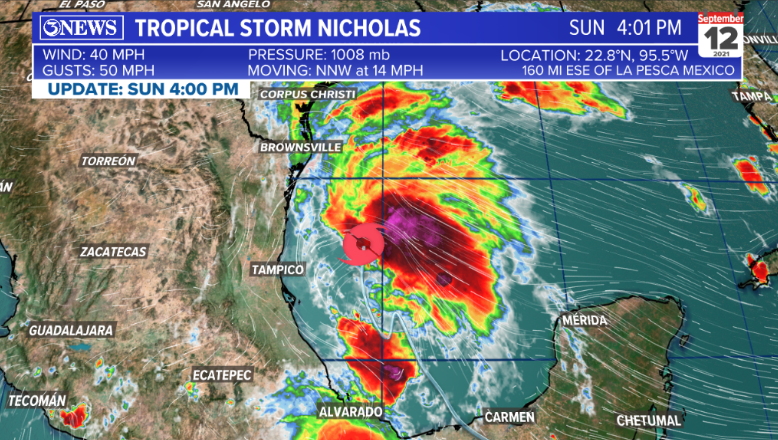
As of SAT afternoon, Invest 94L doesn’t look like a wind threat for the Coastal Bend, but depending on how this develops with respect to distance from the coast, the intensity forecast could change. A track farther away from the coastline would also lower rain chances, locally.
Still some wrinkles to iron out, for sure. Note: a strong tropical storm can still generate wind damage (39-73mph)
This system will pass into/through the Coastal Bend on Monday/Tuesday
• • •
Missing some Tweet in this thread? You can try to
force a refresh
SUN 10pm - Nicholas remains a 40 mph tropical storm, moving slowly north at 2 mph in the Western Gulf of Mexico. 1/5
There is a notable east shift in the 10PM forecast cone, which is now just to the east of Corpus Christi. Nicholas is forecast to become a 65mph tropical storm (75 mph gusts) en-route to the Middle Texas Gulf Coast TUE morning. Nicholas slows and weakens over SE TX WED/THU. 2/5
Still looking at between 3-5" in coastal areas of the Coastal Bend with totals dropping the farther inland you go. 3/5
SUN 4PM - Tropical Storm Nicholas is a 40mph storm, moving NNW at 14 mph. It's about 160 miles off of the coast of Mexico and about 200 miles south of the TX/MX border.
Nicholas will move northward, paralleling the Mexico/Texas coastline through Monday. Some strengthening is expected over the next 24-36 hours. Winds near the center of the storm forecast to reach 65 mph by Monday afternoon.
Because Nicholas is paralleling the coast, landfall could be anywhere from South Texas, to the Middle Texas Gulf Coast. Personally, the 'landfall' of this storm won't be a huge deal with respect to what impacts are felt.
Sun 10A - Tropical Storm Nicholas has formed in the Bay of Campeche. Tropical Storm warnings are posted on the Texas Gulf Coast from Brownsville to Corpus Christi. Tropical Storm watches north of that.
Nicholas will parallel the TX coastline, passing through/near The Coastal Bend on Monday evening/Tuesday morning as a strong tropical storm - 65 mph winds.
4-6” of rain with isolated higher totals in the Coastal Bend. Highest rainfall amounts will be closer to the coast. Expect rough surf, dangerous rip currents, and flooding on area beaches through Tuesday/Wednesday.
🌀🧵SAT AM - Invest 94L, the tropical wave moving into the Bay of Campeche this weekend, continues to have a high (80%) likelihood of developing over the next few days.
Most guidance keeps this feature from garnering too much strength in the Western Gulf. The consensus is at least a tropical depression; meaning a cyclonically spinning storm with winds under 39 mph.
A few notes on current intensity forecast: 1) there is some wind shear in the Bay of Campeche. That’ll mitigate strengthening for a day or so. 2) if the storm can develop farther into the gulf - away from the coastline - intensity forecasts could go up.