ALERT: NWS Reno is now predicting higher rainfall totals than any weather event in at least 20 years. Now is the time to finish clearing your gutters and drainage area, and finalize your plans to evacuate, esp if you live in or near a burn scar like the #CaldorFire. Details here:
Light to moderate rain is slowly spreading over the #CaldorFire area now and will be widespread by mid morning. Saturday may see somewhat lighter showers, with the main weather event beginning early Sun. Twin Bridges will wake up to a steady rain Sun AM, increasing in...
...intensity throughout the day. Snow levels are likely to remain above 10k ft through Sunday evening. Throughout Sun, expect heavy (possibly historic) rain below 10k, heavy snow above, gusts of 35 mph in valleys/up to 80 mph at ridges. Main threat across #CaldorFire area...
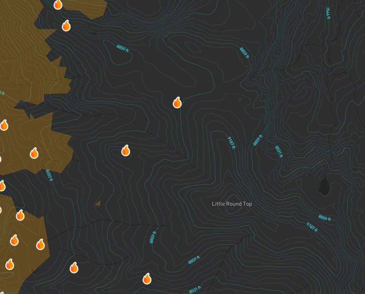
...will be fire-weakened trees falling, flash flooding (primarily smaller creeks), and debris flow across El Dorado County where burn scars are the most significant. Remember, crews working the #CaldorFire have only just begun repair work in many areas and many hazard trees...
...have yet to be brought down. Overnight into Mon AM snow levels will begin to fall, eventually to 5k feet Mon night. However, the majority of precip will already have fallen by then. Current predictions call for 2+ ft of snow above 9k, 1 ft above 7k, and...

#CaldorFire
...2-3 inches in Tahoe Basin. That said, there is model uncertainty in terms of exactly when the snow levels will come down so these numbers may be revised. Regardless, the main story across the #CaldorFire are will be the several inches of rain, particularly...
...given how fresh these burn scars are. Power outages, mud and debris flows, flash flooding, and tree falls will be a threat well into Monday night. A few quick notes before I wrap: In the next 24-48 hours many folks will be sharing weather predictions across the #CaldorFire...
...area from a variety of sources, many of whom are weather experts. All will have slight variations in storm totals and intensities until we get closer to the arrival of the main event. Personally, I will be focusing on info from @NWSReno and their discussion boards. There...
...r many other sources that are just as valid and trustworthy. Feel free to share that info here as well. Again, clean your gutters and drainages, prep ur generators (and go over safe operation), and review your evac plan JIC. Be safe and prepared, not panicked. ~J

#CaldorFire

• • •

Missing some Tweet in this thread? You can try to force a refresh
 

Keep Current with Jericho Island

Jericho Island Profile picture

Stay in touch and get notified when new unrolls are available from this author!

Read all threads

This Thread may be Removed Anytime!

PDF

Twitter may remove this content at anytime! Save it as PDF for later use!

Try unrolling a thread yourself!

how to unroll video
  1. Follow @ThreadReaderApp to mention us!

  2. From a Twitter thread mention us with a keyword "unroll"
@threadreaderapp unroll

Practice here first or read more on our help page!

More from @jerichoisland

20 Oct
Sarasota County Medical Examiner has been called to the Carlton Reserve where officers have been searching for Brian Laundrie. Earlier, Laundrie's attorney stated "articles belonging to Brian" were found in the same park.
5 minutes ago an ATV delivered a white tent to officers who then erected in an area that is heavily wooded in the Carlton Reserve.

#BrianLaundrie
Several additional unmarked vehicles are now arriving af the Caldor Reserve.
Read 12 tweets
23 Sep
Your midday #FawnFire and #CaldorFire alerts and updates thread begins here:

ALERT: Mountain Gate area, EVAC ORDER for Holiday rd S of Old Oregon.
ALERT: NE Redding, EVAC ORDER for all of Tierra Oaks. #FawnFire
ALERT: NE Redding, EVAC ORDER for all resident west of Old Oregon and N of Akrich st. Again this includes Tierra Oaks.

GO S ON OLD OREGON AND W ON OASIS RD NOW!

#FawnFire
Read 17 tweets
23 Sep
Your #CaliforniaWildfires alerts and updates thread begins here.

We will start with #CaldorFire: Winds will shift to E/NE today up to 20 mph on ridge tops.
ALERT: Additional engines and strike teams are being moved back into Christmas Valley to prepare for *possible* spot fires crossing the ridge N of Little Round Top towards the E.

#CaldorFire
ALERT: We don't yet have updated Projected Incident Activity language. As of 7:20 last night ops projected possibility of fire moving into Christmas Valley threatening up to 560 structures within 24 hours (see below). Monitoring closely for updates. #CaldorFire
Read 16 tweets
22 Sep
Your #CaliforniaWildfires alerts and updates thread begins here. We start with an important #CaldorFire alert...
#CaldorFire ALERT: As I have been reporting all day, fire has reached the ridge leading up to Little Round Top. This is confirmed on the ground and on the Leek Springs cam. @Defensible1 also is showing 2 heat indicators exactly where the Leek Springs Cam is showing plumes.
UPDATE: Just N of #CaldorFire near Smith Lake is the #SmithFire. This is a NEW start, not a spot fire. While there doesn't appear to be much fuel up here, crews are evidently concerned enough to keep a helo on it which continues to drop water.
Read 14 tweets
22 Sep
Today's #CaliforniaWildfires thread begins here:

#CaldorFire: the flareup W of Lake Margaret has grown significantly in the last 12 hours. Fire has run N of the lake into Bucks Pasture and has jumped Strawberry Creek. Several hundred additional acres have burned. Remember...
...the area burning is well inside the "alligator mouth." While spread is expected to continue, there is black to the W, N, and S, and Little Round Top to the E. No imminent threat to structures. While many refer to this as the "Kirkwood area" locals know it's well N. #CaldorFire
NOTE on Lake Margaret area: you will likely see a lot of images like the one here coming out today. Please remember folks have returned home not far from here so when you share it, please choose your words carefully and include some of the info I provided above.

#CaldorFire
Read 19 tweets
21 Sep
Your #CaliforniaWildfires alerts and updates thread begins here:

#CaldorFire Update: Hwy 50 between Kyburz and Meyers is currently opened to residents only. At 8 am the hwy is expected to reopen fully to the public.
#CaldorFire Update: while hwy 50 is reopening many areas remain without power. There is currently no update when power will be restored for Strawberry and Twin Bridges.
#CaldorFire NOTICE: Dumpsters are located at the general store in Strawberry for residents cleaning up their property.
Read 24 tweets

Did Thread Reader help you today?

Support us! We are indie developers!


This site is made by just two indie developers on a laptop doing marketing, support and development! Read more about the story.

Become a Premium Member ($3/month or $30/year) and get exclusive features!

Become Premium

Too expensive? Make a small donation by buying us coffee ($5) or help with server cost ($10)

Donate via Paypal Become our Patreon

Thank you for your support!

Follow Us on Twitter!

:(