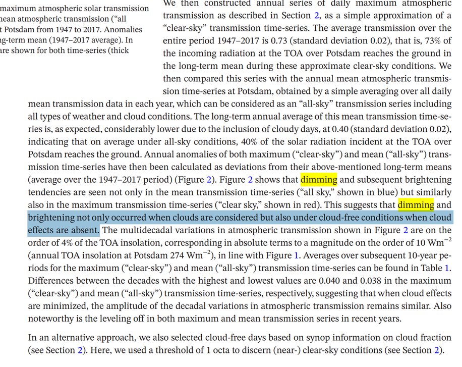
1/ #oversterfte Netherlands: The observed mortality rates from EMA Pharmacovigilance (C19 vax) look bad, but in a range that shouldn't show up in the total mortality. It would be a disaster if it did.
What we need are mortality rates by cause and age (e.g. cardiac...).
What we need are mortality rates by cause and age (e.g. cardiac...).
2/ NL 15-19 years: nothing to see, except MH17 incident 2014. 

3/ NL 20-24 years: nothing to see here, except MH17 incident 2014.

4/ NL 25-29 years: nothing to see here. MH17 incident 2014 still visible above the normal rates.

5/ NL 30-34 years: nothing to see here. MH17 incident 2014 still there.

6/ NL 35-39 years: nothing to see here.

7/ NL 40-44 years: nothing to see here.

8/ NL 45-49 years: nothing to see here.

9/ NL 50-54 years: nothing to see here.

10/ NL 55-59 years: nothing to see here.

11/ NL 60-64 years: nothing to see here. Seasonality starts to get visible in this age group.

12/ NL 65-69 years: seasonality visible. Also the sharp but short peak of the first C19 wave. But not at amplitudes that would justify a general panic.

13/ NL 70-74 years: seasonality visible. Sharp but short peak of the first C19 wave. The 2020 spring peak was higher (but shorter) than the typical flu wave. The total peak area is comparable with the 2018 flu season. The 2nd 2020 autumn wave was longer.

14/ NL 75-79 years: seasonality visible. Sharp but short peak of the first C19 wave. The 2020 spring peak was higher (but shorter) than the typical flu wave. The total peak area is comparable with the 2018 flu season. The 2nd 2020 autumn wave was longer.

15/ NL 80-84 years: seasonality visible. Sharp but short peak of the first C19 wave. The 2020 spring peak was higher (but shorter) than the typical flu wave. The total peak area is comparable with the 2018 flu season. The 2nd 2020 autumn wave was longer.

16/ NL 85-89 years: seasonality visible. Sharp but short peak of the first C19 wave. The 2020 spring peak was higher (but shorter) than the typical flu wave. The total peak area is comparable with the 2018 flu season. The 2nd 2020 autumn wave was longer.

17/ Conclusion for 2021:
1) Seasons start at different times--> little can be said now for 21/22 season.
2) The background is higher (even in the young) than any potential vax signal. It would be a disaster if vax would be visible in total mortality.
3) We need data by cause.
1) Seasons start at different times--> little can be said now for 21/22 season.
2) The background is higher (even in the young) than any potential vax signal. It would be a disaster if vax would be visible in total mortality.
3) We need data by cause.
18/ To assess any vax safety issues in detail we need:
4) mortality figures by cause, gender and age bin for the young cohorts(<65), e.g. cardiac events.
5) IC data by cause, gender and age for the young cohorts (<65) e.g. cardiac events and thrombotic events.
4) mortality figures by cause, gender and age bin for the young cohorts(<65), e.g. cardiac events.
5) IC data by cause, gender and age for the young cohorts (<65) e.g. cardiac events and thrombotic events.
• • •
Missing some Tweet in this thread? You can try to
force a refresh