Dr. Judith Hubbard Profile picture
Nov 15, 2021 7 tweets 5 min read Read on X
This is a map of sea level, exaggerated 10,000 times.

Why is it so weird and lumpy? Sea level is not defined by distance from Earth's center - it's an equal-gravity surface.

Understanding the #geoid is key to understanding #climatechange impacts. 1/7

en.wikipedia.org/wiki/Geoid Source: http://doi.org/10.5194/essd-11-647-2019.
The "lumpiness" comes from variations in density and topography. Mountains have gravity, so the #geoid is generally higher in mountainous regions. But inside the Earth there are variations, too - from the different kinds of rocks and the thickness of the crust. 2/7
Elevations on Earth are defined relative to the geoid. So every time you look at a topographic map, there's a secret geoid hidden behind that data! 3/7
The #geoid is not fixed - it changes as the balance of mass on Earth shifts. Mostly this is slow: tectonic movements, plate collision, erosion. Some of it is fast, but minor: volcanic eruptions, earthquakes.

Melting ice caps change the geoid too! 4/7

climate.nasa.gov/blog/2861/arct…
As the ice caps melt, that mass gets distributed into the oceans. This lowers the geoid near the ice caps, and makes it appear that the land is locally rising.

This doesn't work for sea ice - that ice is already floating in water, so balanced. Only ice on land matters. 5/7
This is why we can't talk about #sealevelrise with a single number: local impact depends on local geoid changes. So the weird lumpy Earth geoid - and its changes over time - are central to how coastal regions will be affected as the climate changes. 6/7

sealevel.nasa.gov/news/43/a-nasa…
If you have a 3D printer, you can print your own lumpy #geoids at home! A great stocking-stuffer if you want to confuse and offend people. 7/7

oceanservice.noaa.gov/facts/geoid.ht…

• • •

Missing some Tweet in this thread? You can try to force a refresh
 

Keep Current with Dr. Judith Hubbard

Dr. Judith Hubbard Profile picture

Stay in touch and get notified when new unrolls are available from this author!

Read all threads

This Thread may be Removed Anytime!

PDF

Twitter may remove this content at anytime! Save it as PDF for later use!

Try unrolling a thread yourself!

how to unroll video
  1. Follow @ThreadReaderApp to mention us!

  2. From a Twitter thread mention us with a keyword "unroll"
@threadreaderapp unroll

Practice here first or read more on our help page!

More from @JudithGeology

Oct 17, 2023
BSSA just published a paper where the authors claim to predict earthquakes days in advance, using AI. A quick read-through raises many question.

Does anybody know about this study and why BSSA is publishing AI/earthquake prediction papers now?

1/

doi.org/10.1785/012023…
Although the paper is framed around "earthquake forecasting," it's a prediction paper. They use the word prediction in both the paper and the supplement.

2/
This was reviewed through BSSA, and is being promoted by SSA.
Earthquake prediction, if it were proved, would be a BIG DEAL. The bar for passing review should be very high.

3/

Read 5 tweets
Mar 29, 2023
Today's M4.7 earthquake in Italy likely occurred on an east-west strike-slip fault that previously produced a pair of ~M5.8 earthquakes in 2002.

The 2002 earthquakes were horrible; fortunately today's event was much smaller.

1/

earthquake.usgs.gov/earthquakes/ev…
The 2002 Molise earthquakes occurred within ~1 day of each other (Oct 31 and Nov 1). The first quake collapsed a school, killing half the children inside (26 of 51). At the time, the area was considered to have no seismic hazard.

2/

en.wikipedia.org/wiki/2002_Moli…
The school was built with reinforced concrete, but the second floor was added later, and it is possible that this made the building more susceptible to collapse.

3/
Read 9 tweets
Mar 28, 2023
Several people have asked me recently about whether we should expect a large earthquake on the Afrin fault, south of the Feb 6 rupture.

First: no one can predict earthquakes, so if anyone has told you they can, they are wrong.

But let's take a look anyway.

1/
First, what is the Afrin fault? The AFEAD dataset has a small fault listed under this name, running through the city of Kilis, Turkey. An extension of this fault is mapped near the city of Afrin, Syria.

These faults are part of the northern end of the Dead Sea Fault.

2/
You can explore these faults yourself. The dataset describes the "Afrin fault" as having a slip rate of <1 mm/yr - i.e., not really detectable. But the extensions are a bit faster, maybe up to 5 mm/yr. The Dead Sea Fault slips ~5 mm/yr.

3/

neotec.ginras.ru/index/mapbox/d…
Read 14 tweets
Mar 28, 2023
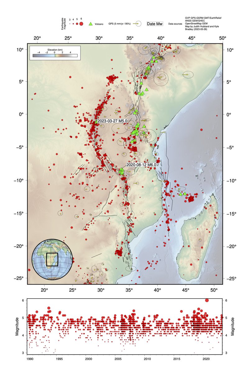
Why did a M5 earthquake occur HERE yesterday, in what is apparently the middle of the African Plate?

Answer: It's not the middle of the African Plate, it's the East African Rift: the continent is pulling apart at a rate of ~1-5 mm/yr.

1/
Yesterday's earthquake was just the latest in a long series of earthquakes - and not the largest, either; there was a M6 in 2020 to the south.

The "rift" isn't a single fault, but many.

2/
Volcanoes are scattered along the rift, too. As the crust thins, deeper areas experience lower stress, allowing "decompression melting" - hot rocks kept in a solid state by pressure will melt if that pressure is released.

3/

nature.com/articles/s4146…
Read 8 tweets
Mar 28, 2023
A M6 earthquake occurred a few hours ago offshore Japan. Due to its magnitude & distance from shore, it was not damaging, but the setting is interesting to explore.

1/
This is a subduction zone: the Pacific Plate is subducting below the Okhotsk Plate at a rate of ~9 cm/yr. The Okhotsk Plate used to be considered part of the North American Plate (even though it's in Japan!) but it actually moves slightly differently.

2/

en.wikipedia.org/wiki/Okhotsk_P…
This is a very active place, seismically speaking. Today's earthquake occurred on the subduction interface fault (called a "megathrust" - i.e. a really big thrust fault). That megathrust has hosted many large earthquakes, including...

3/
Read 17 tweets
Mar 27, 2023
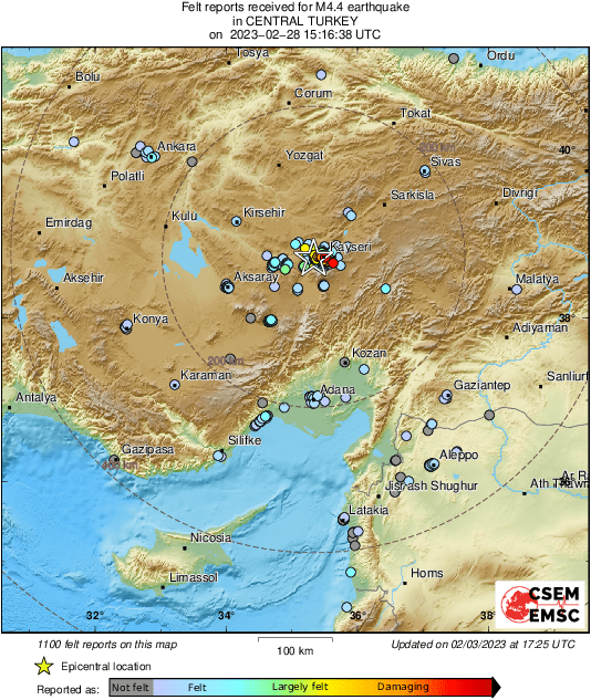
A lot of earthquakes have one large event followed by aftershocks.

But sometimes, we see something like this instead: a set of several similar-magnitude events (with additional small seismicity).

That's what has been happening near Kayseri, Turkey.

1/
It started on Feb. 23, with a M3.8. Then, a few days later, a little microseismicity.

Then, suddenly, a M4.6 on Feb. 28.

(EMSC reports it as an mb4.4, which here is converted to Mw4.6 - different ways of measuring magnitude.)

2/
People in the area, already spooked by the Feb. 6 Turkey-Syria events to the SE (which were felt here), reported shaking of intensity 4-5.

That's similar to what they felt on Feb. 6 - even though the earthquake was much smaller, it was much closer.

3/
Read 12 tweets

Did Thread Reader help you today?

Support us! We are indie developers!


This site is made by just two indie developers on a laptop doing marketing, support and development! Read more about the story.

Become a Premium Member ($3/month or $30/year) and get exclusive features!

Become Premium

Don't want to be a Premium member but still want to support us?

Make a small donation by buying us coffee ($5) or help with server cost ($10)

Donate via Paypal

Or Donate anonymously using crypto!

Ethereum

0xfe58350B80634f60Fa6Dc149a72b4DFbc17D341E copy

Bitcoin

3ATGMxNzCUFzxpMCHL5sWSt4DVtS8UqXpi copy

Thank you for your support!

Follow Us!

:(