
#ArabianStorms Update Thread:
A snapshot of the storms over the Middle East at their peak last night. The larger area of storms (as identified by weather radar) near the Gulf is the size of Germany. The smaller one over Mecca is twice the size of Switzerland.
A snapshot of the storms over the Middle East at their peak last night. The larger area of storms (as identified by weather radar) near the Gulf is the size of Germany. The smaller one over Mecca is twice the size of Switzerland.

Here's a video of some of that rain falling last night.
https://twitter.com/Arab_Storms/status/1476094880988508161?s=20
This animation shows the Gulf Coast end of the storm over night. The rain will have been continuous but radar data flow to @Zoom_Earth appears to be patchy.
This image shows the full extent of the rain as measured by @Meteoblue at 6pm last night. The blank patches with sharp edges are also data errors.
This area of storm rainfall appears to have been close to twice the size of Turkey at its height, covering most of Iraq.
This area of storm rainfall appears to have been close to twice the size of Turkey at its height, covering most of Iraq.


I have noted earlier in this series on this unusual #DesertRain event that rain forecasts for this region tend to significantly under forecast the size and intensity of rain events.
This shows a 24 hour view of the rain/storm activity in Saudi Arabia adjacent to the red sea coast. Medina and Makkah both received significant heavy rainfall.
And (as mentioned above) the storm will not have stopped and started as indicated in the radar data feed.
And (as mentioned above) the storm will not have stopped and started as indicated in the radar data feed.
Rain intensity may have reduced during the day though. So far we are definitely seeing the most intense falls during the night. Here we see views at 1am, 3am and 7am. Forecasts indicated that the heaviest rains are expected along the Iran-Iraq Border and the Iranian Gulf coast.


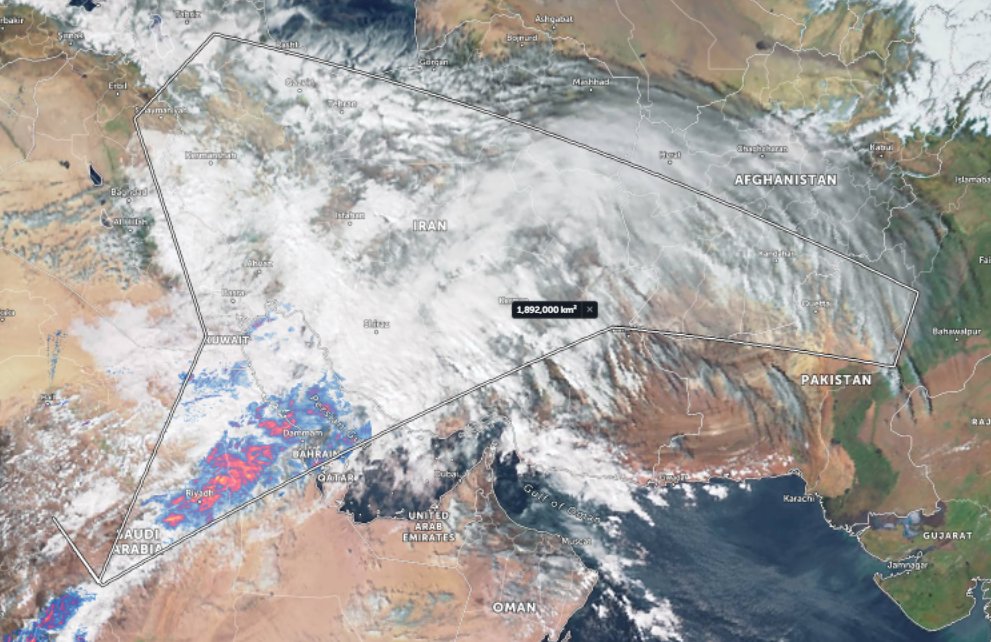
Again here is a rough measurement of the area which appears to have received rain last night. 1.8 million km2.
Actual weather observations a fairly hard to come by unfortunately - if you are aware of a good source for rainfall data please let me know.
This Kuwait twitter account does provide hourly readings. Rain is falling at roughly 4mm an hour their now. twitter.com/KuwaitMet
This Kuwait twitter account does provide hourly readings. Rain is falling at roughly 4mm an hour their now. twitter.com/KuwaitMet

Here is a 72 hour (3 day) water vapour transport forecast. In which the big news appears to be headed south from Europe towards Egypt's. This brings cold dry air with it which will keep the rain coming in phase 2 of this event through to January 4th.
Here is the forecast for phase two as posted on Christmas Eve.
https://twitter.com/althecat/status/1474428824070803467?s=20
And here is an update - again showing the forecast through to January 4th.. The key difference is that the storm coming in from the north is significantly stronger than forecast, carrying more water and energy than originally forecast.
Cairo receives lots of rain in this update.
Cairo receives lots of rain in this update.
And here we see an updated rain forecast for the same period.
As the original forecast (Dec 24 - quoted tweet) showed little rain in the first week the comparison is close but not precise.
As the original forecast (Dec 24 - quoted tweet) showed little rain in the first week the comparison is close but not precise.
https://twitter.com/althecat/status/1474434833355091970?s=20
This view of the phenomena compares what we are seeing with climate norms from 1981-2010. As i have said before, while we have had some interesting, spectacular monsoon bursts this year over Arabia, there has been nothing remotely like this.
These four plots show us what the GFS weather model is currently predicting to be the situation on January14th.
1. PWAT Anom
2. PWAT Raw
3. Water Transport (includes MSLP)
4. Accumulated Rain.
1. PWAT Anom
2. PWAT Raw
3. Water Transport (includes MSLP)
4. Accumulated Rain.


الله أعلم
/ENDS
@Threadreaderapp unroll
@Threadreaderapp unroll
• • •
Missing some Tweet in this thread? You can try to
force a refresh


