In-depth-- why Monday's snowstorm was so severe: wapo.st/3ERXyTF ... Thread follows...
The impact of Monday's storm can really be tied to:
1) its intensity and track, perfect for walloping central Va, S Md and DC with high snowfall rates and wind
2) the heavy, wet nature of the snow, which caused thousands of tree limbs to snap
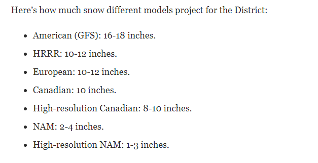
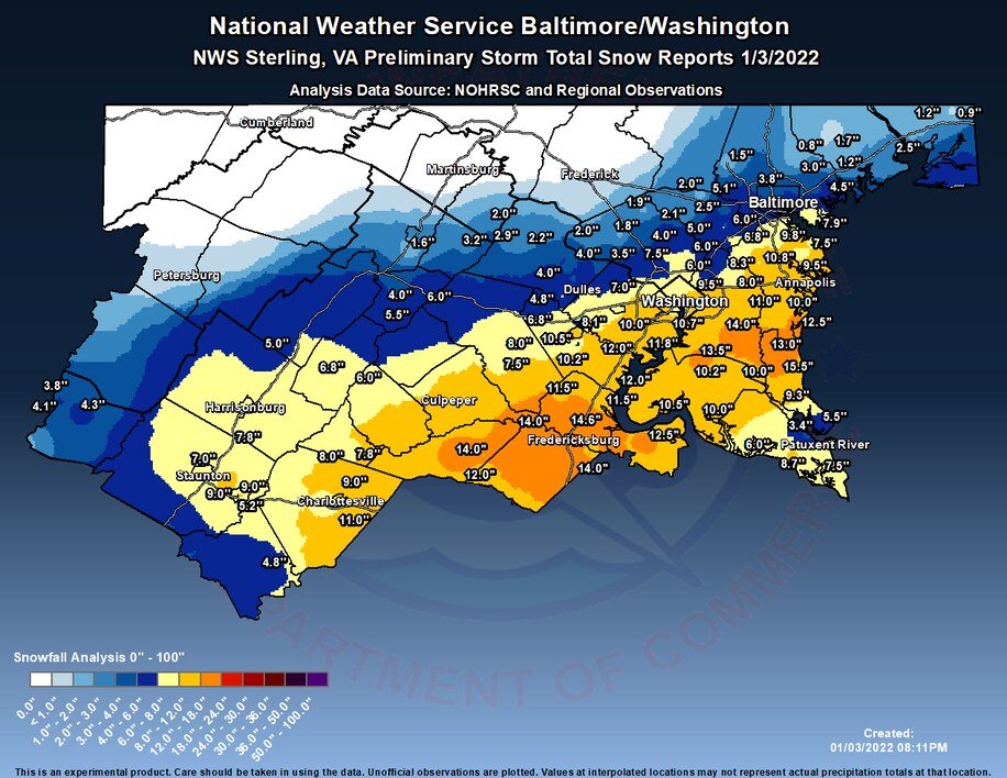
Here's how much snow fell...but it wasn't the amount of snow that fell that made this storm so bad, but how quickly it fell -- at 1-3" per hour for several hours from DC south.
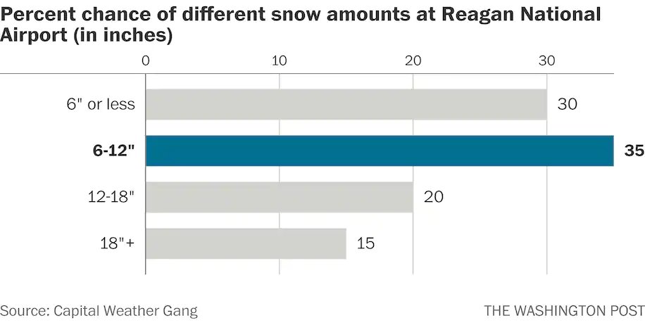
Snowfall in DC (6.9") was notable on several counts:
* Record for Jan. 3
* More snow than fell in last two winters combined
* Most in 1 day in ~3 years
* Most on record the day after 63+ degrees
* 3rd biggest first snow of season on record
(Last 2 stats per @islivingston)
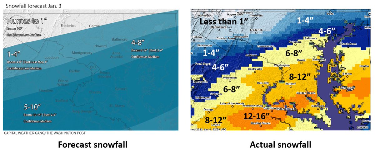
How was our forecast? Our map got northern half of area right but was too conservative in southern half. Yes, we warned of heavy snow and dangerous travel, but didn't anticipate the outages. Also, event snuck up on us-- only 1 day of lead time. Overall, mixed performance.

• • •

Missing some Tweet in this thread? You can try to force a refresh
 

Keep Current with Capital Weather Gang

Capital Weather Gang Profile picture

Stay in touch and get notified when new unrolls are available from this author!

Read all threads

This Thread may be Removed Anytime!

PDF

Twitter may remove this content at anytime! Save it as PDF for later use!

Try unrolling a thread yourself!

how to unroll video
  1. Follow @ThreadReaderApp to mention us!

  2. From a Twitter thread mention us with a keyword "unroll"
@threadreaderapp unroll

Practice here first or read more on our help page!

More from @capitalweather

2 Jan
CWG's detailed outlook for Monday snow event... These amounts * could * be conservative. Thread to follow... wapo.st/3pK9B15
As usual, very challenging forecast as there will be sharp cutoff in heavy snow...probably somewhere between Beltway and northern Maryland. Model forecast for DC range from 1-2 inches on low end and over a foot on high end. We're taking middle ground. Image
Yes, some reliable models are showing double digit totals in DC area... but keep in mind these models wrongly assume all snow that falls will stick and sometimes overdo amounts...so we have to adjust for that. Here is the raw, unadjusted model forecasts: Image
Read 4 tweets
1 Dec 21
Exceptional warmth spreading into the Central U.S. with some places seeing temperatures 30-35 degrees above normal Wednesday and Thursday: wapo.st/3lpySuV 1/x
Dozens of record highs are set to be broken the next two afternoons. Many parts of the central U.S. seeing highs well into the 60s and 70s. 2/x
Where's the snow? There's hardly any of it. Just 10 percent of nation has snow cover, second lowest on record for Dec. 1 (since 2003). Mountain snowpack is well below normal over most of West. 3/x
Read 5 tweets
10 Nov 21
DC winter outlook THREAD: First, let's share our snowfall map--these are our predicted amounts for the ENTIRE winter. While not particularly impressive, they would beat last winter's totals: 1/x
An important note on the snowfall forecast: While we're predicting below-average amounts for the 5th time in the past 6 winters, it would just take one blockbuster storm to surpass it. The thing is though, La Ninas - which we have this year - lower the odds of a big snow. 2/x
During La Ninas, winter storms tend to track to our west, drawing in mild air from the south. So we can get some snow, but usually in modest amounts before it changes to ice and rain. 3/x
Read 6 tweets
9 Nov 21
Powerful storm off Pac Northwest coast (yes, another bomb cyclone) has driven heavy rain, mountain snow into northern Calif to Washington. It's also catalyst for storm that will develop in Plains with snow/high winds in Dakotas, N Minnesota late week. wapo.st/3khWqRF 1/x
Pacific Northwest really getting hammered with precipiation--this is very typical of La Ninas. Map here is forecast precip through Friday morning: 2/x
As storm develops in northern Plains/Upper Midwest, heavy snow and strong winds likely to be big issue for northeast North Dakota and northern Minnesota, Thursday night and Friday - specific amounts still coming into focus. La Nina also favors harsh winter in this area: 3/x
Read 4 tweets
15 Oct 21
The warm weather has been holding back fall colors in the Mid-Atlantic; you have to head high into the mountains to see much. BUT... cooler temperatures inbound should help to move colors along in the next week: wapo.st/3j5n3c9
Generally the best color right now is 2-3+ hours west of DC, at elevations above 2,000 feet... like right here:
Garrett County in western Maryland is also showing near-peak color:
Read 4 tweets
15 Oct 21
Who's ready for the return of fall-like weather? This graphic shows the predicted 24 hour temperature change Saturday into Sunday. Here's our article on the big transition: wapo.st/2XgGdUN (1/x)
Along the big cold front coming east, there is an elevated chance of strong to severe storms, today in the Tennessee and Ohio Valleys and in the Mid-Atlantic and Northeast Saturday. (2/x)
Got outdoor plans Saturday afternoon around Richmond/DC/Baltimore/Philly? Be prepared for an interruption. Gusty showers/storms probable mid-late-afternoon. Shouldn't last long. (3/x)
Read 4 tweets

Did Thread Reader help you today?

Support us! We are indie developers!


This site is made by just two indie developers on a laptop doing marketing, support and development! Read more about the story.

Become a Premium Member ($3/month or $30/year) and get exclusive features!

Become Premium

Too expensive? Make a small donation by buying us coffee ($5) or help with server cost ($10)

Donate via Paypal

Or Donate anonymously using crypto!

Ethereum

0xfe58350B80634f60Fa6Dc149a72b4DFbc17D341E copy

Bitcoin

3ATGMxNzCUFzxpMCHL5sWSt4DVtS8UqXpi copy

Thank you for your support!

Follow Us on Twitter!

:(