
#EUROPE #ExtremeWeather
Forecast models show the period of relative quiet in terms of tropical atmospheric river activity in the North Atlantic has come to an end, and the next fortnight will bring significant rain and snow across most of Europe and the Mediterranean.
Forecast models show the period of relative quiet in terms of tropical atmospheric river activity in the North Atlantic has come to an end, and the next fortnight will bring significant rain and snow across most of Europe and the Mediterranean.
The forecast above shows the next 8 days of precipitable water as forecast by the @NOAA GFS model. The combination of this atmospheric water and a stationary high pressure system in the North Atlantic create conditions for very high levels of precipitation.
Days 8-16 days below.
Days 8-16 days below.
Both 8 day periods include an interesting new feature, caused by significant levels of convection off the West Coast of the North Africa. This is a 24 hour satellite loop of the first of these events currently underway.
This wider angle view of the the Northern part of the Western Hemisphere shows us two flows of water over North America from the Pacific (one over Canada, one over Mexico) are augmenting the quantities of water in the North Atlantic.
This IVT (Integrated ater Vapour Transport) plot shows the dynamics which give rise to a continuous high level of water transport into the North Atlantic and then south over the UK into Europe over the next 8 days.
Shifting our view further East now centered over Europe we can see the consequences through to the end of January.
The second burst of water and energy is due to pass over Scotland on the 28th and 29th of January.
These two forecasts show 10 day snowfall for the UK and Scandinavia. But the heaviest falls will be during this initial phase from the look of things.
These two forecasts show 10 day snowfall for the UK and Scandinavia. But the heaviest falls will be during this initial phase from the look of things.


The continued presence of the high pressure system over the North Atlantic moving slowly eastwards provides guidance through the next 8 days in the current forecast. Continuing to curl streams of water over the UK...
This pattern is not new & has been seen in various forms through Jan., contributing to intense rain events, incl. flooding in France & storms and other #extremeweather events in the Eastern Med. including significant rainfall in the Levant.
Current 16-day forecasts below.
Current 16-day forecasts below.


The next two PWAT Anomaly animations provide a perspective on #climatechange attribution to this weather. The first is for 16 days from the GFS Model.
And this 10 day forecast is from the European ECMWF model.
In terms of impact the combination of tropical warm atmospheric rivers and cold winter temperatures results in rainfall and the next three plots address that in three ways. This first one shows accumulating total precipitation over 16 days.
But as it is winter this precipitation will fall as both rain and snow. This forecast shows snow depth over the 16 day periods, and it is apparent from the advancing and retreating snow that temperatures will fluctuate significantly over the 16 days.
The GFS (US) and ECMWF (EURO) forecasts for snow depth vary significantly as can be seen in this sub-thread about this event for Ukraine posted earlier.
As precipitation forecasting is difficult all these forecasts should be taken as indicative only.
As precipitation forecasting is difficult all these forecasts should be taken as indicative only.
https://twitter.com/althecat/status/1485613982094610439?s=20
The final impact animation in this thread shows K-Index - a measurement of extreme weather/atmospheric instability which is associated with thunder storms.
This forecast indicates that thunderstorms (extreme precipitation events) can be expected during this period.
This forecast indicates that thunderstorms (extreme precipitation events) can be expected during this period.
Additional country specific 10-day snowfall forecasts:
1. Romania
2. Germany
3. Belarus
4. Poland.
1. Romania
2. Germany
3. Belarus
4. Poland.


5. Switzerland
6. Italy & Adriatic Coast
7. Austria
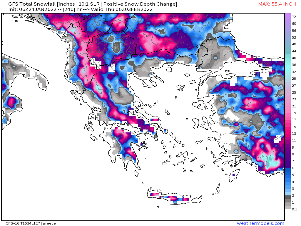
8. Greece.
6. Italy & Adriatic Coast
7. Austria
8. Greece.


9.France
10. Central Europe
11. Turkey
12. Western Mediterranean
10. Central Europe
11. Turkey
12. Western Mediterranean


And finally Europe as a whole (16 days total snowfall).

Note the maximum forecast snowfall in this final picture = 4.7m / 15 feet.
Which will presumably be somewhere in Norway on a mountain.
Which will presumably be somewhere in Norway on a mountain.

/ENDS
@Threadreaderapp unroll
@Threadreaderapp unroll
• • •
Missing some Tweet in this thread? You can try to
force a refresh


