Today we decided to find the Matilda Hospital Artillery Observation Post. Starting from Wah Fu Estate, our journey began with an abandoned squatter village, completely hidden from view next to a major thoroughfare. 

Raised platforms, bits of tile and hand-poured concrete stairs are all that remains. Maps from the 1970's already list the area as containing ruins so perhaps they were resettled in Wah Fu Estate - but artifacts from the 80's suggest otherwise.


Darlie had the name changed in 1989, while cassette and VHS tapes also point to late 80's or early 90's. Unfortunately there were no markings on the tapes.


As usual, somebody has set up a small garden for themselves, with DIY structures and even a DIY shrine! The steps continue further up the hill, but red string has been strung across it and it looks like it's overgrown further up. Time to go back to the main path.


The "correct path" staircase built by the government winds its way past more terraces built by the squatters (or possibly the Dairy Farm but we don't think their lands extended this far south).


Here's a find from 1974 - #Staffordshire blue flower power cups! @teee_el may have more information. Currently going for £4 each so we may want to come back in another century or two to increase the resale value.


Living in a squatter hut did not dampen the desire for a better life, and a nice-looking pair of shoes could raise the spirits.


These villages had power and telephone connections. It was safer to allow access rather than have inhabitants illegally and dangerously split wires to get electricity. Nice to see a Made in #Hongkong stamp!


There's a fair amount of other industrial rubbish. This is either a hair dryer or an electric drill, while a rusted refrigerator lays where it tumbled decades ago.


A child's prize possession. I wonder where they are now?

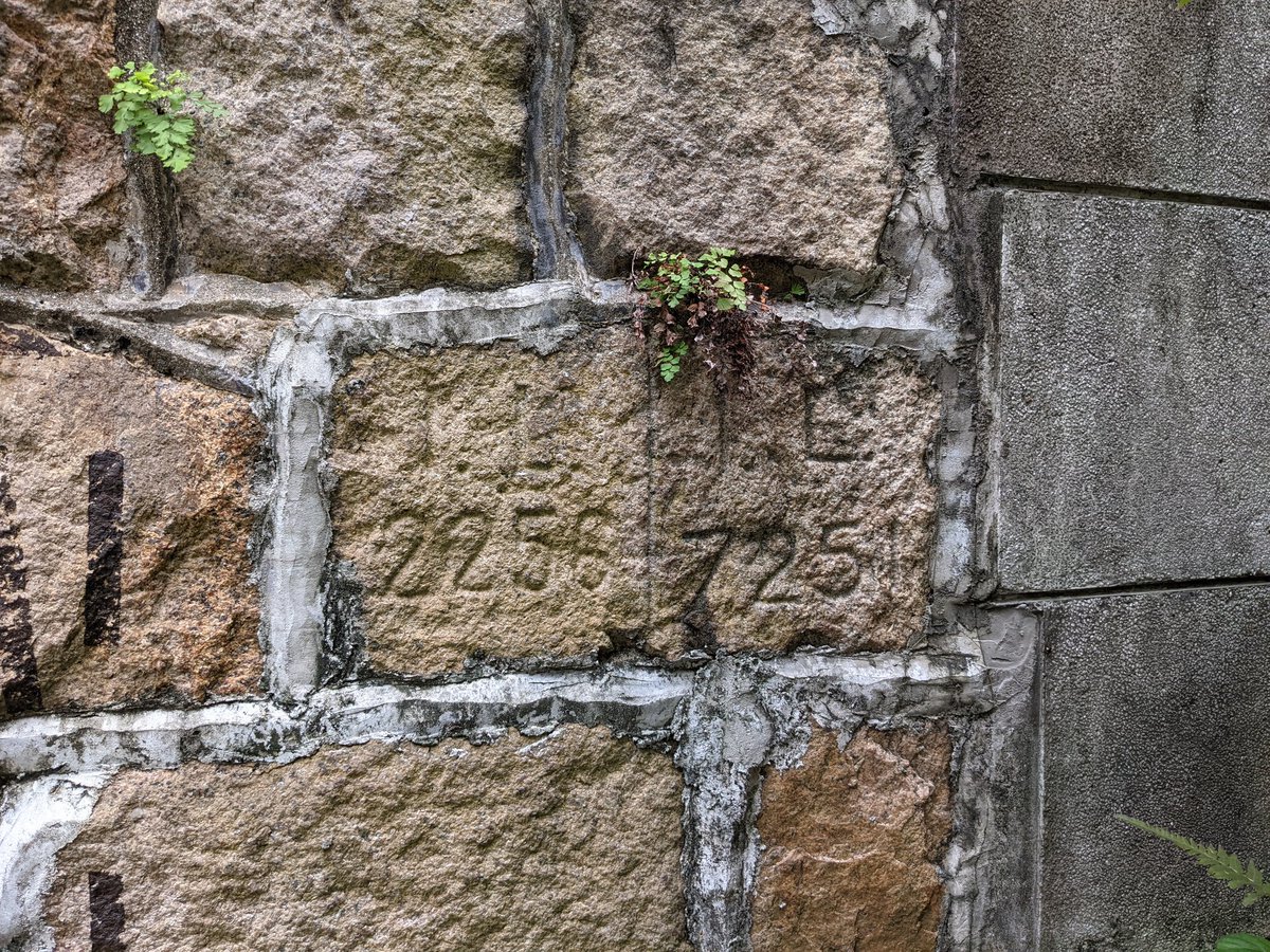
Heading further up the path, we find a property allotment marker stone! If that's IL, it stands for Island Lot. Odd to have it all the way up here though. Nearby is a DIY garden, so the pebble walking trail isn't taped off to "prevent Covid".


Just off the trail is an odd trench and concrete-lined pit! If this was Dairy Farm land, it would explain the need for the property demarcation marker below.


From here, we can see Tin Wan and the Aberdeen Cemetery in the foreground, with Ap Lei Chau in the background. The Aberdeen Battery fort is on the green hill in the middle.

Heading further up, at about 268 metres elevation we find that a hill fire has removed much of the undergrowth, revealing what looks to be an open grave! The rectangular hole is about 1.5 metres deep, and there's no indication of why it might be here.


At 343 metres up, an odd concrete shape in the jungle caught our eyes. Looks like some kind of pump or controller for Drainage Services, judging by the iron parts at the bottom. DSD was formed in 1989 so it can't be that old, but why is it in the middle of nowhere?


Finally, we reach our goal - the Matilda Hospital Artillery Observation Post! As interest in #Hongkong history has grown, other explorers are cleaning up our historic sites. Many of the trees overgrowing the structure have been removed.

In the bottom left, you can just barely see a box-like concrete structure. This was the telephone junction box, and the line from the observation post to Admiralty would have gone through here. The iron bands which would have held the wires in place are still here!


From the inside, the two viewports give a strategic point from which to observe movements threatening Aberdeen, though the protective shutters have been long since removed. Keep in mind that the hills would have been devoid of trees and other vegetation.


Let's have a little look around.
The air vent is unobstructed, and the metal fasteners where the crew's beds would have been are still in the walls. The isolated location of this AOP helped ensure it stayed in better condition than other sites.


All right, here's the best part. For whatever reason, the original doorway to the AOP was bricked up and and a hole ripped out from the back wall into a Japanese tunnel. One theory is that the tunnel was originally totally concealed, allowing a secret escape.


Let's go in! Sorry about the lighting, had to use the phone torch! Turned back when we realised we were annoying some very sleepy bats.
Behind the AOP are British trenches. A similar system is found at the Jardine's Lookout AOP.


Finally, after much scrambling along a last slope, we finally emerge just outside the Matilda Hospital. Large signs warning of trespassers being prosecuted surely don't refer to us!


As we begin the walk along quiet Mount Kellet Road towards transport home, something catches our eye - an RBL (Rural Building Lot) property marker stone! Although home to the mega-rich now, in the 1800's the south side of the Peak was considered "countryside".

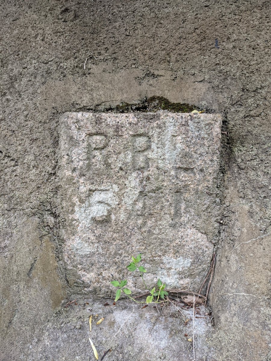
I mean, you wouldn't expect such a humble-sounding road name to exist in one of Hong Kong's wealthiest districts, but things were different in 1876. Nearby Plantation Road is named for the former farm. That's all for this month, and thank you for reading.

• • •
Missing some Tweet in this thread? You can try to
force a refresh