
#ExtremeWeather Update Thread: Madagascar #Invest96S
The JTWC is now saying there is a "High" probability of #Invest96S will become a TC within the next 24 hours.
The JTWC @USNavy @USNRL website [Here: metoc.navy.mil/jtwc/jtwc.html] remains inaccessible.
The JTWC is now saying there is a "High" probability of #Invest96S will become a TC within the next 24 hours.
The JTWC @USNavy @USNRL website [Here: metoc.navy.mil/jtwc/jtwc.html] remains inaccessible.

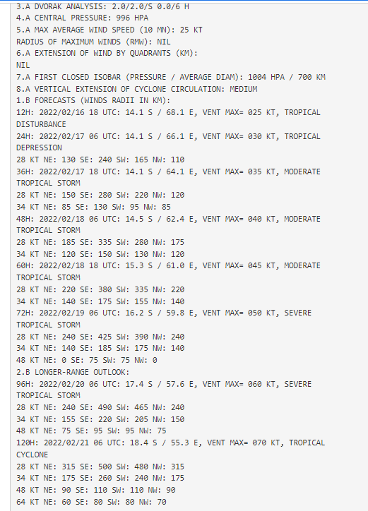
@USNavy @USNRL While we do not have a JTWC track forecast yet, we do have a new forecast. the relevant part for #96s is in the 2nd image here and contains reasoning as to why:
"THE POTENTIAL FOR THE DEVELOPMENT OF A SIGNIFICANT TROPICAL CYCLONE WITHIN THE NEXT 24 HOURS IS UPGRADED TO HIGH."
"THE POTENTIAL FOR THE DEVELOPMENT OF A SIGNIFICANT TROPICAL CYCLONE WITHIN THE NEXT 24 HOURS IS UPGRADED TO HIGH."


Here's a current 24h animation of the storm, at the end you see the center of circulation is fully exposed. The storm is moving fairly fast and is being blown westwards by winds which are creating a lot of shear - which prevents development.
This 6hr animation shows the exposed area of circulation more clearly. The storm is moving West at around 8 knots.
Overnight there was a lot of convection, the storm developed a long tail feature, which is holding it back. A repeat of last night.
Overnight there was a lot of convection, the storm developed a long tail feature, which is holding it back. A repeat of last night.
https://twitter.com/Sausius_wx/status/1493667059967963136?s=20&t=GkPkrKLtqXzYoNgBaXLHJg
Yesterday the tail's moisture collapsed spectacularly back into the main area of circulation, it will be interesting to see if this happens again.
https://twitter.com/althecat/status/1493615134098472967?s=20&t=GkPkrKLtqXzYoNgBaXLHJg
The main challenge the storm has at the moment is shear which is increasing. To my untrained eye this graphic overlay from CMISS suggests that there might still be two areas of circulation here - one exposed, one not. But moments later the shear map overlay has changed.


This graphic overlay provides a far more easy to understand picture of what is happening.
The coloured blobs are water vapour, and indeed it is moving from the tail into the eye, also outwards as outflow. Most usefully we have a guide to the center of rotation.
The coloured blobs are water vapour, and indeed it is moving from the tail into the eye, also outwards as outflow. Most usefully we have a guide to the center of rotation.
Here's the full legend for the image above:
Overlay Products
- Latitude/Longitude
- Invest Position
20220216/0600UTC
(source:JTWC)
- CIMSS Env Steering Product
500-850hPa layer
for TC MSLP range 990-999hPa
Valid:20220216/0600UTC
Overlay Products
- Latitude/Longitude
- Invest Position
20220216/0600UTC
(source:JTWC)
- CIMSS Env Steering Product
500-850hPa layer
for TC MSLP range 990-999hPa
Valid:20220216/0600UTC

Finally here's another more traditional animation from CMISS of this which shows the roughly the same features, albeit not quite as clearly.
These two images read together graphically show why the storm is expected to strengthen. The track here is from cyclocane.com/5-storm-tracke… and shows the RMSC forecast track from @MeteoFrance La Reunion (the island you can see south of the final track point.


According to the latest track forecast (2nd image contains the coordinates - helpfully plotted automatically by Cyclocane cyclocane.com/5-storm-tracke…)
You can see that the storm is expected to move South West into a lower shear environment - where it is expected to strengthen.
You can see that the storm is expected to move South West into a lower shear environment - where it is expected to strengthen.

"THE FAIRLY RAPID MOVEMENT IN THE DIRECTION OF WIND SHEAR, GOOD LOW LEVEL CONVERGENCE, AN EXCELLENT OCEANIC POTENTIAL... SHOULD ALLOW GRADUAL INTENSIFICATION... POTENTIALLY UP TO THE STAGE OF SEVERE TROPICAL STORM OR TROPICAL CYCLONE FROM THIS WEEKEND."

So in conclusion: By the weekend there is a "High Probability" Tropical Disturbance 5/a.k.a #Invest963 will become a Tropical Cyclone. The current track suggests it will be located north of La Reunion - but this may change.
Tropical Storm forecasts are limited to 5 days as beyond 3 days accuracy of track/intensity forecasts statistically falls steeply. But "numerical models" are running continuous simulations and these provide a guide beyond that.
One public source is >> cyclocane.com/5-spaghetti-mo…
One public source is >> cyclocane.com/5-spaghetti-mo…


[Disclaimer: All predictions of what may happen beyond 3 days are subject to likely change.]
At this stage the models are forecasting landfall on Tuesday 22nd Feb. The storm's path looks like it will be very similar to #Batsirai and at similar intensity.
At this stage the models are forecasting landfall on Tuesday 22nd Feb. The storm's path looks like it will be very similar to #Batsirai and at similar intensity.
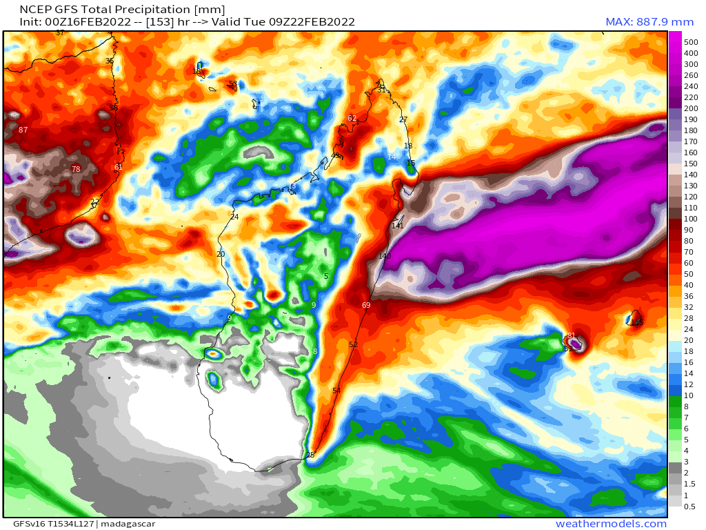
The latest GFS simulation shows extreme rainfall at rates of around 20mm per hour. Cyclone force winds up to 160kmh are forecast to cause storm surge and coastal inundation. Wind and rain will be capable of destroying buildings already damaged by #batsiraicyclone


And total forecast rainfalls could cause floods similar to #Batsirai in the same places.
The latest ECMWF and GFS models are in broad agreement at present.
The latest ECMWF and GFS models are in broad agreement at present.


And for these reasons preparations for worst case scenarios are warranted. Even though the storm has not formed, and its track may be significantly different than forecast.
Prayers are indicated.
Prayers are indicated.
/ENDS
@threadreaderapp unroll
@threadreaderapp unroll
• • •
Missing some Tweet in this thread? You can try to
force a refresh


