
"Indiscriminate shelling of Donetsk on 04 JUN",
@GeoConfirmed thread 5.
Who shelled Donetsk around sunset on 04 Jun?
We don't know how long this thread will be and additional information later on will also be placed in this thread, so we number it "xx/"
01/
@GeoConfirmed thread 5.
Who shelled Donetsk around sunset on 04 Jun?
We don't know how long this thread will be and additional information later on will also be placed in this thread, so we number it "xx/"
01/
https://twitter.com/leonidragozin/status/1533158430390861829
We started an investigation on this indiscriminate shelling because of the fact that a DPR representative claimed it was an Ukrainian shelling and Ukrainian sources claimed this was a Russian shelling for a pretext.
So who could be right?
Let's start with GeoLocations:
02/
So who could be right?
Let's start with GeoLocations:
02/
POV 01:
POV GRID: 48.000746, 37.82683
GeoLocated by @Bazinga00264477
03/
POV GRID: 48.000746, 37.82683
GeoLocated by @Bazinga00264477
https://twitter.com/leonidragozin/status/1533158430390861829
03/
POV 02:
POV GRID: 48.00370, 37.80394
GeoLocated by @rollowastaken
05/
POV GRID: 48.00370, 37.80394
GeoLocated by @rollowastaken
https://twitter.com/AggregateOsint/status/1533156663347142657
05/
GeoLocation POV 02:
06/
06/


POV 03:
POV GRID: 48.001356, 37.807657
GeoLocated by @kargolow
07/
POV GRID: 48.001356, 37.807657
GeoLocated by @kargolow
https://twitter.com/locumtenens_DPR/status/1533152488156717059
07/
GeoLocation POV 03:
08/
08/

POV 04:
POV GRID: 47.996689, 37.820240
GeoLocated by @doppelot
09/
POV GRID: 47.996689, 37.820240
GeoLocated by @doppelot
https://twitter.com/locumtenens_DPR/status/1533152239354888193
09/
GeoLocation POV 04:
10/
10/


GeoLocation POV 05:
12/
12/

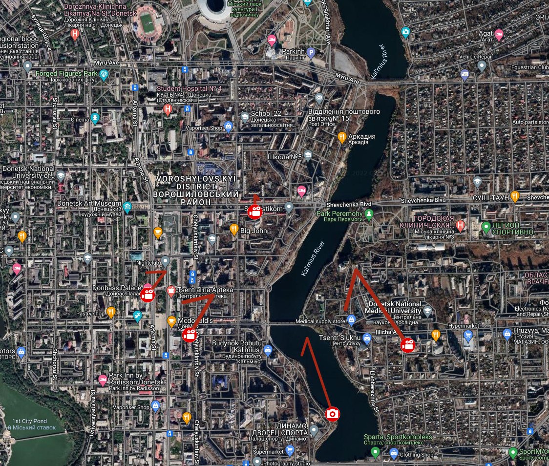
So these were 5 POV's we geolocated (we geolocated more, but for this thread we only use these 5.)
When placed on a map we get a clue of where the area of impact should be.
13/
When placed on a map we get a clue of where the area of impact should be.
13/
Based on the first video we can make an assessment about the number of impacts:
1,5km away from impact area.
Speed of sound 343 m/s so rougly 5 seconds delay. The movie starts immediately with the sound of impacts.
14/
https://twitter.com/leonidragozin/status/1533158430390861829
1,5km away from impact area.
Speed of sound 343 m/s so rougly 5 seconds delay. The movie starts immediately with the sound of impacts.
14/
When the last one occurred there is indeed a delay about 5 Seconds.
So how many impacts where there?
How much flashes do we see?
We see around 17+ flashes --> We can hear 5/6 before flashes reach the POV. So we have an estimation around 20-25 impacts.
15/
So how many impacts where there?
How much flashes do we see?
We see around 17+ flashes --> We can hear 5/6 before flashes reach the POV. So we have an estimation around 20-25 impacts.
15/
We have to take in account that it's at least around 25 impacts because the filming started when the shelling was already busy.
Timing of the shelling (video): 15 seconds.
(again we don't know how long it's been going on)
So this would mean 25/15= 0,6 sec for each impact.
16/
Timing of the shelling (video): 15 seconds.
(again we don't know how long it's been going on)
So this would mean 25/15= 0,6 sec for each impact.
16/
So now the "Impact" video's (with some analyses of those impact's).
We know there are at least 20 impacts, so footage should emerge. And it did.
In this thread we only analyse the impacts where we GeoConfirmed the location.
17/
We know there are at least 20 impacts, so footage should emerge. And it did.
In this thread we only analyse the impacts where we GeoConfirmed the location.
17/
Impact 01: "Massage & Spa"
GRID: 48.013194, 37.814042
GeoLocated by @Doppelot
Source: t.me/itsdonetsk/163…
18/
GRID: 48.013194, 37.814042
GeoLocated by @Doppelot
Source: t.me/itsdonetsk/163…
18/

GeoLocation Impact 01: "Massage & Spa"
19/
19/


Impact 02: "Residential Building"
GRID: 48.012574, 37.817595
GeoLocated by @doppelot
Source: t.me/itsdonetsk/163…
20/
GRID: 48.012574, 37.817595
GeoLocated by @doppelot
Source: t.me/itsdonetsk/163…
20/

GeoLocation Impact 02: "Residential Building"
21/
21/


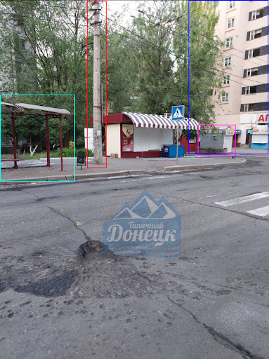
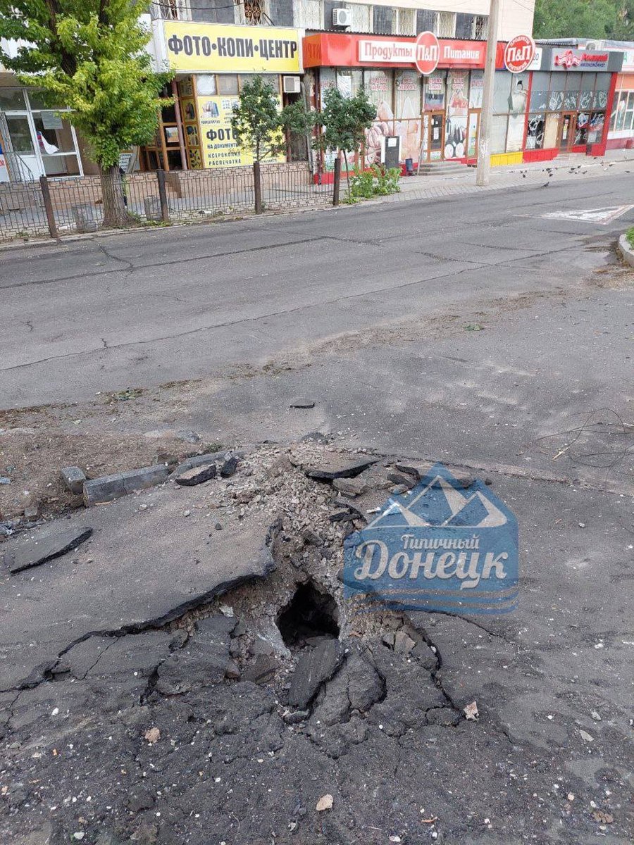
Impact 03: "Bus Stop"
GRID: 48.012905, 37.811800
GeoLocated by Doppelot
Source: t.me/itsdonetsk/163…
22/
GRID: 48.012905, 37.811800
GeoLocated by Doppelot
Source: t.me/itsdonetsk/163…
22/

GeoLocation Impact 03: "Bus Stop"
23/
23/

Impact 04: "Street Corner"
(2 pictures, same impact picture taken from opposite direction)
GRID: 48.012492, 37.811646
GeoLocated by @Doppelot and @rollowastaken
Source: t.me/itsdonetsk/163… and t.me/itsdonetsk/163…
24/
(2 pictures, same impact picture taken from opposite direction)
GRID: 48.012492, 37.811646
GeoLocated by @Doppelot and @rollowastaken
Source: t.me/itsdonetsk/163… and t.me/itsdonetsk/163…
24/


GeoLocation Impact 04: "Street Corner"
25/
25/


Impact 05: "Den"
GRID: 48.013260, 37.814655
GeoLocated by @kargolow
Source: t.me/itsdonetsk/162…
26/
GRID: 48.013260, 37.814655
GeoLocated by @kargolow
Source: t.me/itsdonetsk/162…
26/

GeoLocation Impact 05: "Den"
27/
27/

Impact 06: "White Van"
This was a complicated one, with more POV's. But there is a White Van near the impact so we use that as reference.
GRID: 48.01215, 37.81454
GeoLocated by @neonhandrail
VID 1:
28/
This was a complicated one, with more POV's. But there is a White Van near the impact so we use that as reference.
GRID: 48.01215, 37.81454
GeoLocated by @neonhandrail
VID 1:
https://twitter.com/TataTedoradze1/status/1533173764669771777
28/
GeoLocation Impact 06: "White Van" VID 1.
30/
30/

GeoLocation Impact 06: "White Van" VID 2.
31/
31/


3th video from Impact 06: "White Van"
32/
https://twitter.com/EnajenacionMund/status/1533182195761807361
32/
Impact 07: "Yellow Building"
GRID: 48.014761, 37.817705
GeoLocated by @kargolow
Source: t.me/itsdonetsk/162…
34/
GRID: 48.014761, 37.817705
GeoLocated by @kargolow
Source: t.me/itsdonetsk/162…
34/

GeoLocation Impact 07: "Yellow Building"
35/
35/

Impact 08: "Orange building"
GRID: 48.014047, 37.812647
GeoLocated by @doppelot and @neonhandrail
Source: t.me/itsdonetsk/162…
36/
GRID: 48.014047, 37.812647
GeoLocated by @doppelot and @neonhandrail
Source: t.me/itsdonetsk/162…
36/

GeoLocation Impact 08 "Orange building"
37/
37/

We found footage of other impacts also but we couldn't GeoConfirm those.
If we map those 8 impacts, this is what we get:
38/
If we map those 8 impacts, this is what we get:
38/

So we know WHAT happened = Donetsk is shelled with at least 8 GeoLocated impacts and at least 20 seen/heard impacts.
So WHEN? Around 2000 PM.
Every video we found was posted on 04 JUN in the evening and on 05 JUN.
39/
So WHEN? Around 2000 PM.
Every video we found was posted on 04 JUN in the evening and on 05 JUN.
39/
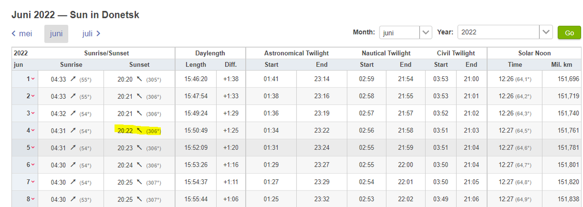

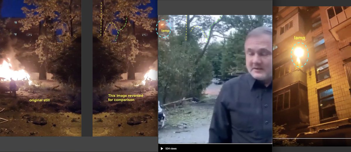
In different videos you can see a Sunset and the same cloud formations.
VID 1:
VID 2:
40/
VID 1:
https://twitter.com/leonidragozin/status/1533158430390861829
VID 2:
https://twitter.com/locumtenens_DPR/status/1533152239354888193
40/

We have the WHAT? and the WHEN? Now we go for the HOW: Which type of ammunition and/or launching platform is used?
What we already know is that the Target box is roughly 600x400m's. So whatever is used has a big impact spreading.
41/
What we already know is that the Target box is roughly 600x400m's. So whatever is used has a big impact spreading.
41/
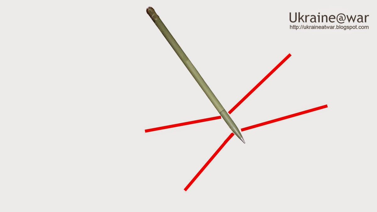
But we also found footage of ammunition remnants.
Impact 03: "Bus Stop"
42/
Impact 03: "Bus Stop"
42/

Impact 04: "Street Corner"
(No remnant, but the diameter of the hole is a sign)
43/
(No remnant, but the diameter of the hole is a sign)
43/
Impact 06: White Van
44/
44/


Based on the area of spreading and the ammunition remnants it is highly likely that a GRAD was used.
Source: aoav.org.uk/infographic/in…
45/
Source: aoav.org.uk/infographic/in…
45/


And the most common used launching platform is a BM-21 with a 9M22 rocket.
This combination has a range of 20km's.
With a Tornado-G the range can be extended to 40km's. But these are very rare.
46/
Source:
military-today.com/artillery/grad…
military-today.com/artillery/torn…
This combination has a range of 20km's.
With a Tornado-G the range can be extended to 40km's. But these are very rare.
46/
Source:
military-today.com/artillery/grad…
military-today.com/artillery/torn…

Some other interesting facts about a GRAD:
- 40 rockets
- a rocket is launched every 0.5 seconds
- maximum range of 20.4 km
- How further the range, how bigger the spreading of impacts.
47/
characterisationexplosiveweapons.org/studies/annex-…
- 40 rockets
- a rocket is launched every 0.5 seconds
- maximum range of 20.4 km
- How further the range, how bigger the spreading of impacts.
47/
characterisationexplosiveweapons.org/studies/annex-…
"At the moment of detonation, the basic warhead scatters a total of 3,922 fragments, killing and injuring anyone in its midst. The area affected by the blast and fragmentation of each high explosive warhead that strikes the ground is measured at 700m sq."
48/
48/
"This is an area roughly equivalent to a circle with a radius of 15m, although Grad rockets spit most of their fragmentation effects in an area forward of where the rockets land."
49/
49/
So based on the information of the impact area and the facts above, we can conclude it's highly likely that a Grad was used.
So we know the WHAT? WHEN? HOW? now we try to answer the FROM WHERE.
50/
So we know the WHAT? WHEN? HOW? now we try to answer the FROM WHERE.
50/
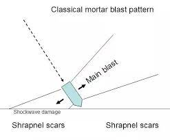
To asses the launch direction we based us on the known spreading pattern of a Grad Impact: This is a high angle type of ammunition. So the mortar perception of impacts is used.
Source: @bellingcat investigation
bellingcat.com/app/uploads/20…
51/
Source: @bellingcat investigation
bellingcat.com/app/uploads/20…
51/

So this graph we will project on the impacts to assess the direction from where it was launched.
More info: stopfake.org/en/analysis-of…
52/
More info: stopfake.org/en/analysis-of…
52/

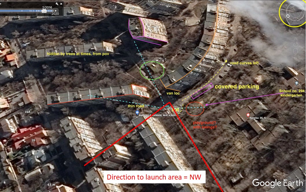
Impact 01: "Massage & Spa"
Direction to launch area = NW
53/
Direction to launch area = NW
53/

Impact 02: "Residential Building"
Direction to launch area = NW
54/
Direction to launch area = NW
54/

Impact 03: "Bus Stop"
Direction to launch area = NW
55/
Direction to launch area = NW
55/

Impact 04: "Street Corner"
Direction to launch area = NW
56/
Direction to launch area = NW
56/

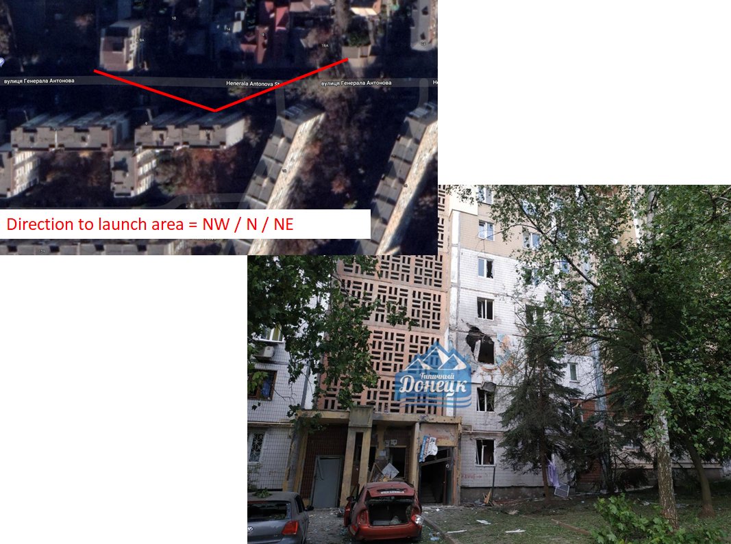
Impact 05 "Den"
Direction to launch area = NW / N / NE
57/
Direction to launch area = NW / N / NE
57/
Impact 06 "White Van"
Direction to launch area = NW
58/
Direction to launch area = NW
58/

On the last 2 impacts we can't make an assessment because they fell on a roof and we don't have a clear view on the impact.
Even with room for error, and based on the orientation of the buildings it's highly likely that the launch direction is to the NW of the impact area.
59/
Even with room for error, and based on the orientation of the buildings it's highly likely that the launch direction is to the NW of the impact area.
59/
If we put everything together (direction + BM-21 Grad) we can conclude that this should be the area from where the launch took place.
Black line = Frontline assessment of that day by @DavidBatashvili
60/
Black line = Frontline assessment of that day by @DavidBatashvili
60/


So what does this mean? The front line is approx 9 km's away from the impact zone.
The minimum range for the use of a GRAD is depending from which source is used between 3km and 5km (We don't take the Direct Fire method in account cause of the urban nature of impact area)
62/
The minimum range for the use of a GRAD is depending from which source is used between 3km and 5km (We don't take the Direct Fire method in account cause of the urban nature of impact area)
62/
Grad rockets have the same initial velocity so that means that their range is determent by the inclination.
Source: scielo.cl/img/revistas/j…
researchgate.net/publication/29…
63/
Source: scielo.cl/img/revistas/j…
researchgate.net/publication/29…
63/
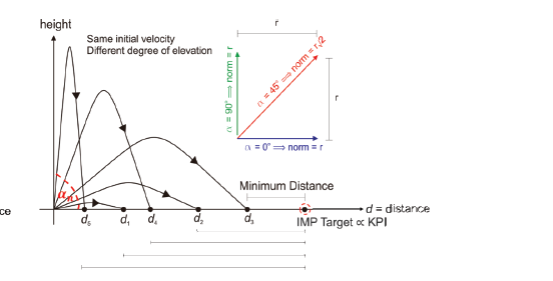
If we take a look at the impacts we see that the impacts have an angle between 30 and 45 degrees.
We also know that the impact zone is roughly 600m x 600m. How further you fire with a GRAD how bigger the spreading of impacts.
64/
We also know that the impact zone is roughly 600m x 600m. How further you fire with a GRAD how bigger the spreading of impacts.
64/


So who is responsible?
If this would be done by Russia that would mean they had to place their GRAD(s) on the active (!) frontline, which is unlikely.
65/
If this would be done by Russia that would mean they had to place their GRAD(s) on the active (!) frontline, which is unlikely.
65/
So based on all this information we can assume this was an Ukrainian attack with a GRAD BM-21 from the area West of Avdiivka. But can we find other information of this possibility?
66/
66/
On 31 MAY "The Sun" posted a video on YouTube titled "Ukrainian soldiers fire a flurry of rockets at Russian targets in Donetsk"
In this video you only see one BM-21 who fires a few rockets at targets in Donetsk.
So they were in the area.
/67
In this video you only see one BM-21 who fires a few rockets at targets in Donetsk.
So they were in the area.
/67
And then you also have the shelling history of Donetsk:
For Donetsk Ukraine has a history of using Unguided rockets.
hrw.org/news/2014/07/2…
68/
For Donetsk Ukraine has a history of using Unguided rockets.
hrw.org/news/2014/07/2…
68/
And in the recent weeks Ukraine shelled mostly military targets every day.
"17 1426 JUN - GEO - PIC - Military base in Kievsky District of Donetsk is hit"
69/
"17 1426 JUN - GEO - PIC - Military base in Kievsky District of Donetsk is hit"
https://twitter.com/GeoConfirmed/status/1537878301066137600
69/
And the Ukrainians are still close to Donetsk in the NW:
"17 1850 JUN - GEO - UAV - DNR artillery strikes on reported Ukrainian position"
70/
"17 1850 JUN - GEO - UAV - DNR artillery strikes on reported Ukrainian position"
https://twitter.com/GeoConfirmed/status/1537881162743308288
70/
Ukraine never officially denied that it wasn't them.
They are shelling military targets in Donetsk on a daily basis and if you use unguided rockets for it, it sometimes goes wrong.
The use of a GRAD against populated area's is by nature of the weapon system just wrong.
71/
They are shelling military targets in Donetsk on a daily basis and if you use unguided rockets for it, it sometimes goes wrong.
The use of a GRAD against populated area's is by nature of the weapon system just wrong.
71/
Russia is shelling dozens of cities with unguided rockets, they are committing a lot of war crimes and they violate the Convention of Geneva on a daily basis.
Conclusion:
In this case it is our assumption that this shelling was highly likely done by the Ukrainian military.
72/
Conclusion:
In this case it is our assumption that this shelling was highly likely done by the Ukrainian military.
72/
Something about the indiscriminate shelling of populated area's 👇
Protocol Additional to the Geneva Conventions of 12 August 1949, and relating to the Protection of Victims of International Armed Conflicts (Protocol I), 8 June 1977.
👇
73/
Protocol Additional to the Geneva Conventions of 12 August 1949, and relating to the Protection of Victims of International Armed Conflicts (Protocol I), 8 June 1977.
👇
73/

For this thread I want to thank all the @GeoConfirmed volunteers. You can follow them by following the members of this list: twitter.com/i/lists/153567…
I want to thank some members of the @bellingcat discord, who participated in the search for the truth.
74/
I want to thank some members of the @bellingcat discord, who participated in the search for the truth.
74/
I want to thank @DefMon3, @Nrg8000 and some members of @bellingcat and @Cen4infoRes for the advice.
We still have some other investigations going on.
We especially investigate doubtful events.
But after all there is no doubt that Russia is the lying aggressor in this war.
75/
We still have some other investigations going on.
We especially investigate doubtful events.
But after all there is no doubt that Russia is the lying aggressor in this war.
75/
Other threads from GeoConfirmed (And members).
"01 APR 2022: The Ukrainian Ambush near #Dmytrivka (+ killing of POW’s)"
76/
"01 APR 2022: The Ukrainian Ambush near #Dmytrivka (+ killing of POW’s)"
https://twitter.com/GeoConfirmed/status/1509936781415919621
76/
"11 APR 2022: The Kramatorsk strike:
78/
https://twitter.com/GeoConfirmed/status/1513316193536458757"
78/
"12 MAY 2022: Ukrainian forces in Mariupol come under attack, one soldier was hit by gunfire. Grenade lobbed back at Russian forces."
79/
https://twitter.com/GeoConfirmed/status/1524695647340929026
79/
From volunteers:
23 APR 2022, by @brechtcastel
"Ukrainian soldier: "We had orders to shoot to kill at any moving person, whether it was peaceful or not."
81/
23 APR 2022, by @brechtcastel
"Ukrainian soldier: "We had orders to shoot to kill at any moving person, whether it was peaceful or not."
https://twitter.com/brechtcastel/status/1517780064209088512
81/
26 APR 2022, by @kargolow
"the video of Ukrainian prisoners of war appeared on social media (see first screenshot)."
82/
"the video of Ukrainian prisoners of war appeared on social media (see first screenshot)."
https://twitter.com/kargolow/status/1518920554883035140
82/
04 MAY 2022, by @brechtcastel
"2M people have seen this picture on #Telegram (without blur): "🇷🇺 Russian soldier was chained [...] tortured and [...] set on fire while still alive."
83/
"2M people have seen this picture on #Telegram (without blur): "🇷🇺 Russian soldier was chained [...] tortured and [...] set on fire while still alive."
https://twitter.com/brechtcastel/status/1521860946419154944
83/
07 JUN 2022, by @kargolow
"Footage showing railway transport of military equipment somewhere in Irkutsk oblast appeared today"
84/
"Footage showing railway transport of military equipment somewhere in Irkutsk oblast appeared today"
https://twitter.com/kargolow/status/1534285505688485890
84/
15 JUN 2022, by @brechtcastel
"A Russian missile 🇷🇺 killed at least three Ukrainian citizens 🇺🇦 on April 16 in Kyiv."
85/
"A Russian missile 🇷🇺 killed at least three Ukrainian citizens 🇺🇦 on April 16 in Kyiv."
https://twitter.com/brechtcastel/status/1537046371907342338
85/
• • •
Missing some Tweet in this thread? You can try to
force a refresh


