#ClimateChangeMusings Thread
It is said that "history does not repeat" but that rather "it rhymes". And this is a #RhymingWeather reflection. Last night a massive, storm which had not been forecasted took place over Germany at night. Here is a 24 hour animation of the event.
It is said that "history does not repeat" but that rather "it rhymes". And this is a #RhymingWeather reflection. Last night a massive, storm which had not been forecasted took place over Germany at night. Here is a 24 hour animation of the event.
https://twitter.com/althecat/status/1550136557226655745
A year and a week ago today the weather system that dumped torrential rain for 48 hours over Western Germany, and took 154 souls started.
It was this storm more than anything which woke up the Western World to the consequences of #ExtrremeWeather.
theguardian.com/world/2022/jul…
It was this storm more than anything which woke up the Western World to the consequences of #ExtrremeWeather.
theguardian.com/world/2022/jul…
On the same day 14/July/21 the @EU_Commission issued a press release announcing the Green New Deal. And as rain was falling nearby they held a press confernce on July 15th to answer questions about the "Fit for 2055" plan which is set to transform Europe. ec.europa.eu/commission/pre…
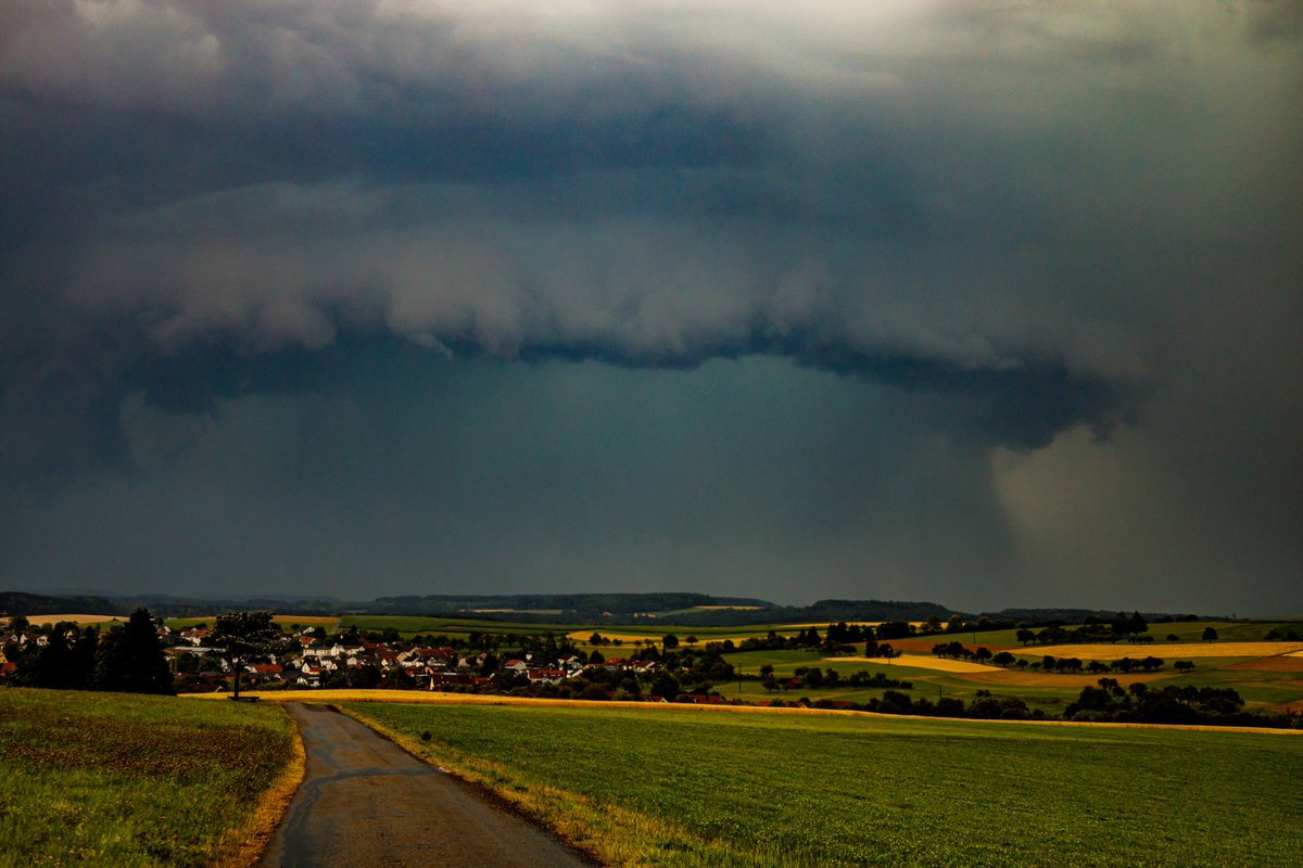
This is the storm last night in closeup. Remarkably the size and intensity of the storm was not forecast. No weather warnings were issued. Focus was on anticipated record setting heat instead.
The storm is still in place now is 811kms and covers all of Germany.
The storm is still in place now is 811kms and covers all of Germany.
A smaller storm had been predicted, smaller with only around 40-50mm of rain, one model said 75mm.
Looking afterwards at the forecaset morels I discovered none of the high tech computer models for weather - global and European - had provided warning.
Looking afterwards at the forecaset morels I discovered none of the high tech computer models for weather - global and European - had provided warning.
https://twitter.com/althecat/status/1549846555607416836?s=20&t=7WIvy3QeaS6kis_M0H9ewA
I spotted the storm at 9pm CEST on @zoom_earth and immediately went to look for news reports. A storm of this magnitude is a significant news event usually. I found nothing. I then looked at the forecasts and added them to my thread.
https://twitter.com/althecat/status/1549849380861218819?s=20&t=7WIvy3QeaS6kis_M0H9ewA
@zoom_earth It was clear that something was wrong.
I checked again to be sure - comparing the forecast extent of the storm and satellite imagery - which showed by then an area of around 40,000 km2 experiencing heavy rain - i.e. rain of up to 40L per M2 per hour.
I checked again to be sure - comparing the forecast extent of the storm and satellite imagery - which showed by then an area of around 40,000 km2 experiencing heavy rain - i.e. rain of up to 40L per M2 per hour.
Around 9.30pm I looked for weather warnings and initially found only heat warnings. By this stage the storm was huge. The leading storm front was roughly the size of Belgium
https://twitter.com/althecat/status/1549860744388296705?s=20&t=7WIvy3QeaS6kis_M0H9ewA

The tweet quoted above was posted at close to 11pm and the warning page I realise belonged to a news service. By then warnings had been issued on @Meteoalarm - though not till 10:40pm German time. The storm began at 6pm & crossed into Germany at 7pm.
https://twitter.com/althecat/status/1549876491999223809?s=20&t=7WIvy3QeaS6kis_M0H9ewA
@meteoalarm I figured out where the Ahr valley was and was pleased to discover the main rain bands had not passed over it - which must have been a massive relief to those living there. There was still no news on any websites. By now it was midnight for me, 1 am in Germany.
This video was posted this morning with footage from the storm - not sure where the first footage is perhaps in Lake Constance - Switzerland also experienced a smal taste of the storm early evening.
I wanted to capture evidence of the warning system not working and looked for another good example - this was provided by Nuremberg. Which like all of Germany early in the evening had only been issued with a wind warning.
https://twitter.com/althecat/status/1549888562442682369?s=20&t=7WIvy3QeaS6kis_M0H9ewA
Here you see contemporaneous satellite imagery showing the storm coming very close to the city - it later crossed over.
https://twitter.com/althecat/status/1549889126920589316?s=20&t=7WIvy3QeaS6kis_M0H9ewA
All of which is a long way of saying that if we fail to learn from our mistakes we are condemned to repeat them.
1. This storm is a reminder of the need for Europe to harden its #extrermeweather warning systems.
1. This storm is a reminder of the need for Europe to harden its #extrermeweather warning systems.
2. And these warning systems clearly ought not to rely entirely on what are usually superbly reliable computerised forecasting systems.
This incident is proof that these systems can miss a major weather event in Europe, literally as it is beginning.
This incident is proof that these systems can miss a major weather event in Europe, literally as it is beginning.
Many of the forecasts for the evening had output runs at 6pm - which is the time that the storm began. Ordinarily these systems provide five and often up to 10 days warnings of dangerous weather.
For thosew who are interested this thread continues the story of the night starting a 1.20pm. And includes a small search to try to figure out why the weather models missed this event.
https://twitter.com/althecat/status/1549896760226709510?s=20&t=7WIvy3QeaS6kis_M0H9ewA
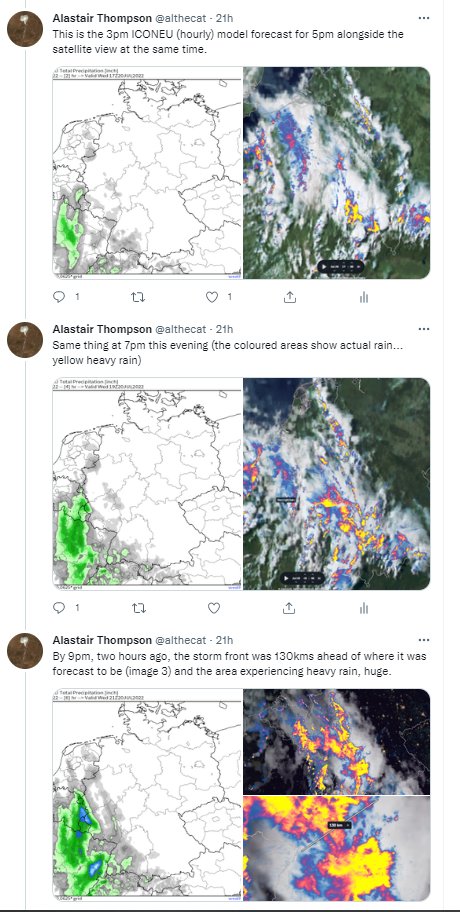
This section of the thread looks again at the global/europe weather model forecasts.
https://twitter.com/althecat/status/1549908933799723010?s=20&t=7WIvy3QeaS6kis_M0H9ewA
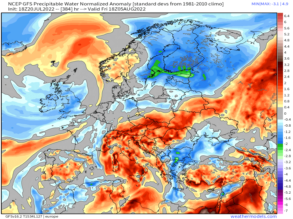
And here I get into a discussion about why the models got the forecast wrong. Simple answer is that it was a very complex set up - water coming from all directions - and I think the intensity of a water source coming from the south was a common error.
https://twitter.com/althecat/status/1549920853479006209?s=20&t=7WIvy3QeaS6kis_M0H9ewA
Wehn it comes to the complexity of the set up this animation shows the 24 hours leading up to the storm. It appears to show water coming south over Ireland - turning france 360 degrees over France and heading back north east into Germany.
https://twitter.com/althecat/status/1549943039786946565?s=20&t=7WIvy3QeaS6kis_M0H9ewA
And this is where I think the models went wrong. They identified this source of water as important ( it is an atmospheric river coming up the Moroccan Coast) - but it's intensity was wildly underestimated

IMO, I will leave that to the experts to decide. This animation shows the magnitude of the atmospheric water column - i.e. water in the sky. But as you saw in the image earlier - water can go every which way inside the column which is around 8-10kms high.
https://twitter.com/althecat/status/1549924103213252609?s=20&t=7WIvy3QeaS6kis_M0H9ewA
• • •
Missing some Tweet in this thread? You can try to
force a refresh