91L is up to an 80 percent chance of developing this week, per the NHC. Once it does, it will be named Danielle -- and we'll have a better idea who the storm would eventually threaten -- if anyone. 1/x
This morning, modeling seems to indicate a slw strengthening, then a recurve somewhere north of the Bahamas. Obviously that's good news for the Carolinas -- especially after last night's GFS run. 2/x
That said, there are 3 things that need to happen before we can put confidence in not having Danielle threaten. 1. Consolidation 2. Strength 3. Synoptics
Let's take each in order: 4/x
1. Consolidation: This morning #91L is a stretched-out wave running SW to NE from 12N to 17N and 53W to 43W. That's a large area for modeling to try to decide where the system will go. Consolidation further north increases the odds that 91L will eventually slide northeast. 5/x
BTW, in that WV graphic, you can also see the effect of an upper-level low in the top left corner. It's shearing the top part of 91L, which could hamper development. That's why the NHC has been upping the 5-day odds, after 91L has slipped past the ULL. 6/x
2. Strength: As any seasoned #Weatherhounds know, the stronger a system gets, the more it wants to pull to the north and east. Weaker storms tend to get steered by lower-level winds, which are pushing west and WNW this time of year in the Atlantic. 91L is in their grip now. 7/x
That ULL and generally dry conditions will do a number of 91L for a few more days before relenting. When that happens, look for then-Danielle to intensify and start looking for a way north. Every additional 12 hours that takes means the system gets about 150 miles closer. 8/x
Take a quick look at this morning's GFS spaghetti chart. The overall tendency is to slide Danielle NW (eventually into a recurve). But within that overall pattern you can see the subtle differences in speed and strength, and the effects those have downstream. 9/x
That brings us to 3. Synoptics: What's going on downstream? Why did most modeling show a sudden sweep off the Southeast coast? In a word: troughing. Look at the difference between last night's GFS (the Carolina landfall) and today's out-to-sea solution. 10/x
There are a lot of reasons for this chance, and as we get closer, we can discuss what's happening. For now, just know that (a) if Danielle forms along the timeline and location projected and (2) that sort of troughing occurs, then out-to-sea is the likely outcome.
• • •
Missing some Tweet in this thread? You can try to
force a refresh
All eyes (well, except for those following the GFS phantom doomsday storm in the Gulf) are on #91L this weekend. But down the road, that little yellow dot to its north may have a lot to say about things. Why? 1/x
The little dot (let's call it a lemon) will never be a threat, and likely won't even make tropical depression status. It's trying to develop in a region of dry air and shear -- sort of like FAMU vs. UNC or Duquesne vs. FSU last night, the odds are stacked against it. 2/x
Current moisture levels in that area are similar to what we see in October: PWATs below 1.25 inches and humidity that would feel refreshing to us -- but not to a system trying to develop. 3/x
Treyce with an interesting observation on the 12Z Euro. Timing is essential when these systems are trying to make it across the Atlantic. Often gaps between highs open, allowing the storm to sniff a path to the north. 1/x
As the Euro runs unfold, note the increased forward speed and the latitude in each run in relation to the high pressure influencing its track. As Euro shift the high from the Carolinas to New York, it allows the storm to slide north of Hispaniola. 2/x
Placement of the high is as important as strength. In the 0Z run, the high is weaker, but sitting over the southern Apps, and the storm steers to the west (left). 12Z run has a stronger high 1029 vs. 1023, but well to the north. Less resistance for the storm as it moves north.
A few tidbits as you wait for the coffee to cook:
Isaias is still a stopical storm, but THIS CLOSE to being a Cat 1 hurricane. In fact, it's a foregone conclusion that it will be Hurricane #Isaias by landfall in the Carolinas. 1/x
Barring something totally off the wall, that landfall will take place late tonight or very early Tuesday. Location has narrowed to the upper Grand Strand or SENC south-facing beaches as the most likely target, but that's less certain. 2/x
The Central and southern Sandhills, including FAY and Fort Bragg, remain under a Tropical Storm Warning with winds above 40 mph expected and gusts possibly up to 60 mph. Pockets of torrential rain are likely after sunset. 3/x
OK, here's the view for the Sandhills and points east. There are two caveats before we start micro-managing, however: The strength of #Isaias at landfall and where exactly the landfall takes place. With a storm this small, both are subject to change in the next 36 hours. 1/x
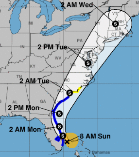
First the official word from the NHC: They anticipate #Isaias to remain below hurricane strength as it turns and races up the East coast beginning tomorrow. Included in that track is a run through the southern Sandhills Tuesday morning. 2/x
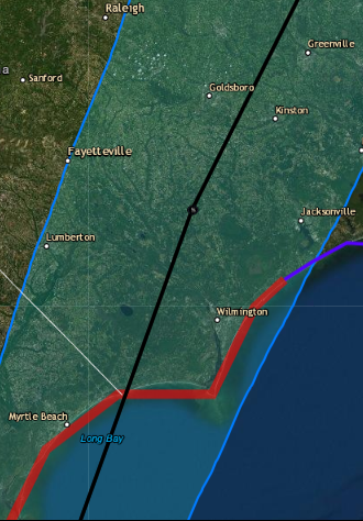
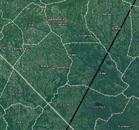
A closer look at the current NHC track shows a coninuted westward crawl. Yesterday morning the cone center came ashore near Wilmington. Today, it's more like Georgetown, SC, running inland near Whiteville, E'town and Clinton. That's abt. 30 miles SE of FAY. 3/x