Chick Jacobs Profile picture
The weather source in the N.C. Sandhills for #Weatherhounds everywhere. If cancer's gonna kill me, it'll have to try harder #FightLikeHell True son of Clemson.
Sep 28, 2022 10 tweets 4 min read
Once again, there are several quality folks who are rightly focusing on #Ian's impending devastation in Florida. At this point it's about impossible to over-hype the potential for damage. So, let's take a look at second - yes, second - landfall potential further north. 1/x🧵 Overnight modeling has all but conceded that #Ian is going to at least get its toes in the Atlantic. It won't recover the destructive power found in the Gulf, but a second landfall in Georgia or SC appears likely. 2/x
Sep 27, 2022 7 tweets 3 min read
A couple of notes from the NHC's 11 a.m. update:
1. The track, as expected, has shifted slightly to the east. Much of the Big Bend area, which was Ground Zero 2 days ago, are entirely out of the cone now. Relief for the folks hammered by Michael. Image 
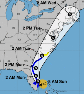
Also the center of the NHC cone is just south of Tampa Bay. That would be huge for the metro area. If the bay can stay to the north of Ian's center of circulation, water will be pushed out, rather than into, the bay. Image
Sep 27, 2022 8 tweets 3 min read
There's a quite a bit to unpack with #Ian this morning, and a lot of solid folks are dealing with its approach to FLA. As you know, my focus is on the Carolinas, so let's start there. 1/x If you think the official NHC map looks a little different this morning, you're correct. Overnight, the NHC tweaked it a bit to the south and east, which puts the Sandhills more squarely in the 5-day Cone of Uncertainty. 2/x
Sep 26, 2022 8 tweets 4 min read
#Ian made the jump to hurricane overnight ... looks pretty healthy this morning, too. Modeling is locking in on landfall north of Tampa into the Big Bend area. There are a couple of interesting outliers, however. The most intriguing outlier, as far as interests in the Carolinas go, is the ICON. It still develops Ian into a near Cat 4 storm just before landing south of Tampa. Rather than sliding north That's 36 hours over FLA. 1/x
Sep 25, 2022 10 tweets 4 min read
As of Sunday evening, it's looking more likely that the Carolinas won't have to worry about #Ian slipping back into the Atlantic for more East Coast mischief.
That doesn't mean portions of the Carolinas will escape unscathed, however. Why? Let's take a look ... 🧵1/x This evening, the models are still uncertain about just where in Florida or just when #Ian will land. The further up the west coast it goes, the later the arrival. But once there, it looks like the storm will remain inland. 2/x
Aug 29, 2022 10 tweets 3 min read
91L is up to an 80 percent chance of developing this week, per the NHC. Once it does, it will be named Danielle -- and we'll have a better idea who the storm would eventually threaten -- if anyone. 1/x 
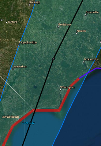
This morning, modeling seems to indicate a slw strengthening, then a recurve somewhere north of the Bahamas. Obviously that's good news for the Carolinas -- especially after last night's GFS run. 2/x
Aug 28, 2022 7 tweets 2 min read
All eyes (well, except for those following the GFS phantom doomsday storm in the Gulf) are on #91L this weekend. But down the road, that little yellow dot to its north may have a lot to say about things. Why? 1/x The little dot (let's call it a lemon) will never be a threat, and likely won't even make tropical depression status. It's trying to develop in a region of dry air and shear -- sort of like FAMU vs. UNC or Duquesne vs. FSU last night, the odds are stacked against it. 2/x
Aug 26, 2022 4 tweets 2 min read
Treyce with an interesting observation on the 12Z Euro. Timing is essential when these systems are trying to make it across the Atlantic. Often gaps between highs open, allowing the storm to sniff a path to the north. 1/x As the Euro runs unfold, note the increased forward speed and the latitude in each run in relation to the high pressure influencing its track. As Euro shift the high from the Carolinas to New York, it allows the storm to slide north of Hispaniola. 2/x
Aug 3, 2020 8 tweets 3 min read
A few tidbits as you wait for the coffee to cook:
Isaias is still a stopical storm, but THIS CLOSE to being a Cat 1 hurricane. In fact, it's a foregone conclusion that it will be Hurricane #Isaias by landfall in the Carolinas. 1/x Barring something totally off the wall, that landfall will take place late tonight or very early Tuesday. Location has narrowed to the upper Grand Strand or SENC south-facing beaches as the most likely target, but that's less certain. 2/x
Aug 2, 2020 12 tweets 6 min read
OK, here's the view for the Sandhills and points east. There are two caveats before we start micro-managing, however: The strength of #Isaias at landfall and where exactly the landfall takes place. With a storm this small, both are subject to change in the next 36 hours. 1/x First the official word from the NHC: They anticipate #Isaias to remain below hurricane strength as it turns and races up the East coast beginning tomorrow. Included in that track is a run through the southern Sandhills Tuesday morning. 2/x