
For the first time since 1941, the Atlantic has had no named storm (e.g., tropical storm or #hurricane) activity from July 3rd-August 30th.
Since 1950, two Augusts have had no Atlantic named storm formations: 1961 and 1997. It remains to be seen if 2022 will join this list. 1961 ended up a hyperactive #hurricane season with an extremely busy September-November, while 1997 was a below-average season.
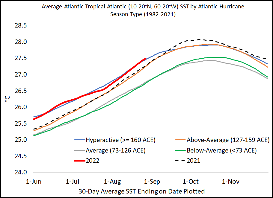
This remarkable quiet period is even more impressive given we have a robust #LaNina in the tropical Pacific and anomalously warm tropical Atlantic. Current 30-day-averaged tropical Atlantic sea surface temperatures are 6th warmest since 1982 and typical of a hyperactive season. 

1941 was a good year for Ted Williams, the Splendid Splinter. The last Major League Baseball player to hit over .400 in a single season. He hit a whopping .406 that year.
A great real-time seasonal Accumulated Cyclone Energy forecast from @wx_tiger shows how quickly expectations for the 2022 Atlantic #hurricane season have changed.

Colorado State University's final seasonal #hurricane forecast was issued in early August, but the odds of these forecasts verifying correctly are going down by the day. However, #LaNina seasons often have very busy ends, so it's too early to write the season off yet.
Why has it been so quiet the past few weeks? One reason has been a robust tropical upper-tropospheric trough and associated increases in vertical wind shear in the Caribbean/central tropical Atlantic.
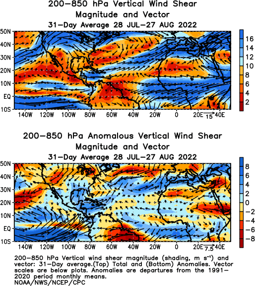
While shear has been stronger than anticipated, it's still not that high. 30-day-averaged shear across the Caribbean and tropical Atlantic is tracking between an average and above-average #hurricane season. Shear is stronger than typical #LaNina year, however.


Generally vertical motion over the past two weeks would favor Atlantic #hurricane activity, with rising motion over Africa/Indian Ocean and sinking motion over the tropical Pacific. This typically leads to more vigorous African easterly wave disturbances and lower Atlantic shear.

Even perfect knowledge of sea surface temperatures and wind shear during peak Atlantic #hurricane season only explains ~50-60% of the variance in Atlantic activity:
agupubs.onlinelibrary.wiley.com/doi/full/10.10…
That's the challenge of forecasting weather events on climate timescales.
agupubs.onlinelibrary.wiley.com/doi/full/10.10…
That's the challenge of forecasting weather events on climate timescales.
With that being said, overall vertical motion looks broadly favorable for Atlantic #hurricane activity, following a convectively-suppressed Kelvin wave in the short term. @MJVentrice


As I've said before, forecasting the weather and climate keeps you humble! The anemic Atlantic #hurricane response may also be due to 3rd year La Nina. Very small sample size to do much with this, but dynamical models didn't see this as an issue, as they forecast a busy season.
One of the odder seasons in recent history is 2001. No Atlantic #hurricanes through September 8th, but ended up with 9 hurricanes overall.

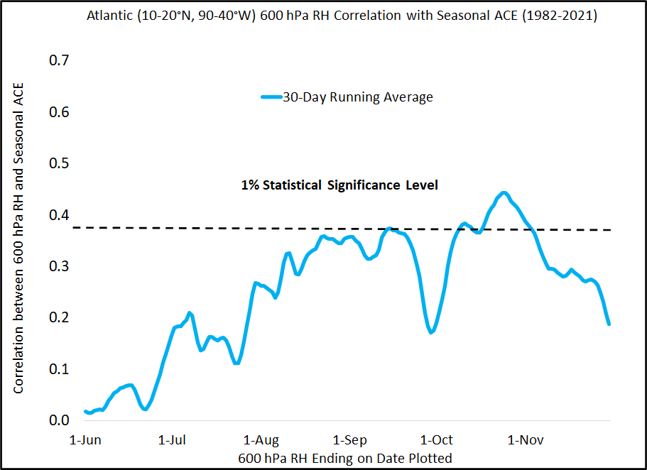
While the central tropical Atlantic/Caribbean has generally been dry, it's not hugely anomalous. Moisture also has lower correlations with seasonal Atlantic #hurricane activity than sea surface temperatures or vertical wind shear.

• • •
Missing some Tweet in this thread? You can try to
force a refresh


